

Spanks45
-
Posts
4,368 -
Joined
-
Last visited
Content Type
Profiles
Blogs
Forums
American Weather
Media Demo
Store
Gallery
Everything posted by Spanks45
-
I moved to CT in December of 2014, my previous "record" year was 72" during the 95/96 season living in Millersville, PA.
-
Best snowfall season I have ever experienced in my lifetime of 37 years(I measured 73 inches where I lived in Newtown)...hoping to someday top that year without having to move north.... Any ideas on the record snowfall for a season is for the Southbury/Newtown region is?
-
No kidding, in December on top of it....yet a polar bear belches and it snows to the coast, in October...
-
Its a great grill...I had the previous model for 11 years, 6 of those were spent in the salty air of Delaware which led to premature rusting.
-
Up to 62⁰, now the sun is out...feels great! Turkey is grilling away.
-
The ridge is well north of Alaska past 14 days...that should deliver some arctic air and shut off the Pac for a while
-
60⁰ with no rain here....Happy Thanksgiving! Grilling the turkey later, so this weather will be perfect if it continues...
-
Looking forward to having something to track, hopefully once we get past 12/5. I remember in the early part of the decade how that date always seemed to bring some sort of snow to the Mid Atlantic region.
-
That almost looks like a +PNA, -AO, -NAO situation there.....
-
This winter is definitely going to be a year for little to no snow retention for SNE. Probably go from snow and 15 degrees to 50 and rain 2 days later...
-
Keep pumping that PNA ridge and I will feel a bit better....Alaska needed some cold and snow to start so our air once the ridge builds would be colder. Can't cook that region early on or we won't have any cold air to work with later into winter right? Mid December to February 1st winter is fine with me....
-
18z GEFS looked pretty good at the end of the run...
-
Good point, definitely a different look from last year though. I seem to remember the -PNA with a huge trough sitting well into So Cal....
-
That weekend starts to show the PNA ridge building into the beginning of December, might be the "thread the needle" period for the region...IF of course the PNA is for real. There also seems to be alot of systems slamming into the west coast. What is this El Nino? odd.....
-
We have 1 thing going in the right direction it seems... PNA is rising as we head into December, maybe that will build into a -EPO as we go deeper into the month.
-
Looks like 16.2⁰ was the low....a solid 1.5 days of winter, back to fall for the foreseeable future
-
I know...all in jest, it can't get worse than last year, right? I will enjoy any snow we get, especially after the past 8 months. Already down to 22.3⁰ here in death valley after a high of 33. Saw a few flakes here this morning, even saw a nice coating in Newtown while was there. Nice to see at least....
-
Coldest night for the rest of the year incoming?...maybe coldest night of the winter season? Already 25.2⁰ here.....
-
I hope not...just a few mangled flakes here. Sure does feel like winter now, at least for the next day and a half.
-
I know, hopefully we get a reverse of last year. Long range looked great, but we never got it...but we are asking 2020 to actually be positive, so who knows. We can all put this aside when we are enjoying our first winter storm warning of the season.
-
All that blocking (it is on the ensembles as well). Unfortunately there is no cold air anywhere nearby. So we end up with weather similar to May instead of late November
-
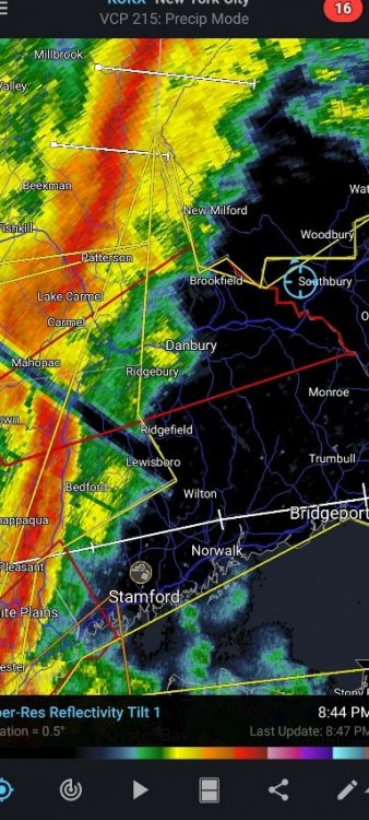
Why not...tornado warning headed right in this direction, 2020?
-
Power flickering here already...impressive windswept rains so far...I am sure the squall line will under perform
-
greatest decision my family made! We have actually been homeschooling for 3 years now and haven't missed a beat...We have missed the lack of sports though. Thankfully we moved back in August and our cul-de-sac has multiple families with kids almost all the same age and they are getting together to play almost everyday, social distancing of course. I can;t even imagine what it would be like if both of us worked and had to deal with the on and off remote schooling, just a nightmare.
-
GFS from Day 5 through the end of the run looks quite blocky in the NAO region....would be nice and hopefully we can score something region wide before it breaks down. GFS shows something right before Turkey Day. If the blocking even develops to begin with....


