StormfanaticInd
-
Posts
2,065 -
Joined
-
Last visited
Content Type
Profiles
Blogs
Forums
American Weather
Media Demo
Store
Gallery
Everything posted by StormfanaticInd
-
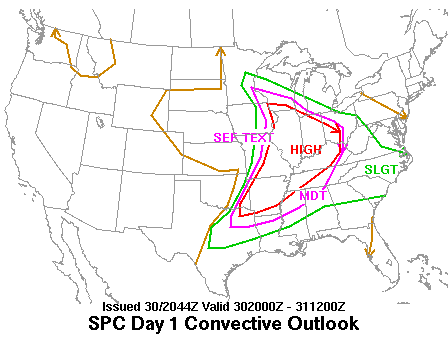
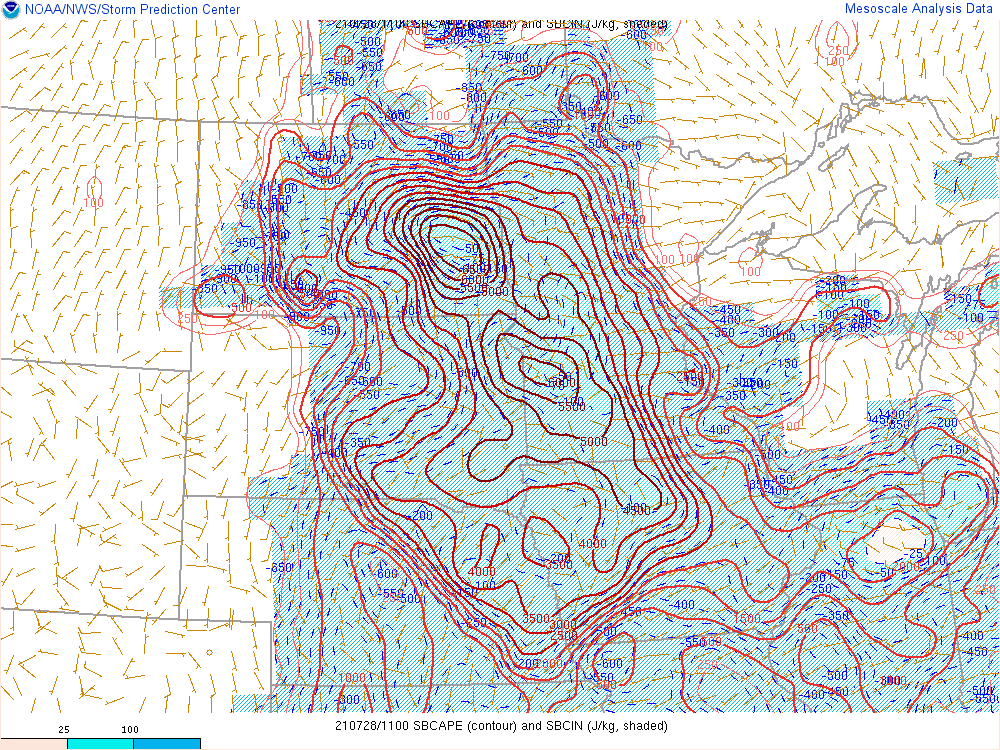
Today has explosive potential
-
WOW!!! You don't see this too often. 6500 cape already!!!
-
Everything is in place for a derecho to happen. Just a question of where?
-
2021 Short/Medium Range Severe Thread
StormfanaticInd replied to Hoosier's topic in Lakes/Ohio Valley
KIND The final issue for the short term and the one that is likely to have the greatest impact on just exactly how Thursday plays out focuses on the expectation of a mesoscale convective complex to organize across the upper Midwest Wednesday evening in tandem with a strong upper level wave. Trajectories support a southeast moving cluster that will likely produce severe weather Wednesday night aided by an impressive near 50kt 850mb jet. The general movement on the system would bring it into N/NE Indiana during the predawn hours Thursday with at least some potential that the tail end of the cluster works south into part of the northern forecast area. Considering the possibility that this system will mature enough to develop a cold pool...am almost anticipating that the convection will develop further back on its southwest flank into parts of central Indiana near daybreak Thursday. The questions that remain are...how far S/SW into the forecast area the storms can make it Thursday morning and what intensity will they have when they arrive? The nocturnal jet will weaken by 12Z Thursday and largely remain to the north of central Indiana. That would suggest that if the convective complex becomes cold pool dominant...at some point the storms will outrun their low level fuel source...weaken and eventually diminish. At this point...that will likely take place somewhere across the northern half of the forecast area Thursday morning. Still a lot of details to work out...but there is some merit that this could serve as the initial salvo in a 1-2 convective punch for the region by leaving a leftover boundary for new storms to fire on later on Thursday. It also presents some uncertainty with how much convective cloud debris departs Thursday morning and how that might impact available instability for new storms later in the day. -
Spring/Summer 2021 Banter/Complaint Thread
StormfanaticInd replied to madwx's topic in Lakes/Ohio Valley
More smoke Another toasty afternoon for the region with a noticeable increase in the haze over Monday as more smoke aloft has drifted into the region. The HRRR vertically integrated smoke parameters look to increase again on Wednesday as another surge of greater concentrated smoke extends into the region...although the highest levels of smoke should largely remain to the northwest -
2021 Short/Medium Range Severe Thread
StormfanaticInd replied to Hoosier's topic in Lakes/Ohio Valley
Mcs Wednesday night could squash the severe threat Thursday -
Spring/Summer 2021 Banter/Complaint Thread
StormfanaticInd replied to madwx's topic in Lakes/Ohio Valley
Covid is not like "every other" infection. That should be more than obvious by now. -
2021 Short/Medium Range Severe Thread
StormfanaticInd replied to Hoosier's topic in Lakes/Ohio Valley
-
2021 Short/Medium Range Severe Thread
StormfanaticInd replied to Hoosier's topic in Lakes/Ohio Valley
I was just about to post about that. Insane parameters and if verifies could get very interesting -
60 percent chance of a watch for the Chicago area
-
Cumulus clouds building overhead. Wonder if I will hear thunder today
-
Spring/Summer 2021 Banter/Complaint Thread
StormfanaticInd replied to madwx's topic in Lakes/Ohio Valley
Going to be close. Lol -
Spring/Summer 2021 Banter/Complaint Thread
StormfanaticInd replied to madwx's topic in Lakes/Ohio Valley
-
Spring/Summer 2021 Banter/Complaint Thread
StormfanaticInd replied to madwx's topic in Lakes/Ohio Valley
Only good thing about the smoke is that it's keeping temperatures in check. Also may be contributing to lower instability -
Spring/Summer 2021 Banter/Complaint Thread
StormfanaticInd replied to madwx's topic in Lakes/Ohio Valley
Another smokey day -
Summer/Fall 2021 Medium/Long Range Discussion
StormfanaticInd replied to MazooWeather's topic in Lakes/Ohio Valley
-
Summer/Fall 2021 Medium/Long Range Discussion
StormfanaticInd replied to MazooWeather's topic in Lakes/Ohio Valley
Severe weather looks very possible next week with storm clusters -
Spring/Summer 2021 Banter/Complaint Thread
StormfanaticInd replied to madwx's topic in Lakes/Ohio Valley
The delta variant seems to be stronger and affects young people more easily. As far as the fall and winter there are many variables at play. Pretty much flying somewhat blind. Hopefully it doesn't get too out of control *Edit Yikes Florida had over 12k cases today -
Spring/Summer 2021 Banter/Complaint Thread
StormfanaticInd replied to madwx's topic in Lakes/Ohio Valley
I only bring it up because we are indeed in a fourth wave which sucks -
Seems like a good mcs/mcc pattern next week
-
Spring/Summer 2021 Banter/Complaint Thread
StormfanaticInd replied to madwx's topic in Lakes/Ohio Valley
We are indeed in a fourth wave folks. Even I didn't think this would happen again. Yikes -
Summer/Fall 2021 Medium/Long Range Discussion
StormfanaticInd replied to MazooWeather's topic in Lakes/Ohio Valley
If this pattern keeps up it will once again mean early season cold for the fall -
"Widespread haze. Partly cloudy, with a low around 64. North wind 5 to 7 mph becoming light and variable after midnight."
-
I've never seen so much haze/smoke. I think it actually held the temperature down
-
Spring 2021 Medium/Long Range Discussion
StormfanaticInd replied to madwx's topic in Lakes/Ohio Valley
This pattern could have implications down the road later in the year if it sticks around

