StormfanaticInd
-
Posts
2,065 -
Joined
-
Last visited
Content Type
Profiles
Blogs
Forums
American Weather
Media Demo
Store
Gallery
Everything posted by StormfanaticInd
-
2021 Short/Medium Range Severe Thread
StormfanaticInd replied to Hoosier's topic in Lakes/Ohio Valley
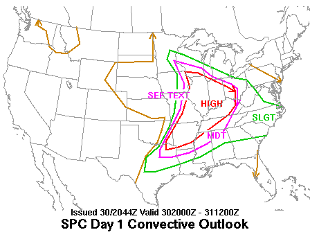
KIND. Focus will then shift to a surface wave kicking out across the Central Plains along the boundary. This will pull the boundary back north into the forecast area Thursday night with what is likely to be the most organized threat for convection as the surface wave tracks through the forecast area Friday morning. Expect widespread showers and storms with the low pressure passing through the region late Thursday night into Friday and riding along the instability gradient which at this point which is likely to setup over the forecast area in the vicinity of the front. With the presence of a stronger low level jet nosing into the region and modest BL shear values as well...potential for robust convection to impact parts of the forecast area remains a threat. CIPS analog guidance continues to offer historical support in a greater threat for strong to severe convection over parts of the region. -
Spring/Summer 2021 Banter/Complaint Thread
StormfanaticInd replied to madwx's topic in Lakes/Ohio Valley
I have never seen it this quiet before in my life. I'm about to go crazy over here -
Spring/Summer 2021 Banter/Complaint Thread
StormfanaticInd replied to madwx's topic in Lakes/Ohio Valley
-
Sad but true unfortunately
-
-
Hospitalizations down to 25k)!
-
2021 Short/Medium Range Severe Thread
StormfanaticInd replied to Hoosier's topic in Lakes/Ohio Valley
Next week does have some potential on the models but I will believe it when I see it -
Spring 2021 Medium/Long Range Discussion
StormfanaticInd replied to madwx's topic in Lakes/Ohio Valley
Does severe weather season even exist in the O.V. anymore? -
Spring/Summer 2021 Banter/Complaint Thread
StormfanaticInd replied to madwx's topic in Lakes/Ohio Valley
We are in unusual times with how quiet it is thunderstorm wise. I think I've only heard thunder maybe three times so far this spring -
-
India with over 4500 deaths today. Cases however are starting to come down thankfully
-
Hospitalizations continues to rapidly decline. Now at 27,163
-
Deaths have now hit 600k on worldometers
-
I really don't see drought conditions being a concern anytime soon
-
Spring/Summer 2021 Banter/Complaint Thread
StormfanaticInd replied to madwx's topic in Lakes/Ohio Valley
Looking like a washout today. We need the rain though -
Hospitalizations now below 30k!!!!
-
Spring 2021 Medium/Long Range Discussion
StormfanaticInd replied to madwx's topic in Lakes/Ohio Valley
Pretty solid setup for severe weather coming up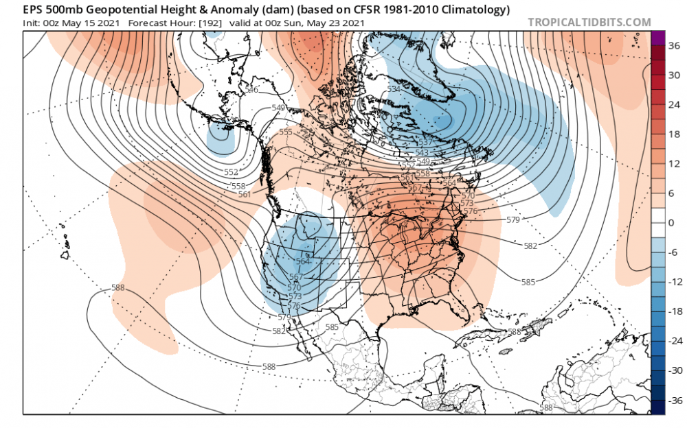
-
Spring 2021 Medium/Long Range Discussion
StormfanaticInd replied to madwx's topic in Lakes/Ohio Valley
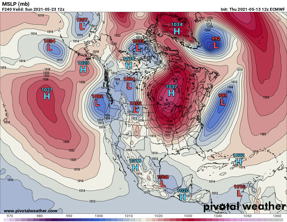
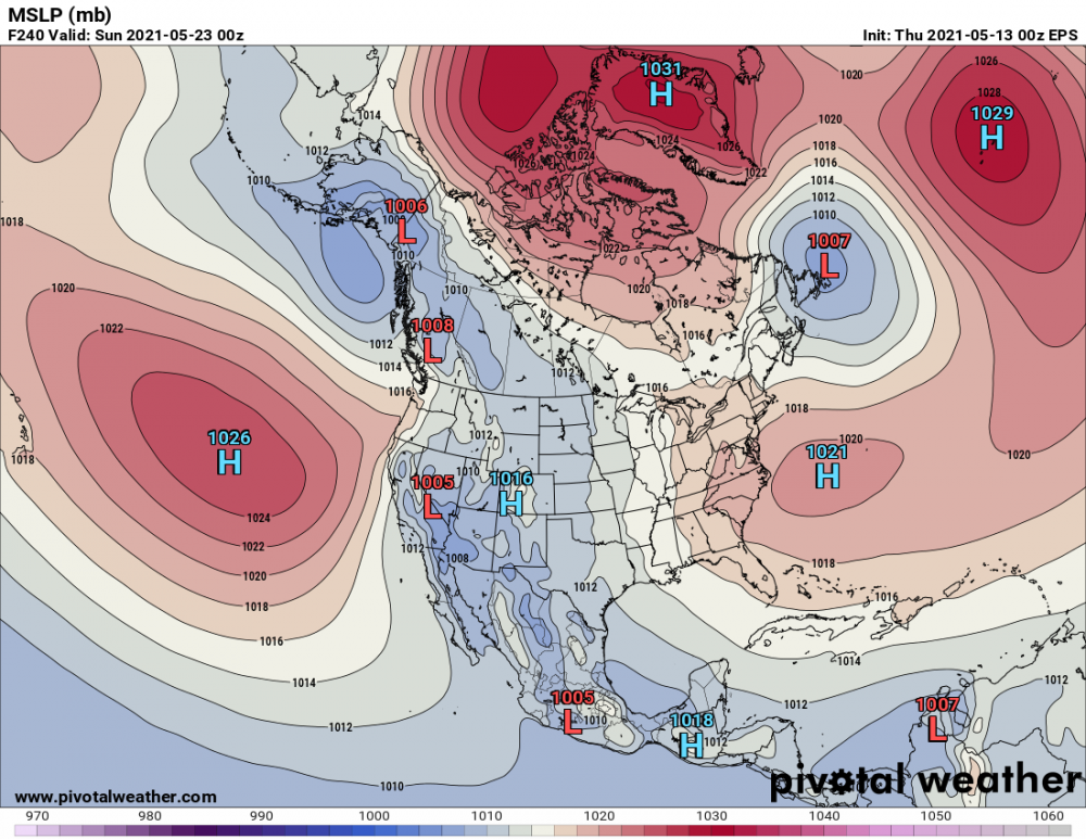
The never ending block -
2021 Short/Medium Range Severe Thread
StormfanaticInd replied to Hoosier's topic in Lakes/Ohio Valley
I agree. This is just weird lol -
Hospitalizations almost down to 30k.
-
I hope you are right. Getting below 10k is going to be a challenge
-
I think mask will now mostly be done with by the summer. Could however make a comeback next fall and winter just out of a abundance of caution?
-
Spring 2021 Medium/Long Range Discussion
StormfanaticInd replied to madwx's topic in Lakes/Ohio Valley
Yeah not a good look. Hopefully it changes. Eps not nearly as bad thankfully lol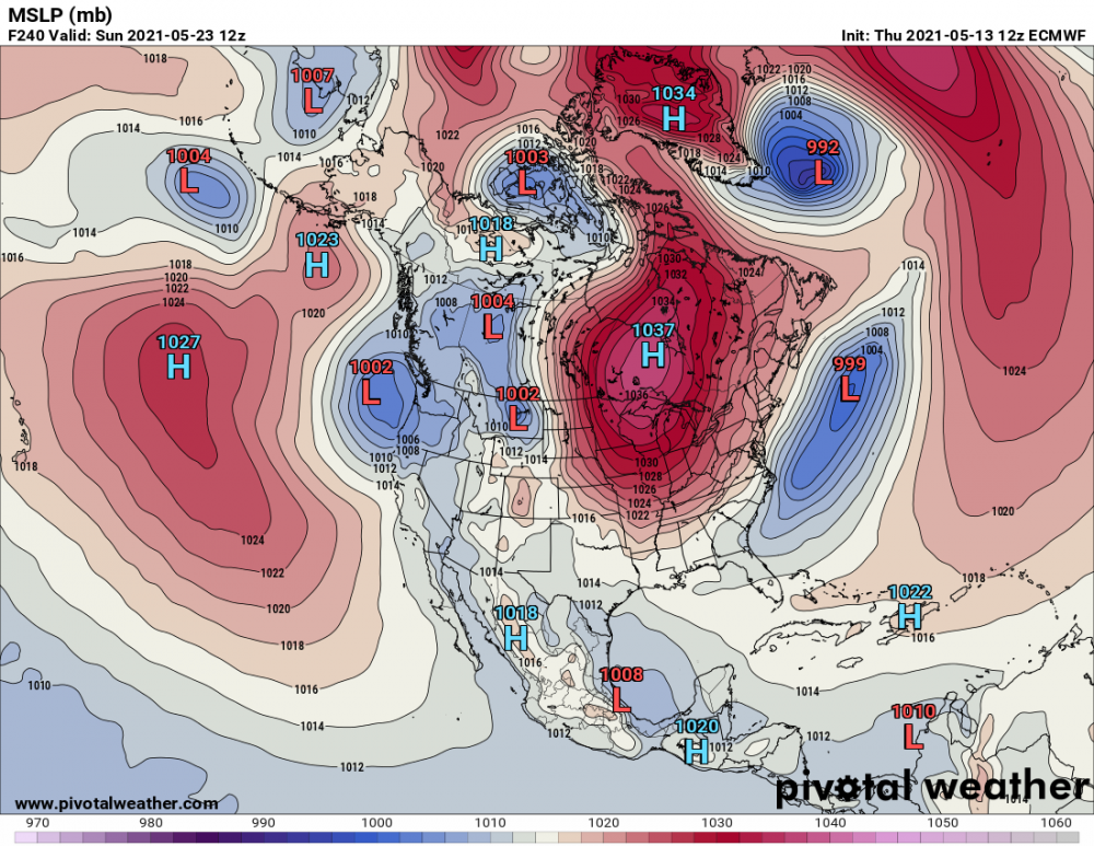
-
Spring/Summer 2021 Banter/Complaint Thread
StormfanaticInd replied to madwx's topic in Lakes/Ohio Valley