StormfanaticInd
-
Posts
2,065 -
Joined
-
Last visited
Content Type
Profiles
Blogs
Forums
American Weather
Media Demo
Store
Gallery
Everything posted by StormfanaticInd
-
2021 Short/Medium Range Severe Thread
StormfanaticInd replied to Hoosier's topic in Lakes/Ohio Valley
-
2021 Short/Medium Range Severe Thread
StormfanaticInd replied to Hoosier's topic in Lakes/Ohio Valley
-
2021 Short/Medium Range Severe Thread
StormfanaticInd replied to Hoosier's topic in Lakes/Ohio Valley
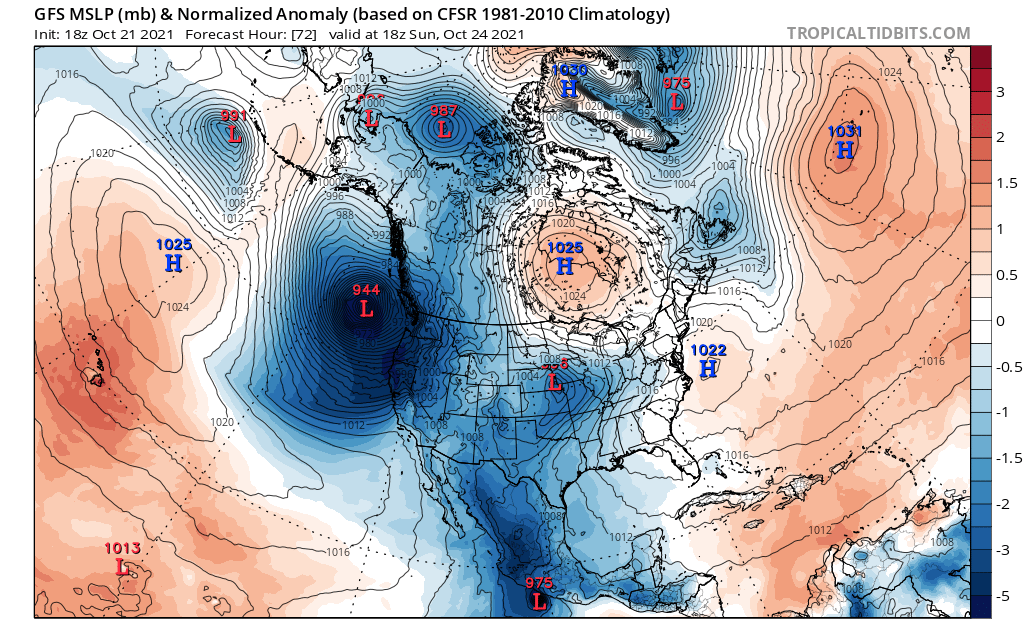
Sunday is looking serious -
2021 Short/Medium Range Severe Thread
StormfanaticInd replied to Hoosier's topic in Lakes/Ohio Valley
I do wonder just how far north that warm front will get with that high pressure to the north. Think the models may be a little too far north
-
2021 Short/Medium Range Severe Thread
StormfanaticInd replied to Hoosier's topic in Lakes/Ohio Valley
I've been noticing that to but am scared to post in these threads anymore lol -
Potential is there for a pretty big fall storm late next week . Will be worth keeping an eye on
-
Would really love snow for the holidays. It's been a while
-
-
When he doesn't let politics get in the way he has a wealth of knowledge that very few meteorologist have. I agree though. Climate change is very real
-
Joe Bastardi is one of our greatest minds even though he can be a bit biased
-
-
-
-
2021 Short/Medium Range Severe Thread
StormfanaticInd replied to Hoosier's topic in Lakes/Ohio Valley
I will say this, Not everyone is on the same level. I am still learning and come to these boards to learn and even debate different view points. Please take into consideration when new comers come and post -
2021 Short/Medium Range Severe Thread
StormfanaticInd replied to Hoosier's topic in Lakes/Ohio Valley
Ok -
2021 Short/Medium Range Severe Thread
StormfanaticInd replied to Hoosier's topic in Lakes/Ohio Valley
Did you not even read my post. -
2021 Short/Medium Range Severe Thread
StormfanaticInd replied to Hoosier's topic in Lakes/Ohio Valley
Impressive but still lots will change
-
2021 Short/Medium Range Severe Thread
StormfanaticInd replied to Hoosier's topic in Lakes/Ohio Valley
Will be interesting to see how this evolves -
Of course. I'm out. You can go ahead and ban me. Lol
-
This look in the winter would be interesting is what I am saying
-
I never said that. Are you always so critical. Jeez
-
Winter may very well start early
-
Looks like cold air is on the move
-
2021 Short/Medium Range Severe Thread
StormfanaticInd replied to Hoosier's topic in Lakes/Ohio Valley
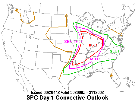
All the ingredients to the potential for widespread moderate to heavy rain and isolated severe thunderstorms on Friday as a cold front slides southeast across central Indiana Friday and Friday evening courtesy of an approaching sharp upper trough and surface high pressure over the Rockies and High Plains. Modest to moderate low level 35 knot jet pointing in from western Kentucky will bring in precipitable water amounts to the 99th percentile for this time of year. This will combine with strong deep layer shear of over 50 knots and low level shear near 50 knots to support the potential of isolated damaging winds despite only weak instability. 115 plus knot upper level jet streak lifting northeast around the base of the trough over northwestern Indiana or northeastern Illinois late Friday supports moderate to heavy rain. Thus, 90 plus percent PoPs look good for Friday with rain moving east into Ohio overnight Friday night and Saturday morning. Look for rainfall of half an inch to over an inch over most or all locations Friday and Friday night. -
2021 Short/Medium Range Severe Thread
StormfanaticInd replied to Hoosier's topic in Lakes/Ohio Valley
Friday is kinda sneaky but I see you.