StormfanaticInd
-
Posts
2,065 -
Joined
-
Last visited
Content Type
Profiles
Blogs
Forums
American Weather
Media Demo
Store
Gallery
Everything posted by StormfanaticInd
-
Very good point
-
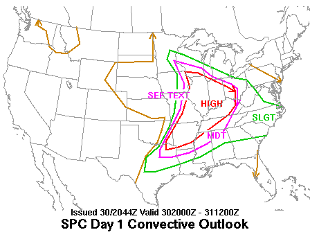
Possible severe weather Monday
StormfanaticInd replied to StormfanaticInd's topic in Lakes/Ohio Valley
Storms getting ready to enter western Indiana -
Possible severe weather Monday
StormfanaticInd replied to StormfanaticInd's topic in Lakes/Ohio Valley
Facts -
-
Possible severe weather Monday
StormfanaticInd replied to StormfanaticInd's topic in Lakes/Ohio Valley
Illinois does seem to be the prime spot for tomorrow -
Possible severe weather Monday
StormfanaticInd replied to StormfanaticInd's topic in Lakes/Ohio Valley
-
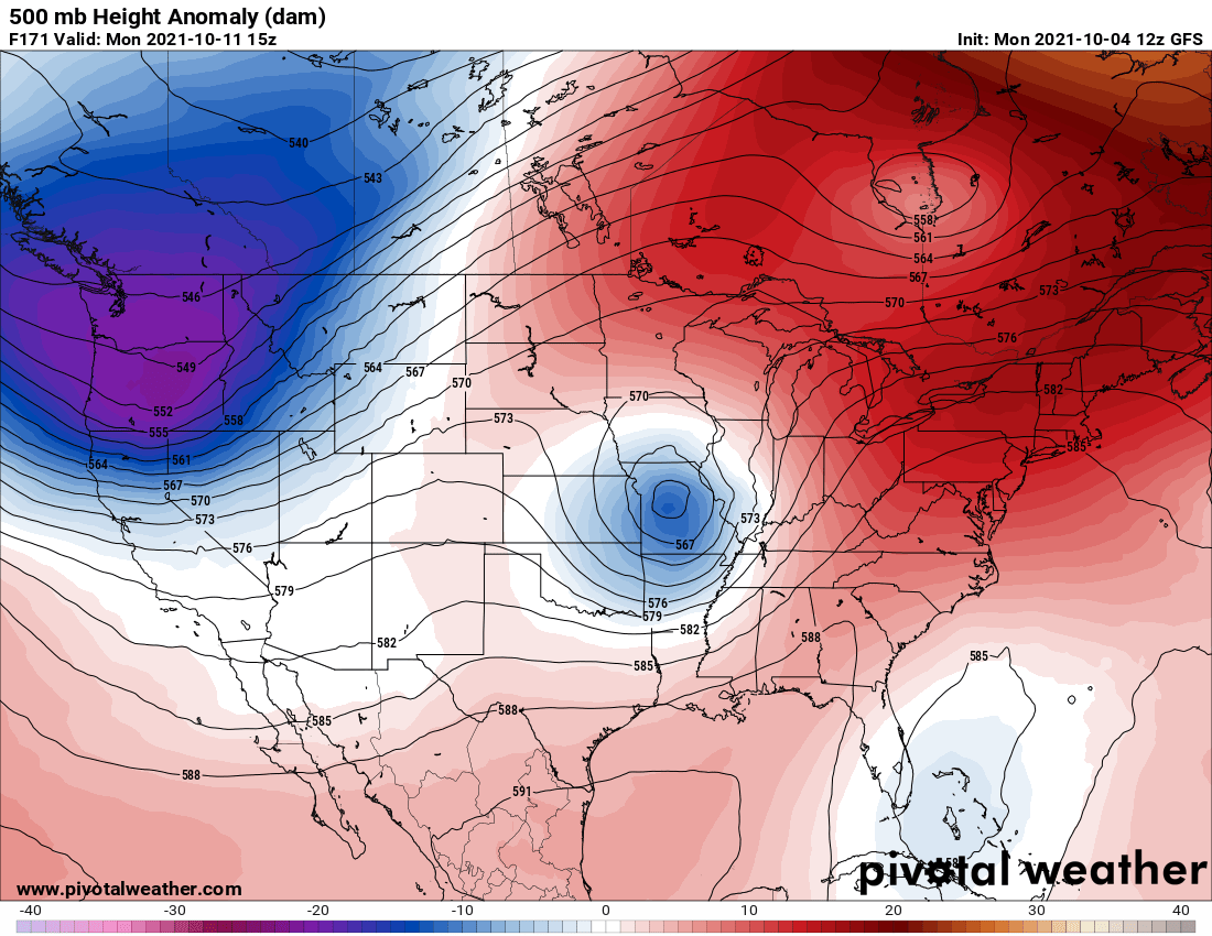
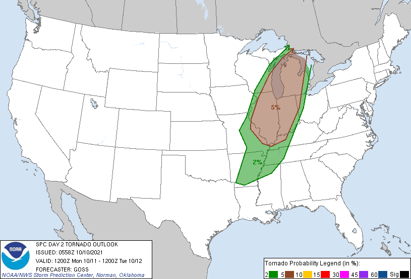
Day 2 Convective Outlook NWS Storm Prediction Center Norman OK 1258 AM CDT Sun Oct 10 2021 Valid 111200Z - 121200Z ...THERE IS A SLIGHT RISK OF SEVERE THUNDERSTORMS FROM THE MID MISSISSIPPI/LOWER OHIO VALLEYS NORTHWARD INTO THE UPPER GREAT LAKES... ...SUMMARY... Strong/isolated severe storms -- including potential for hail, locally damaging winds, and a couple of tornadoes -- are expected to spread from the Mid Mississippi Valley region early, north-northeastward into the Upper Great Lakes through the evening/overnight hours Monday and into early Tuesday. ...Synopsis... An upper trough digging south-southeastward across California and the Great Basin Monday will evolve into a closed low, which is expected deepen and turn eastward overnight reaching the southwestern Utah vicinity Tuesday morning. Ahead of this system, a negatively tilted short-wave trough will be shifting northeastward across the Lower Missouri and Mid Mississippi Valleys during the day, before crossing the Upper Great Lakes region overnight. Meanwhile, ridging will remain in place -- aligned roughly along the Appalachians. At the surface, a cold front associated with the western U.S. trough will sweep across the Great Basin and into the Four Corners states. Meanwhile, a cold front shifting eastward out of the southern Plains toward the Mississippi Valley will weaken with time, while an associated/weak frontal low advances northeastward from Missouri to Wisconsin/Upper Michigan through the period. ...Mid Mississippi Valley northward into the Upper Great Lakes... Showers and scattered thunderstorms will likely be ongoing at the start of the period from western Illinois/Missouri south-southwestward to southeastern Texas, ahead of an advancing cold front. A couple of stronger storms ongoing early could pose local risk for severe weather. After a few hours of local/limited risk, diurnal heating through late morning and into the afternoon will permit sufficient destabilization to allow gradual reintensification/redevelopment of storms, from Illinois to the Mississippi Delta region, then spreading northward and northeastward through the afternoon. Though flow aloft will remain largely south-southwesterly/unidirectional, sufficient speed shear combined with weak veering through the lowest 1 km or so suggests that locally severe/rotating storms will evolve, with threat for damaging wind gusts, along with some hail risk and potential for a couple of tornadoes across a relatively broad geographic region. A bit more uncertainty exists with northward extent, and into the evening hours, into the Great Lakes region. While ascent will spread across this region supporting a continuation of convection through the evening and into the overnight hours, less substantial instability -- diminishing further in tandem with diurnal cooling -- suggests that severe risk will wane gradually from late evening onward.
-
NWS NORTHERN INDIANA "A vigorous upper low will be ejecting up from the southwest during this period, bringing showers and thunderstorms to the area Monday night into Tuesday morning. SPC now has the area in a slight risk for severe storms with this system. This is definitely plausible as a high shear, low CAPE situation. NAM sfc CAPE is less than 2000 J/kg, but bulk shear increases to 50 kts Monday evening. Damaging wind, hail, and even a few tornadoes will be possible."
-
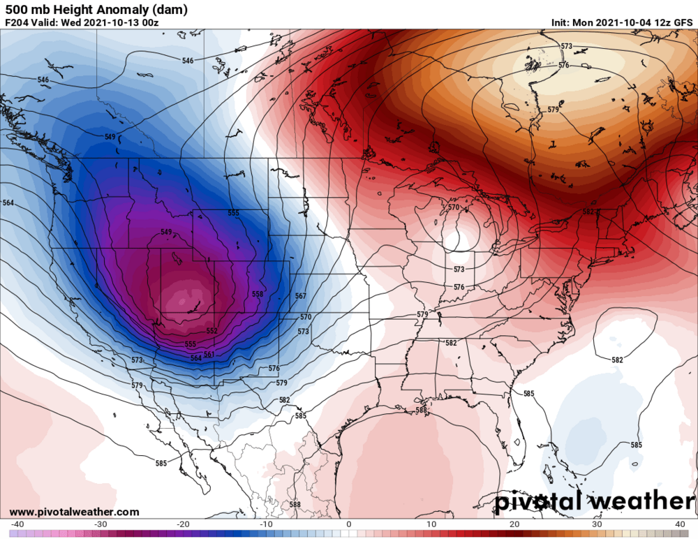
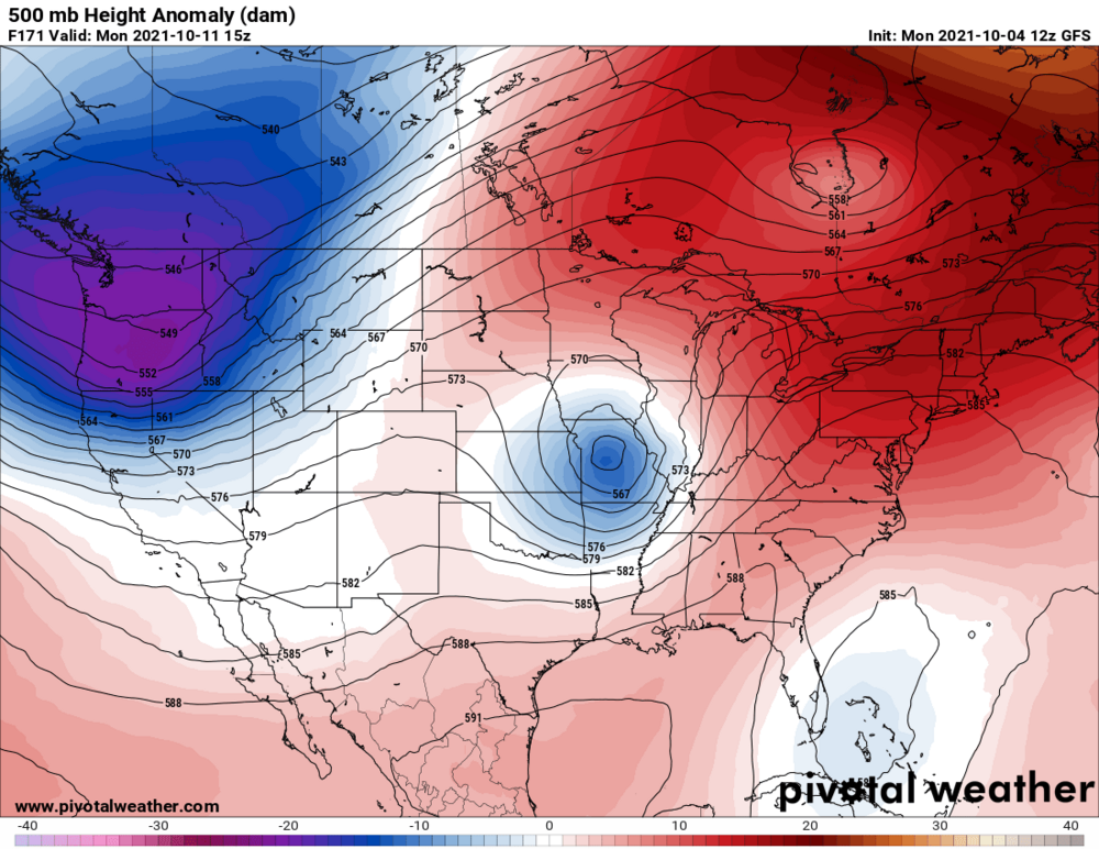
Monday is getting interesting KIND The unseasonably warm weather will continue for much of the upcoming week even as we transition back into a more active regime. A broad upper trough will remain anchored over the Rockies and High Plains through much of the first half of the week...with pieces of energy aloft kicking out downstream of the trough. The first of these pieces of energy will move into the western Great Lakes late Monday into Monday night...helping to generate a surface wave over the southern Plains late Sunday before lifting northeast into Wisconsin by Monday evening. Expect a warm...breezy day for the forecast area Monday with rain chances increasing by late day as a trailing frontal boundary accompanies the surface low and swings into the area Monday night. The overall model suite has come into better alignment on the track of the features at the surface and aloft with just timing differences now present. However...the orientation and track of the system does present some potential for convective impacts across central Indiana late Monday afternoon and evening and a higher ceiling for severe weather as well with modest BL shear and instability present ahead of the front. At this point...potential setting up for predominantly linear convection ahead of the front Monday afternoon and evening with damaging winds. Model soundings though do show a nice amount of directional shear through the boundary layer and storm relative helicities over 200 m2/s2 in a narrow axis ahead of the front which would support rotating updrafts and an elevated risk for tornadoes. This will be something to monitor over the weekend as the parameters associated with this system align further.
-
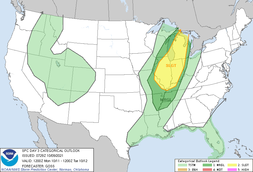
Day 3 Convective Outlook NWS Storm Prediction Center Norman OK 0229 AM CDT Sat Oct 09 2021 Valid 111200Z - 121200Z ...THERE IS A SLIGHT RISK OF SEVERE THUNDERSTORMS FROM THE MID MISSISSIPPI/LOWER OHIO VALLEYS TO LOWER MICHIGAN... ...SUMMARY... Strong/locally severe storms -- including potential for hail, locally damaging winds, and a couple of tornadoes -- are expected to spread from the Mid Mississippi Valley region early, north-northeastward into the Upper Great Lakes into the evening/overnight hours Sunday and into early Monday. ...Synopsis... Western U.S. troughing will continue to dig south-southeastward Sunday, eventually evolving into a closed low surrounded by cyclonic flow which should encompass the entire Intermountain West by the end of the period. Ahead of this digging system, a negatively tilted short-wave trough will eject north-northeastward across the Mid Mississippi and Lower Ohio Valleys, and into the Upper Great Lakes overnight. At the surface, a cold front ahead of the western trough will cross the Great Basin/northern Intermountain region during the first half of the period, reaching a position from the northern Plains to the Four Corners states by the end of the period. Farther east, a frontal wave will shift north-northeastward from Missouri to Wisconsin, while the cold front makes only minor eastward progress through the period. ...Lower Ohio/Mid Mississippi Valley northeastward to Lower Michigan... Showers and thunderstorms are forecast to be ongoing across the Lower Missouri/Mid Mississippi Valley area at the start of the period, with local severe risk possibly accompanying a few of the stronger updrafts. As the upper trough sweeps north-northeastward in an increasingly negatively tilted manner through the day, and a surface frontal wave moves across Missouri to northern Illinois, surface heating beneath steep mid-level lapse rates ahead of ongoing convection through late morning should allow ample destabilization to foster redevelopment/reintensification of convection ahead of the low/front. Given strong flow with height ahead of the upper system, veering gradually through mid levels, shear will support updraft rotation, resulting in scattered strong/severe storms capable of producing all severe hazards. Risk should gradually spread northward, across the Midwest and extending into lower Michigan through the evening and into the overnight hours. ..Goss.. 10/09/2021
-
KIND Models are starting to come to a better consensus for the first low which will bring a line of thunderstorms along a cold (or really, slightly cooler) front across the region from late Monday evening into Tuesday. Tight pressure gradients ahead of this system will bring breezy winds to the area during the day Monday as well. Will have to keep an eye for the potential of severe weather Monday night... seeing CAPE values around 1000 J/kg and bulk shear values around 50. There is still much to be seen and refined until then, but the potential for some embedded severe storms is not out of the question.
-
I think it will be huge this winter. The wildcard of course is the nao
-
Severe weather is looking likely in the Plains and maybe for us to.
-
Would be epic!
-
Brief cool down is coming
-
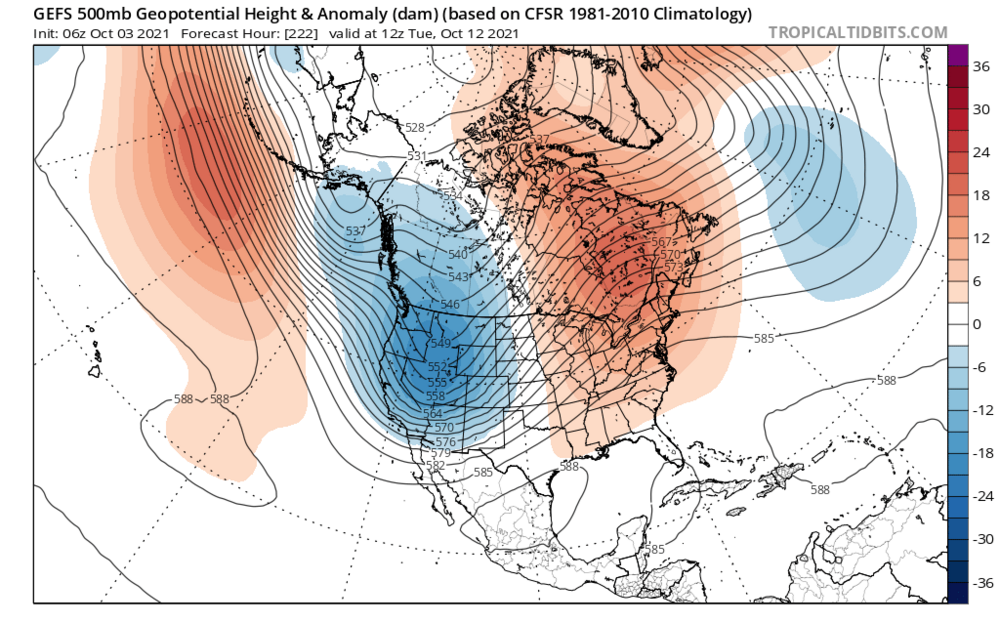
I suspect this trough could push further east and really cool us down for a couple of days before the next storm
-
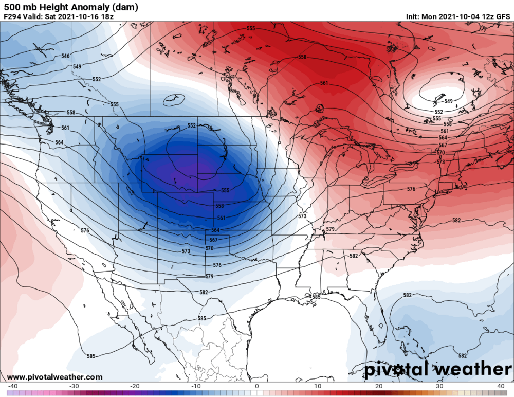
-
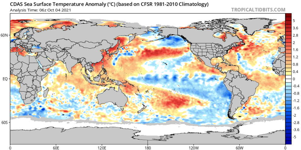
PDO region has really cooled over the past several weeks. **Could** prove to be a negative for this winter.
-
Looks like the recurve of the typhoon will translate into a pretty sizable fall storm with a brief cool down followed by possibly more storms.
-
It is looking extremely active for the next 2 weeks
-
Definitely looking like la nina on the models
-
-
Of course. Weather is a very complicated beast with many moving parts. Any of which can take over. Let's revisit this in 6 to 10 days.
-
Recurve typhoon suggest a trough and possibly some much cooler weather on the way
-
No doubt. Just depends on how strong