StormfanaticInd
-
Posts
2,065 -
Joined
-
Last visited
Content Type
Profiles
Blogs
Forums
American Weather
Media Demo
Store
Gallery
Everything posted by StormfanaticInd
-
-
Spring 2021 Medium/Long Range Discussion
StormfanaticInd replied to madwx's topic in Lakes/Ohio Valley
A bunch of elitist snobs on here. Smh -
Spring 2021 Medium/Long Range Discussion
StormfanaticInd replied to madwx's topic in Lakes/Ohio Valley
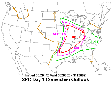
Day 4-8 Convective Outlook NWS Storm Prediction Center Norman OK 0400 AM CDT Wed Apr 21 2021 Valid 241200Z - 291200Z ...DISCUSSION... There is good agreement in medium-range guidance that an upper trough will continue eastward across the lower MS Valley and Southeast on Day 4/Saturday. A warm front should lift northward through the day across parts of central AL/GA and into SC as a surface low develops eastward across the lower OH Valley to the central Appalachians. There is some concern that a strong low-level jet will shift quickly eastwards across these areas, possibly outrunning the better low-level moisture return. Boundary-layer winds veered to nearly westerly should occur as the low-level jet core develops eastward. Still, the increasing low-level moisture, strong deep-layer shear, and some eastward advection of steepened mid-level lapse rates should overlap along/south of the warm front. Any thunderstorms that can form in this regime and remain surface based will pose a threat for all severe hazards. Additional severe convection may develop Saturday afternoon along an eastward-moving cold front. Convection will likely be ongoing Saturday morning given the strong ascent/isentropic lift associated with the low-level jet, and these morning thunderstorms may slow the northward progress of the warm front. Regardless, given latest trends in guidance suggesting a farther north position of the warm front by Saturday afternoon, have expanded the 15% severe area to include more of central AL/GA and southern SC. The upper trough should continue eastward into the western Atlantic on Day 5/Sunday, with rich low-level moisture confined to parts of the FL Peninsula. Given minimal large-scale ascent forecast over this region, overall severe potential ahead of a cold front appears too low to include any severe probabilities. Medium-range guidance remains in fairly good agreement that another large-scale upper trough will advance eastward from the western CONUS to the Plains in the Day 6/Monday to Day 7/Tuesday time frame. The past several runs of the deterministic ECMWF show a very favorable setup for organized severe thunderstorms capable of producing all severe hazards across parts of central TX into OK and southern KS, with moderate to strong instability forecast to overlap rich low-level moisture in the presence of strong deep-layer shear. There has been a consistent enough signal in guidance suggesting a substantial severe threat may develop across these areas next Tuesday to introduce 15% severe probabilities. Greater probabilities may be needed if current model trends continue. Finally, some severe threat may continue on Day 8/Wednesday across parts of the lower/mid MS Valley as the upper trough moves eastward. But, there is too much uncertainty regarding the evolution of convection on Tuesday and the quality of low-level moisture return with eastward extent to include a 15% severe area for next Wednesday. ..Gleason.. 04/21/2021 -
Spring 2021 Medium/Long Range Discussion
StormfanaticInd replied to madwx's topic in Lakes/Ohio Valley
Severe weather season is about to reactivate. -
Really encouraging data the past couple of days. Let's keep this up!!
-
So far the death rate in Michigan hasn't really gone up that much. Vaccines working?
-
April 20-21 late season snow potential
StormfanaticInd replied to Hoosier's topic in Lakes/Ohio Valley
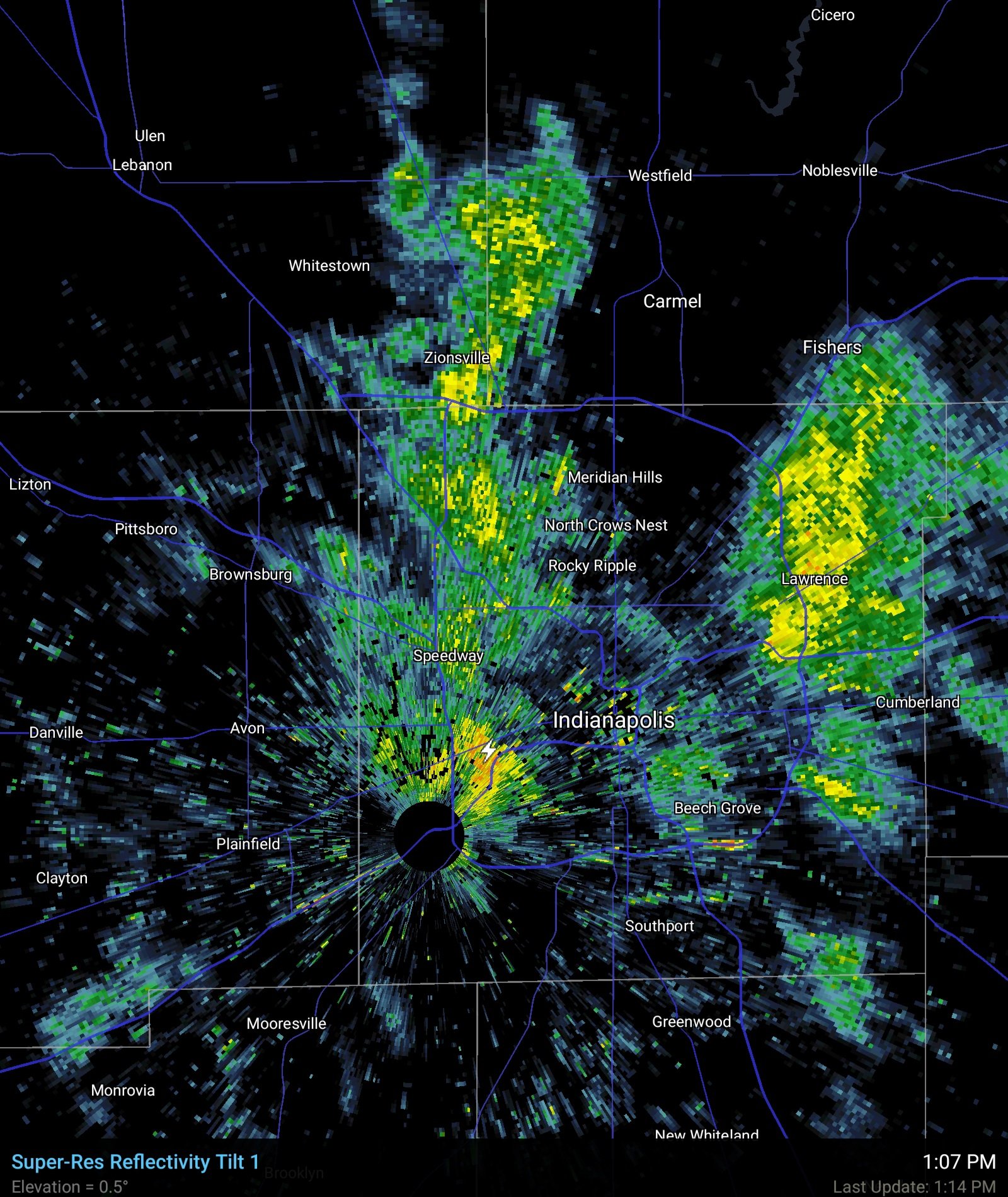
The snow thunderstorms have been incredible today -
More than 315k cases in India today
-
April 20-21 late season snow potential
StormfanaticInd replied to Hoosier's topic in Lakes/Ohio Valley

-
April 20-21 late season snow potential
StormfanaticInd replied to Hoosier's topic in Lakes/Ohio Valley
Thundersnow!!! -
April 20-21 late season snow potential
StormfanaticInd replied to Hoosier's topic in Lakes/Ohio Valley
Visibility literally dropped to almost zero -
April 20-21 late season snow potential
StormfanaticInd replied to Hoosier's topic in Lakes/Ohio Valley
These snow squals are extremely legit today -
April 20-21 late season snow potential
StormfanaticInd replied to Hoosier's topic in Lakes/Ohio Valley
Truly a special event. -
April 20-21 late season snow potential
StormfanaticInd replied to Hoosier's topic in Lakes/Ohio Valley
Really unbelievable to see it snowing this heavily in late April -
April 20-21 late season snow potential
StormfanaticInd replied to Hoosier's topic in Lakes/Ohio Valley
-
April 20-21 late season snow potential
StormfanaticInd replied to Hoosier's topic in Lakes/Ohio Valley
Still coming down good! -
Over 294k cases today and thousands ore dead in Brazil. Its not over yet
-
April 20-21 late season snow potential
StormfanaticInd replied to Hoosier's topic in Lakes/Ohio Valley
Heavy wet snow starting to stick -
April 20-21 late season snow potential
StormfanaticInd replied to Hoosier's topic in Lakes/Ohio Valley
Oz hrrr now loading -
Over a 100k more test but still came in with over 2k less positives
-
-
-
It is amazing what people will believe on social media
-
Vaccination is our only way out of this in a reasonable time. Period