vortex95
-
Posts
730 -
Joined
-
Last visited
Content Type
Profiles
Blogs
Forums
American Weather
Media Demo
Store
Gallery
Everything posted by vortex95
-
January 2026 regional war/obs/disco thread
vortex95 replied to Baroclinic Zone's topic in New England
So two biggies that season? The other on in Dec. Total snowfall you had? -
January 2026 regional war/obs/disco thread
vortex95 replied to Baroclinic Zone's topic in New England
As CoastalWx might say. "WE WEENIE!" It has Blizzard of '93 vibes! 959 mb near Cape Cod? FYI, the lowest non-tropical low pressure in New England is 955 mb at BID, set on March 7, 1932. -
January 2026 regional war/obs/disco thread
vortex95 replied to Baroclinic Zone's topic in New England
The C in Miller C = CoastalWx! I seem to recall some time ago, Miller C was for those TCs that phase w/ an intense baroclinic trough (a la Sandy, Agnes, and Hazel). But I wonder that was just a suggestion, as I can find no documentation on it. There is Miller C-E for snow events for the Mid-Atlantic https://glenallenweather.com/alink/18snow/stormtypes.htm In the Mid-Atlantic In the Miller A description, I don't agree w/ the STJ being weak. A strong STJ is what drives Gulf storms often as there is no PJ involved. One often overlooked classic was March 29, 1984. Blizzard in New England, but other big records set in terms of March heat and tornadoes the previous two days. -
January 2026 regional war/obs/disco thread
vortex95 replied to Baroclinic Zone's topic in New England

-
January 2026 regional war/obs/disco thread
vortex95 replied to Baroclinic Zone's topic in New England
Apply your "English" to it. It worked for this upcoming storm! -
January 2026 regional war/obs/disco thread
vortex95 replied to Baroclinic Zone's topic in New England
Flurries in the Bahamas occurred I think in the mid or late 2000s as well. And it was no where near the level of the Jan 1977 cold. Jan 1977 cold you had the 516 dm 1000-500 thickness into N FL! Incredible. -
January 2026 regional war/obs/disco thread
vortex95 replied to Baroclinic Zone's topic in New England
CoastalWx get ready! -
Does CoastalWx have a PT for the 00z ICON? Kuchera 34" ern MA! UKMET trying to show the same thing!
-
January 2026 regional war/obs/disco thread
vortex95 replied to Baroclinic Zone's topic in New England
It is? 00z ECMWF gives 14" 10:1 to DC, while much of SNE only 5-10"? Not good enough for many! The dreaded 700 dry slot makes it presence know and fragments the event. Not what CoastalWx wants to see! And the UKMET supports the ECMWF. The ECMWF has a solid 1040 mb high over BTV at 102 hr, and it still "loses," so to speak. You now have a very strong 500 system, actually cut off over the Upper MS Valley, and swings from positive to negative tilt quickly, but while moving E over srn Ontario and Quebec. This is not good overall for a focused and intense coastal low. So usually the coastal low takes over once forms, but not in this case. It's becomes one of those wishy-washy things when it can't decide which sfc low (primary or secondary) takes over, so you get something less than stellar. Not a smooth event for sure, and inconsistent S+ areas. This is one of oddest evolutions of a East Coast storm I have ever seen, and we went from a suppressed non-event to this? What else is going to change since we are still just over 3 days from the event starting in New England?
-
January 2026 regional war/obs/disco thread
vortex95 replied to Baroclinic Zone's topic in New England
CoastalWx is too busy doing this! -
January 2026 regional war/obs/disco thread
vortex95 replied to Baroclinic Zone's topic in New England
See my post I just did on Dec 23. 1997. -
January 2026 regional war/obs/disco thread
vortex95 replied to Baroclinic Zone's topic in New England
Dec 23, 1997 is one of the biggest "modern day" busts ev-A for SNE. Another one is Mar 7-8, 2013 (4-8" at best from the ECMWF, and Blue Hill gets 30!"). Another one? CoastalWx super favorite - Dec 9. 2005. 100+ mph gusts? Only in hurricanes do we get that in SNE! And reliable reports in Andover MA area of SNOINCR 9! TS+ all over the place. Dec 23, 1997 the following day BOS Herald front page headline - "THEY BLEW IT!" and have all the OCMs on the previous evening photos (Harvey Leonard was on vacation, so they did not show his photo). Typical Herald w/ a cheesy headline (it goes way back, Sep 13, 1988 for HU Gilbert front page headline "KILLER'CANE!!!" Your Acton SNOINCR 7 jibes well w/ the SNOINCR 8 in Ayer MA. Nice to have verification! The low itself was rather small and not that deep (1000 m I think) And there was a little bubble high over nrn ME, which likely played a role in keeping it just cold enough. This was a watershed event in some regards. The following year the the SNE Wx Confernce, WFO BOX talked about DGZ. Totally new concept, at leas to me at the time. Not all snowflakes are created equal! -
January 2026 regional war/obs/disco thread
vortex95 replied to Baroclinic Zone's topic in New England
Trend is your friend!? -
January 2026 regional war/obs/disco thread
vortex95 replied to Baroclinic Zone's topic in New England
12z GFS 1" DCA, 18z GFS 13". What a piece of crap. And had zippo for SNE 12z and now 18z trying to do some weenie lagging trough thingee for ern MA. CoastalWx will be pleased!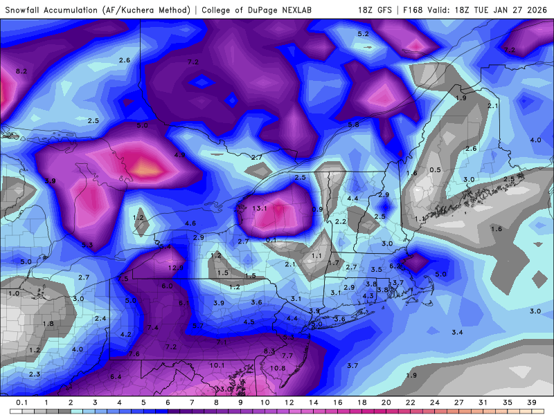
-
January 2026 regional war/obs/disco thread
vortex95 replied to Baroclinic Zone's topic in New England
That's when Machester-by-the-Sea had the weenie OES 23"? -
January 2026 regional war/obs/disco thread
vortex95 replied to Baroclinic Zone's topic in New England
-12 to -18 C. That sound right, Perhaps I was thinking the HGZ (hail growth layer) or the ideal charge layer for LTG for mixed phase! -
January 2026 regional war/obs/disco thread
vortex95 replied to Baroclinic Zone's topic in New England
-12 to -16 C in the DGZ is key for the big dendrites, but where are the good UVVs and does high RH overlap? It's tricky. I recall a long-duration event in Jan 1994 w/ sfc temps in the single numbers at the sfc much of the time in ern MA, and it was largely sand. I guess it can be *too* cold at times for fluff! -
January 2026 regional war/obs/disco thread
vortex95 replied to Baroclinic Zone's topic in New England
"lost in the trenches of forecasting an upcoming event... this definitely feels like we're turning a corner in SNE compared to last 4 years." Does CoastalWx agree? -
January 2026 regional war/obs/disco thread
vortex95 replied to Baroclinic Zone's topic in New England
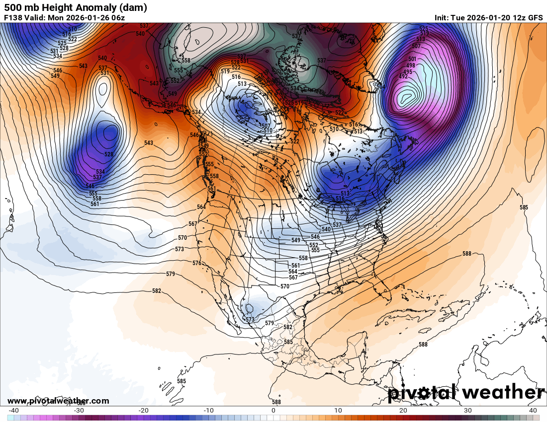
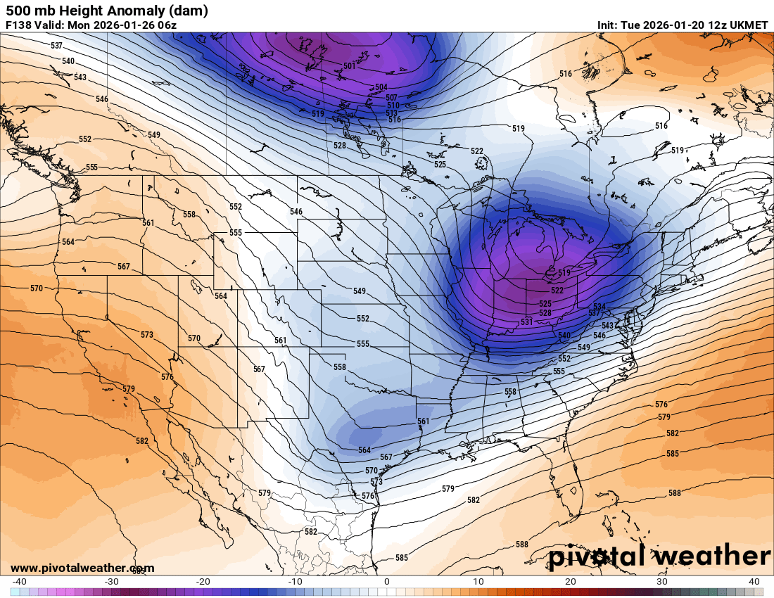
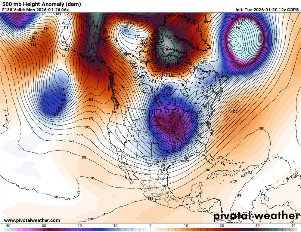
I did not read back on all the posts in the last 18 hr on the upcoming storm, so pardon the repetition or if I state the obvious already said. First, "hope floats" for CoastalWx seems to working. He has consensus on his side at least!. LOL Second, wow, what a change from ydy on all global models. The lagging 500 s/w in the Midwest is *much* stronger now, and complicates things a lot. Perhaps this is the "English" CoastalWx was relying on for the TICK to the N? So it may be the initial sfc low off the coast is more of a flat wave, and does not push the baroclinic zone too far offshore, and then rear backup upper-level support pulls things back for a new sfc low. 00z ECMWF was quite aggressive w/ this, but the 12z backed off. GFS now flatter than a pancake, but GDPS and UKMET both suggest what the ECMWF has been doing. 11 of the 20 12z GEFS members show a hit for SNE. So it appears it all hinges on what the lagging 500 s/w does in terms of depth and how far S it can dig. You can clearly see the differences in the 138 hr 500H anomalies I attached from the 12z GFS/ECMWF/GDPS/UKMET. Looking at the pattern across NAMR. There are some problems. First, the wavelengths are too long, and the western ridge much too far W. Also, there is little in the way of s/w ridging in the NATL. So the Midwest trough is more or less a straight shooter W to E. It goes from positive tilt in the Great Lakes to neutral farther E, but then just stays neutral w/ the trough neither weakening or deepening as it moves across the NEUS. Even so, that does not mean CoastalWx should panic. You don't always need a classic pattern/setup to get a weenie event (see March 6-8, 2013 and a few others from the mid 2010s). Slight changes can be huge in this case for sensible wx in a region/area.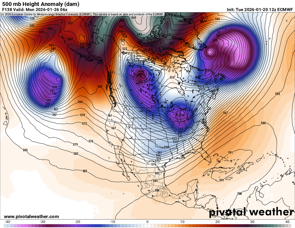


-
January 2026 regional war/obs/disco thread
vortex95 replied to Baroclinic Zone's topic in New England
And it was quick hitter in much of MA/RI. I got about 15" in 8 hr in Woburn Snow began not long after midnight and it was clearing out by 9am! -
January 2026 regional war/obs/disco thread
vortex95 replied to Baroclinic Zone's topic in New England
That evening when I heard on the wx radio that LGA has TS+, I said, "no way it can be tucked that far NW and not get BOS!!!" -
January 2026 regional war/obs/disco thread
vortex95 replied to Baroclinic Zone's topic in New England
CoastalWx applying "English" to TICK the weekend storm N!? UKMET does so and GDPS is tryin'. GFS and ECMWF say no, but a "MIDLO" blockbuster for the Mid-Atlc. This is quite interesting. There is literally nothing at 500, at least I can't find anywhere close to the sfc low. When it is just off Delmarva, the flow close and over it is actually a bit anticyclonic! The trough/vort is way W in MKE-DSM area. I don't think that vort here is driving it. It's a classic Miller A "bottom-up" system. Strong from sfc-850, but MEH above that. The Feb 11, 1983 blockbuster was like this. CoastalWx LUVs this one b/c it was fcst NOT to hit SNE, and a big surprise. South Weymouth NAS had TS+ and BDL SNOINCR 5. Also SNOINCR 5 at ABE and LGA had TS+. New all-time 24 hour snowfall records were set at PHL, CXY, and ABE. Max amount of 35" at Glengary WV. This event was not a deep sfc low, about 994 mb at its closest approach to SNE, and the weekend storm looks similar. Also, like Feb 11, 1983, a very cold Arctic air mass was in place over the NEUS, and suppression of the storm track was a big fcst issue!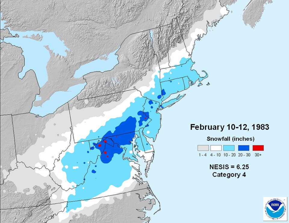
-
Rise of the Machines: January 18-19 Winter Storm Obs Thread
vortex95 replied to WxWatcher007's topic in New England
I would not put too much stock in Logan's record no 6" single snowstorm streak. Why? 1) The measurement hasn't always been at Logan. It used to be a bit more inland before the airport was built, and Logan is about the *worst* location for BOS city snow since it is surrounded by ocean on 3 sides (doesn't work well for true "city" temps either). Even in recent decades, it always hasn't been at Logan Airport, Starting the mid-90s for a number of years, as one example, it was taken 1 mi away to the N by a trained spotter. 2) The observer measurements have not always been up to par. Too low, too high, not brushing off every 6 hr or more than once every 6 hr, and gaps in observations of snowfall as well. This is not unique to Logan, and some major airports have great observers. I am just pointing out the caveats/shortcomings when it comes to BOS 6" snowfall gap record. 3) When the NWS Modernization occurred in the 90s, once ASOS was installed at climate sites, which are almost always at airports in the U.S., many routine snowfall observations where lost, and some came back, but snowfall was not considered a high priory overall. 4) Of all the major wx parameters we measure, snowfall is the hardest and least accurate due to many factors. Here is an article that covers some of the issues: https://news.ucar.edu/14009/snowfall-measurement-flaky-history The point is Logan had 5.3" from this event. Falling short of 6" by less than an inch is well within range of error, esp. for wet snow that compacts easily, and considering the overall challenges of measuring snowfall and long-term records not consistent or subpar at times. -
Rise of the Machines: January 18-19 Winter Storm Obs Thread
vortex95 replied to WxWatcher007's topic in New England
Perhaps the sfc low deepened a bit more than expected or the more solid NNE gradient occurred earlier as the storm pulled away. Given the borderline BL temps and no high pressure to the N, small changes to things can make a big difference locally for sensible wx like snowfall. Non-standard setups can do odd things, and the unexpected, esp. b/c we don't have many or any past events to reference. And take note how wishy-washy both the global and meso models were leading up to this event, so that suggests a non-standard setup/pattern that the models struggle w/. Just re-enforces how weird this snow season has been. But what *should* matter to CoastalWx is the end results. But noooo, he probably pines still for the Bliz of '05 all over again! -
Rise of the Machines: January 18-19 Winter Storm Obs Thread
vortex95 replied to WxWatcher007's topic in New England
That's a new modifier concerning snowfall -- "violently" beautiful??? Now everyone knows why I call CoastalWx the super UBER snow weenie! He makes up phrases to describe his ecstasy!