Ed, snow and hurricane fan
-
Posts
2,133 -
Joined
-
Last visited
Content Type
Profiles
Blogs
Forums
American Weather
Media Demo
Store
Gallery
Everything posted by Ed, snow and hurricane fan
-
 Austin has ice on the ground Tuesday into Wednesday on all the high res except the FV3, and College Station, while no ice verbatim, gets w/i a couple of degrees of freezing on NAM. DFW is certainly cold enough, the issue would seem to be how much precip. NAMs setting up the icing boundary near I-35 in C. Texas, No ice in Houston, but 2 to 3 inches more rain, mainly N of I-10, near where DW Hooks (very near TIAH doppler) has had just over 3 inches the last six hours. Interesting week ahead.
 -
I don't think NYC area ever approached -10F when I was a kid.
-
12 km NAM says no classes at UT on Wednesday.
-
Warm front got from VIC to SGR in two hours, I think the tornado warnings so far around Houston have been in cells too far into the cold sector to produce, but warm front is now near I-10 in Harris County, or real tornadoes, not just warned tornadoes, seem possible. The cell near Tomball was 20 miles into the cold sector, but the tornadic signal on TIAH radar was real.
-
NAMs coming closer, but still only the HRRR that is getting actual downtown Houston into the warm sector. 13Z HRRR actually has the warm sector a smidge farther S than earlier runs. I-10 and S
-
Watching Twitter for the 1 km nest- I wouldn't know where to find it.
-
Not much has changed, SPC has enhanced for tornado for S. Houston metro. Alvin, TX 18Z forecast sounding. Enhanced risk, from just S. of Houston, extends NE to Pensacola area.
-
Tuesday afternoon- warm sector doesn't quite get to MBY just N of Houston in Harris County (Zero SBCape), but S of I-10 and E of I-45 (not a big area, mostly just Galveston and Brazoria counties) does get into the warm sector, and while CAPE in the warm sector is only about 500 J/Kg ahead of the line, 700 (m/s)^2 and 80 knots shear produces an STP of 4. Despite IAH and DFW being cold sectored 3km and 12km NAM, sim radar shows impressive looking thunderstorms for DFW early afternoon and IAH late afternoon. Only take a small bump N of the surface low to put IAH on the warm front.
-
Getting a weenie tag from Ant would make my life complete.
-
Houston ice storm, with no school. This is the one 11 day GFS forecast that verifies perfectly this year. About 0.3 to 0.5 inches of QPF. Mostly sleet but with freezing rain to start and snow to finish. Mid 20s during precip. Only fly in the ointment is no rain to wash anti-ice chemicals off the bridges and overpasses, which isn't all bad, ambulances need to travel. But ice on untreated surface streets (TxDOT only does bridges/overpasses), I'm already planning my day off with the children. cc: @MJO812
-
Winter 2022/23 Banter Hangout
Ed, snow and hurricane fan replied to Chicago Storm's topic in Lakes/Ohio Valley
Down here mid 40s dewpoints aren't juicy, not even in January. -
TorWarns at the moment in Texas and Arkansas
-
Mid week East Texas severe threat.
-
January 15-16 2023 Storm Potential
Ed, snow and hurricane fan replied to Baroclinic Zone's topic in New England
Speaking of Canadians- that is a cool forecast satellite. -
January 2023 Obs/Discussion
Ed, snow and hurricane fan replied to Torch Tiger's topic in New England
Analogue? -
January 2023 Obs/Discussion
Ed, snow and hurricane fan replied to Torch Tiger's topic in New England
Is -5C cold enough for snowmaking? My impression from 40 years ago up there that wouldn't be cold enough. Do resorts in Alps even have equipment? -
January 2023 Obs/Discussion
Ed, snow and hurricane fan replied to Torch Tiger's topic in New England
GFS 1.16 PW, is that a BOS sounding record for January? HOU wasn't much over that being 80F this weekend. Edit- after the 15F Christmas Eve, which killed a lot of tropical plants that survive our 'usual' (almost every Winter) upper 20s freezes easily, back to a warmer than usual/near daily records weather down here. -
January 2023 Obs/Discussion
Ed, snow and hurricane fan replied to Torch Tiger's topic in New England
Argentinean Monk Parakeets. Escaped pets that build communal nests which keep them warm enough to survive Winter. https://brooklynparrots.com/ -
Atmospheric river model site from UC San Diego. https://cw3e.ucsd.edu/iwv-and-ivt-forecasts/#IWV
-
January 2nd and 3rd Severe Weather Threat
Ed, snow and hurricane fan replied to DanLarsen34's topic in Central/Western States
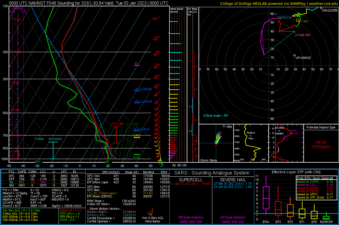
3 km NAM as sun sets in Fayette County, Arkansas. Or Miller County, just to the W, which is a 'wet' (alcohol allowed) county. Cross the river from Fayette County to buy beer. Bit N of best instability, but outrageous low level spin.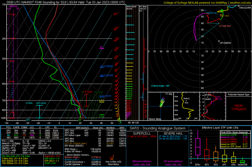
-
High school chemistry, or maybe physics, how ice skates work, the pressure of the weight of a human on very small surface area skates melts the ice, and the thin coating of water, what the skater glides on. We had test questions, with serious math, about ice skating. (Jesuit high school) The weight to surface area of a car is a lot lower. Is ice slippery to drive on in Fairbanks or Siberia?
-
January 2nd and 3rd Severe Weather Threat
Ed, snow and hurricane fan replied to DanLarsen34's topic in Central/Western States
3 km NAM sounding just ahead of a supercell on the model near or just E of Huntsville/Madisonville area. Boatloads of low level helicity. Hints of more semi-discrete further W (towards DFW) ahead of the Pacific front as well.
-
January 2023 Obs/Discussion
Ed, snow and hurricane fan replied to Torch Tiger's topic in New England
SW flow event code for snow changing to rain? Asking for myself.