

wizard021
-
Posts
413 -
Joined
-
Last visited
Content Type
Profiles
Blogs
Forums
American Weather
Media Demo
Store
Gallery
Everything posted by wizard021
-
Really close on gfs wow.
-
Pa Pay attention to the height rises over the tenn valley.. that is how you get a Miller a storm.
- 373 replies
-
- 2
-

-

-
- heavy rain
- wind event
- (and 2 more)
-
Monday could turn into a snow event, with the first one being a scraper.. more room to amplify the remnant cutoff low.
-
Well I am not telling everyone to disregard the NHC, it is just my personal preference to not listen to them. No hard feelings.
-
115 kt fl wind = 100 to 105 kt at the surface. Cat 3 all likelyhood .
-
High shear on approach to gulf coast and cooler waters will weaken this quick. Lili 2002 analog
-
Icon and ukmet form the wave in the caribbean moving west.
-
ukmet has a new td in 5 days.
-
Gefs para is active
-
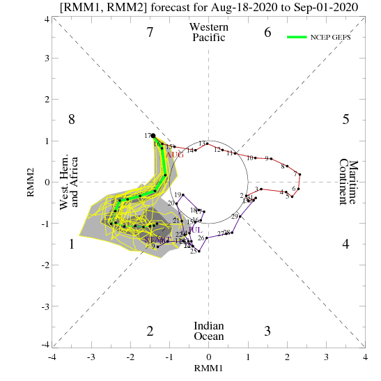
Phase 8 to 1 then maybe cod which still could fire more storms. Ecmwf has 2 robust waves after laura and marco.
-
https://www.cpc.ncep.noaa.gov/products/precip/CWlink/MJO/CLIVAR/ecmm.shtml. next 2 weeks primed.
-
No. Ukmet gfs match.
-
Its neutral endo. People r drunk today.
-
phase 8 to 1 is favorable. You get most hurricane in phases 8 to 2.
-
-
Wrong . Phase 8 to 1. Look at the chart .98l is moving into a rising atmosphere not sinking . Don't focus on tutt lows they come and go and can act to enhance outflow.
-
Dude get a clue there is always tutt lows . It is about how the systems interact with them. Mjo is phase soon.
-
This is a classic s florida strike pattern. Trough split, allowing ridge to build explosively . Ecmwf has a phantom trough recurve like with Ike it showed.
-
-
Gfs still makes landfall with future 98l in Brownsville with a cat 1?
-
Could be , but with the amplified mjo moving in, have to think conditions will be as favorable as the other non gfs models have it.
-
Ukmet is north , cmc is middle ground and gfs is furthest south. Gfs has been having wild swings on intensity from 00z to 06z to 12z.
-
https://tropicaltidbits.com/analysis/models/gem/2020081712/gem_shear_watl_29.png Light shear, mjo pulse, and warm waters will easily lead to a strengthening hurricane as depicted here. Gfs is tossed as of now.
-
Cmc/Ukmet both north of the islands and intensifying toward south florida or keys.
-
Based on the globals west path is likely, how far north initial movement tied to faster or slower formation. I am sticking with the Ukmet, likely north of islands and west track into florida as a cane.
