csnavywx
-
Posts
5,729 -
Joined
-
Last visited
1 Follower

About csnavywx

Recent Profile Visitors


-

2026-2027 Super El Nino
csnavywx replied to Stormchaserchuck1's topic in Weather Forecasting and Discussion
Record warm water volume this time: -
2026-2027 Super El Nino
csnavywx replied to Stormchaserchuck1's topic in Weather Forecasting and Discussion
Yes. The keystone paper you're looking for is here: Influence of the state of the Indian Ocean Dipole on the following year’s El Niño | Nature Geoscience Made a note of it last year, but at that point it looked initially like a moderate event was most likely. wxchris on X: "The recent record/near record -IOD is collapsing. Warm water is sloshing east towards the WPac, putting the fully mature Nina on borrowed time. Expect whiplash. https://t.co/rZb3PjimBU" / X -
If I had to guess, your nose is probably picking up a bit of peat+muskeg burning mixed in there. People have no idea how much worse it can get once the main shield peatlands and mixed peat/forest stands start burning. Gonna guess winter is going to be extremely warm up there this year and tilt the dice towards early warming/drying of those areas into next summer.
-
2026-2027 Super El Nino
csnavywx replied to Stormchaserchuck1's topic in Weather Forecasting and Discussion
The large kelvin wave around 140W is probably the one to do most of the heavy lifting in a few weeks. Would expect subsurface anoms to increase past +10C here soon. Getting a little more tricky to find them when they get generated since the thermocline is pretty depressed already, but at least this one is still pretty visible. -
2026-2027 Super El Nino
csnavywx replied to Stormchaserchuck1's topic in Weather Forecasting and Discussion
Yes, at first blush it's not a disaster for the SE. But last couple of strong Ninos makes it clear it may not be that cut and dry either. Either way, I'd bet on wet. -
2026-2027 Super El Nino
csnavywx replied to Stormchaserchuck1's topic in Weather Forecasting and Discussion
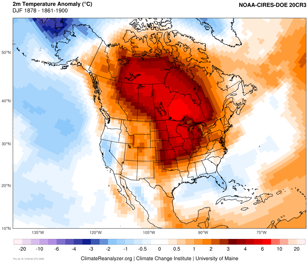
Here's the continental composite using the 1861-1900 average to detrend. Note that a simple detrend, while helpful, still assumes that SST changes since then will scale linearly in terms of forcing (almost certainly not going to be the case). Nevertheless, the overall pattern makes it clear that the continent will mostly suffer from high frequency intrusion of downslope events, enhanced by anomalous moisture transport and a surplus moist static energy.
-
2026-2027 Super El Nino
csnavywx replied to Stormchaserchuck1's topic in Weather Forecasting and Discussion
Leaning towards it getting even stronger than the 1877-78 event, much less the 97/98 one, but that depends on whether or not we get any sort of pause in the WWB train/standing wave. That event was exotically warm across most of North America through the vast majority of the winter. In fact, farmers were planting their crops in Minnesota in February (yes, really). Article covering that from Mark Seeley out of the University of Minnesota: 1878 El Niño saw crops planted in February Texas itself was mild (relative to normal at the time) and very wet into the fall and especially winter. The current event you're suffering through is a side effect of a persistent rossby wave train that has set up in (at least in part) due to the response to the forcing induced by the developing Nino, but ENSO relationships in the summer are weaker and it's also partly just bad luck. -
2026-2027 Super El Nino
csnavywx replied to Stormchaserchuck1's topic in Weather Forecasting and Discussion
'97 loses some steam from here over the next month and as you point out, there's another large KW on the way, so would expect these two events to swap positions with respect to max anomaly temps. -
2026-2027 Super El Nino
csnavywx replied to Stormchaserchuck1's topic in Weather Forecasting and Discussion
We're at the point where this event catches up to '97 and passes it handily. -
2026-2027 Super El Nino
csnavywx replied to Stormchaserchuck1's topic in Weather Forecasting and Discussion
Case in point. We were slightly behind 97/98 with thermocline depression. That year took a break in July before turning the turbojets back on. This one doesn't appear to be taking a breather.
-
2026-2027 Super El Nino
csnavywx replied to Stormchaserchuck1's topic in Weather Forecasting and Discussion
Early trade wind pattern in this event certainly looked like 72-73. Then tilted more towards 97-98. It's a souped up version of those older canonical events, imo, if superimposed on a warmer background state. Problem is I think the warm pool is coming even further east than '98 did (that event got to about 150W) and it will drag everything else into resonance with it, so makes a straight shot comparison more muddled. -
Yeah, would need a turbo +AD/-AO to counter how well it's gone in the main basin so far this year. Probably not getting that until next year (post-peak Nino).
-
2026-2027 Super El Nino
csnavywx replied to Stormchaserchuck1's topic in Weather Forecasting and Discussion
Was referring to hoping for a moderate Nino event initially. Quickly became evident in March that wasn't going to be the case. -
2026-2027 Super El Nino
csnavywx replied to Stormchaserchuck1's topic in Weather Forecasting and Discussion
This year was basically fine. Just need to keep it to a low simmer and slowly reconstitute the warm pool over time. Maybe throw in a cooler NATL spell that can reinforce trades and pop an actual CP Nino or two. We're at least very very likely to see some very strong Arctic warming into early winter '27-28 (response up there tends to lag lower latitudes quite a bit). -
2026-2027 Super El Nino
csnavywx replied to Stormchaserchuck1's topic in Weather Forecasting and Discussion
The entire warm pool is being discharged. Not only is there not any significant trade resistance this time around (remember '15?), quite a bit of activity has been ongoing away from the equator in addition to being on it. Modeling has steadily been playing catchup since the start of the event as it gradually incorporates all of the additional accumulated wind stress and eckman transport. This will be a colossal east-based event and trying to short it or fade it or talk it down is a fool's game. Look I get it, I like snow too and very early on (Dec/Jan) I was hoping we'd get a moderate event with the indo-pacific warm pool still intact. But that ain't happening. Better off cheering for some exotically warm winter up north that forces some weirdly favorable wave breaks downstream and south. Or save your emotional capital for the backlash Nina period. These big Ninos do have a tendency to cause climate regime shifts, so it's not always a bad thing once the event clears.