MN Transplant
-
Posts
17,845 -
Joined
-
Last visited
Content Type
Profiles
Blogs
Forums
American Weather
Media Demo
Store
Gallery
Everything posted by MN Transplant
-
Almost comical at this point. 35.6 for my low. Even DCA in the river went lower. I know I talk about it occasionally, but the elevation/cold air drainage/inversion thing is amazing. This is my frost-free backyard with an extremely frosty soccer field in the background. The difference in elevation is ~30’.

-
Need that one in Wilmington, early transfer.
-
I think it’s almost all elevation/inversion. The stations that aren’t on the Tyson’s “ridge” were down in the 30/31 range. The ones that are were in the 35/36 range. When I walked down the hill to drop the kid off at school it looked like a different world, and that is like a block away.
-
A frosty 36.0. I’ve been running parallel to DCA this week.
-
I appreciated the Fairfax County schools email. Got into the Tysons one next week.
-
Missed at BWI by 1. DCA not even close.
-
My hill doing work. 37.8 for a low. Very unlikely that it’ll freeze this week.
-
Plus, you get a virtual bye week win against my Vikings.
-
36.3 on my hill in Falls Church. My brother just moved to Middletown, MD (just W of Frederick) and is down to 26.6!
-
One third down conversion. One!
-
East of DC/West of the Bay did well with that N/S oriented band.
-
The thin line doesn’t have any wind punch to it. I’m guessing any chance to mix down is going to have to happen ahead of it. Amazing how October was bone dry until the final week, and will now go into the books as above normal in many spots. Soaked out there.
-
The other thing about it is that our trees are more conditioned to stronger W/NW winds. Makes me wonder if we could get some damage with the E/SE winds if the gusts do kick up into the 40s.
-
Breezy this morning already. Makes me wonder if the HRRR/NAM are onto something with mixing down some good gusts when the heavier precip gets here.
-
Bringing this over to the obs thread. As of right now, the forecast is for a top-15 crest all-time on the Potomac at DC.
-
The gusts on Cape Cod are nuts. Some 100mph+.
-
Your climo stat of the day. It has been 45 years since DCA has set a record low in the months of September or October.
-
Ha. Tells how dry the rest of the months was. 2.38” total.
-
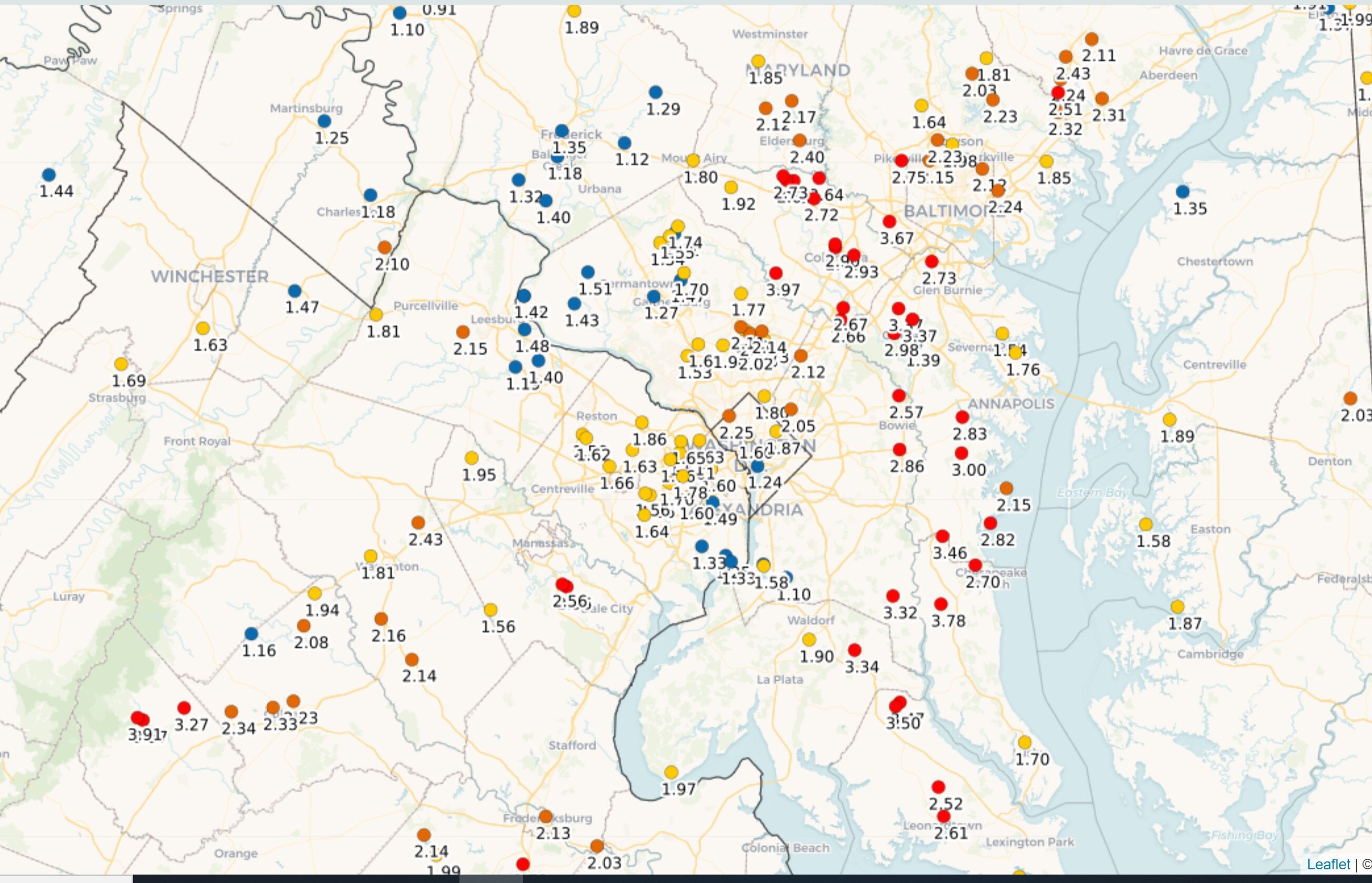
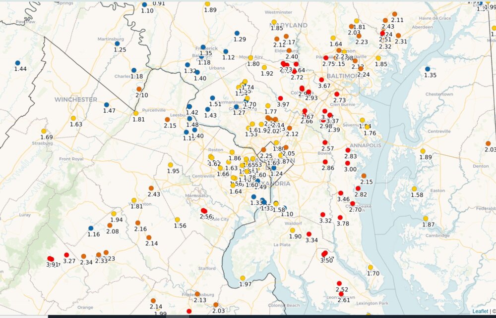
1.72” so far. Even more just west of the Beltway.
-
2021 Mid-Atlantic Severe Weather - General Discussion
MN Transplant replied to Kmlwx's topic in Mid Atlantic
80/60 at DCA. 79.2 here -
Have you met anyone on this board?
-
2021 Mid-Atlantic Severe Weather - General Discussion
MN Transplant replied to Kmlwx's topic in Mid Atlantic
12z NAM 3k is a bit more frisky than prior runs. Both the NAM and HRRR indicate that there may be a set of cells out in front of the main line, which is pretty common around here. -
2021 Mid-Atlantic Severe Weather - General Discussion
MN Transplant replied to Kmlwx's topic in Mid Atlantic
Feels sickly humid too after getting a nice break. -
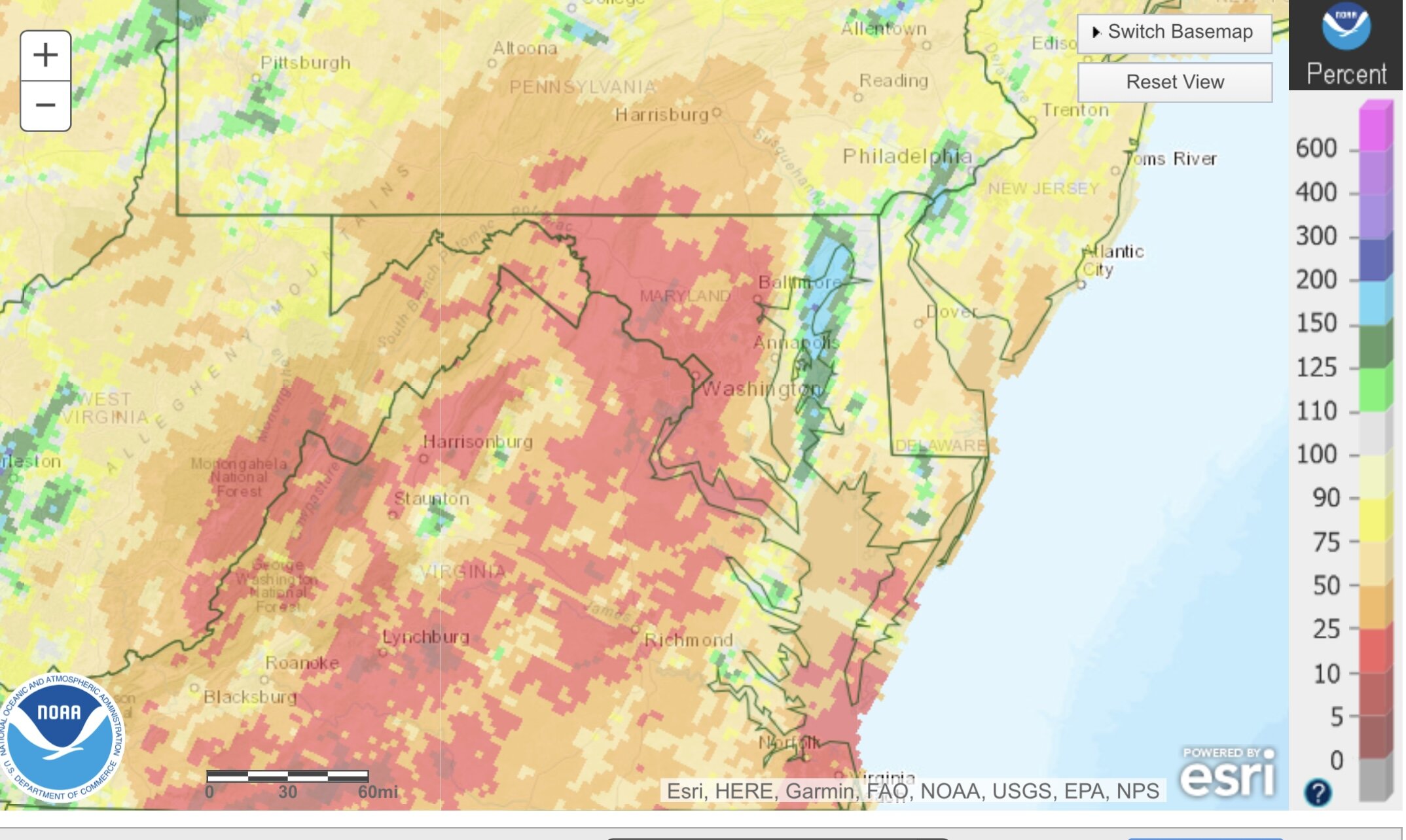
Wouldn’t mind a soak this week. Last 30 days percentage of normal precip.

-
They are building a 16 house subdivision around the corner from me, so I mostly hear beeping trucks. But hey, if you want to drop $1.7M+ on a house you can be my neighbor and you won't even have to buy a weather station!