MN Transplant
-
Posts
17,858 -
Joined
-
Last visited
Content Type
Profiles
Blogs
Forums
American Weather
Media Demo
Store
Gallery
Everything posted by MN Transplant
-
Sounds like flooding is bad in the eastern neighborhoods of Laplace. People posting on FB/Twitter for rescues. I checked some of the addresses and they are all in the same area just south of 10.
-
Hoping all is well here. In the eyewall just outside Laplace.

-
One thing on the rainfall is that even when Ida moves north overnight, somebody is going to be stuck with the feeder bands training over them.
-
Did we lose the anemometer at MSY?
-
2021 Atlantic Hurricane Season Tracking Thread
MN Transplant replied to WxWatcher007's topic in Mid Atlantic
Raining on @EastCoast NPZand not on @PrinceFrederickWx. Nah.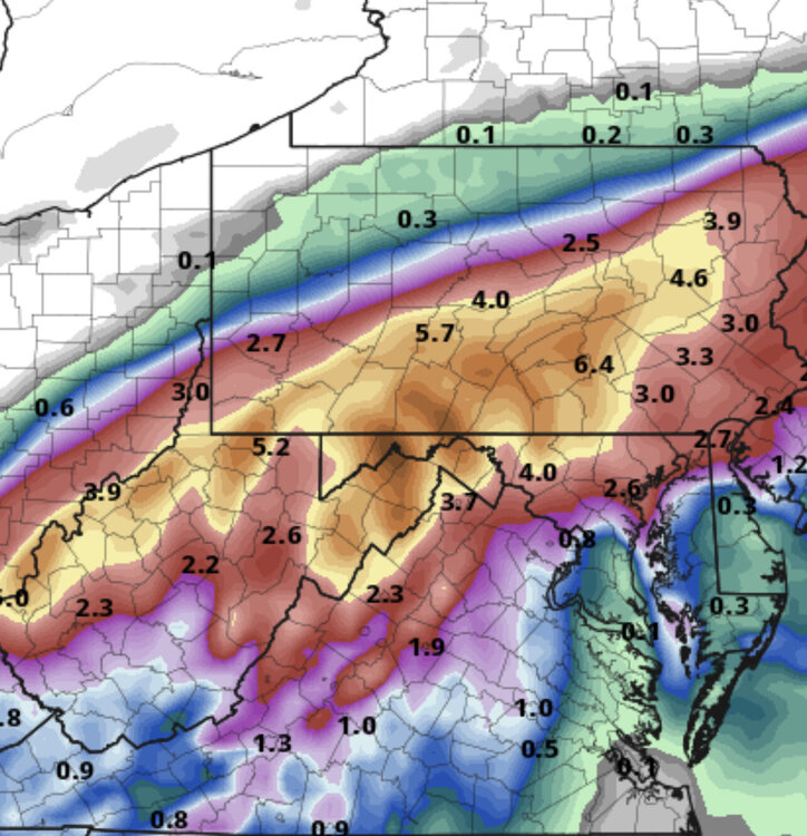
-
2021 Atlantic Hurricane Season Tracking Thread
MN Transplant replied to WxWatcher007's topic in Mid Atlantic
Euro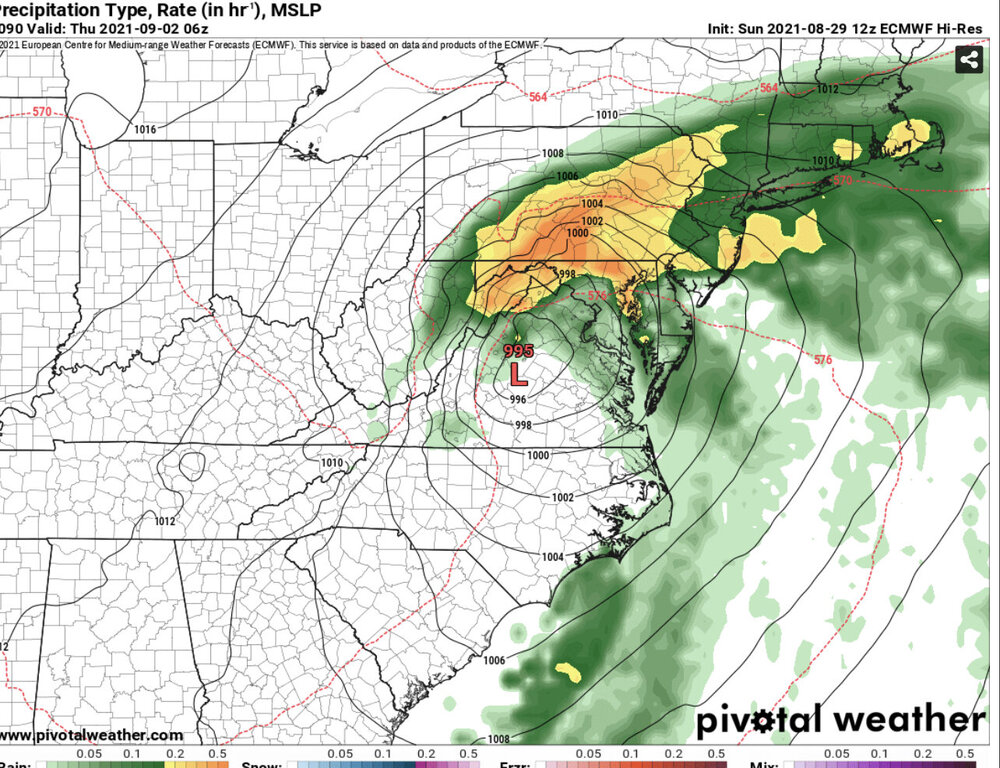
-
2021 Atlantic Hurricane Season Tracking Thread
MN Transplant replied to WxWatcher007's topic in Mid Atlantic
The Grand Isle camera is back and the house appears to be minus a porch. -
2021 Atlantic Hurricane Season Tracking Thread
MN Transplant replied to WxWatcher007's topic in Mid Atlantic
With apologies to Josh, this might be the most compelling hurricane footage I've ever seen. -
2021 Atlantic Hurricane Season Tracking Thread
MN Transplant replied to WxWatcher007's topic in Mid Atlantic
Looks like a washing machine right now. -
2021 Atlantic Hurricane Season Tracking Thread
MN Transplant replied to WxWatcher007's topic in Mid Atlantic
Excellent craftsmanship on the house in the background! -
2021 Atlantic Hurricane Season Tracking Thread
MN Transplant replied to WxWatcher007's topic in Mid Atlantic
Watching the tops of the waves flying past by the camera is insane. -
2021 Atlantic Hurricane Season Tracking Thread
MN Transplant replied to WxWatcher007's topic in Mid Atlantic
I just commented in the Tropical thread that there is trash floating by now. I'm amazed that the feed is staying up. -
Some trash floating by on the severestudios feed from Grand Isle. Could identify a cooler.
-
2021 Atlantic Hurricane Season Tracking Thread
MN Transplant replied to WxWatcher007's topic in Mid Atlantic
The lightning in the eyewall right up to landfall is amazing. -
2021 Atlantic Hurricane Season Tracking Thread
MN Transplant replied to WxWatcher007's topic in Mid Atlantic
I know that we all know not to use the 3km NAM for tropical, but here’s why -
Oh yeah.
-
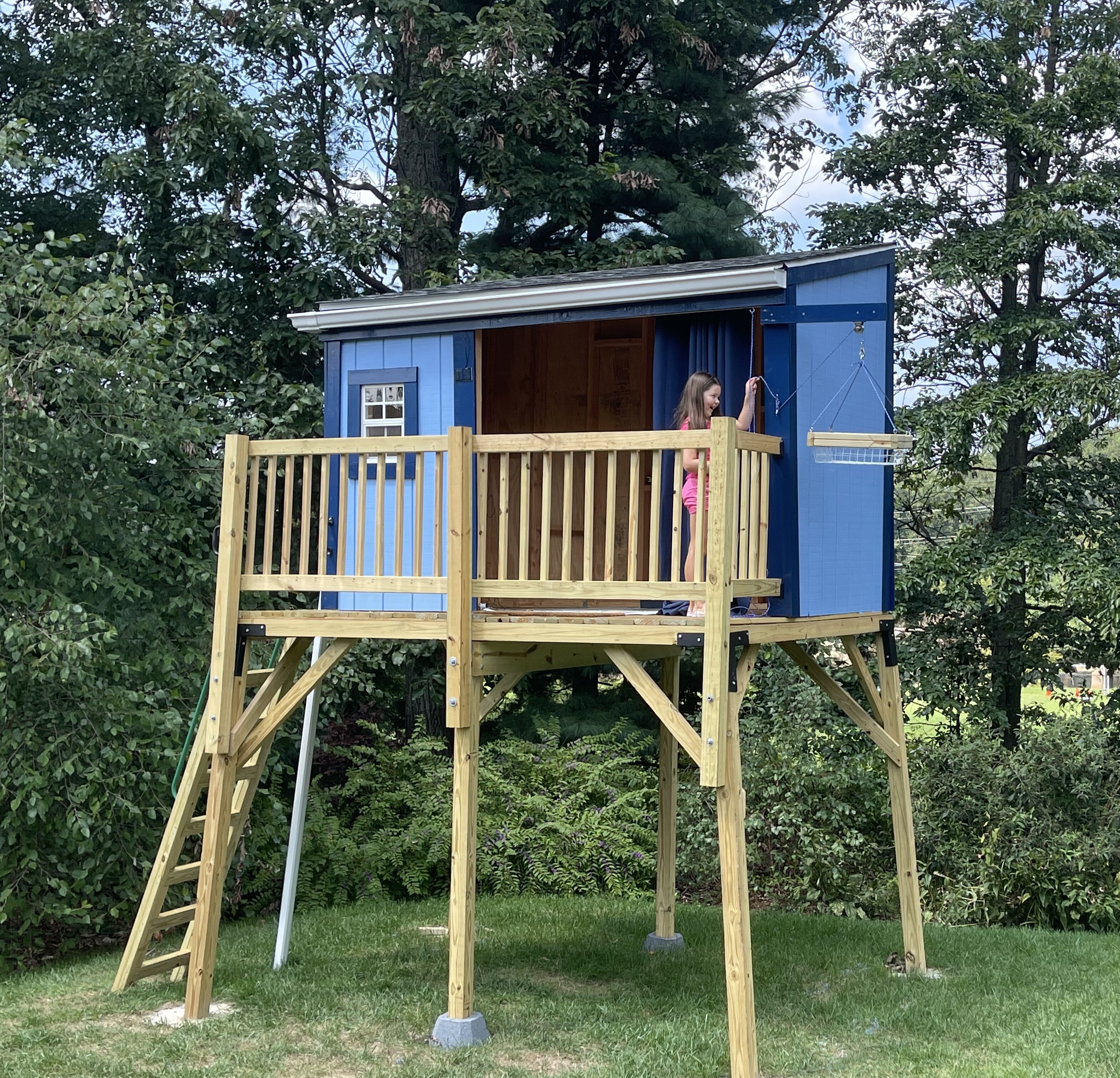
Thanks! She wanted a tree fort, but we had cut down all the good trees. So, I started with the idea of a deer stand and then it got more elaborate.
-
My magnum opus. All by hand. A couple of months and so, so many trips to Home Depot.

-
2021 Atlantic Hurricane Season Tracking Thread
MN Transplant replied to WxWatcher007's topic in Mid Atlantic
There is a national refuge between Lafayette and Baton Rouge. If the right eyewall can thread that needle, it’ll really keep the damage down. -
Nice light show to the south.
-
About 0.5”. These are moving more quickly than some in recent weeks. No wind here.
-
If that line extends SW somebody is going to get trained on a bit. Probably Annandale, because they get hit a lot.
-
First STW of the day goes to MoCo.
-
It has definitely had too little coverage over the past month of storms.
-
2021 Atlantic Hurricane Season Tracking Thread
MN Transplant replied to WxWatcher007's topic in Mid Atlantic
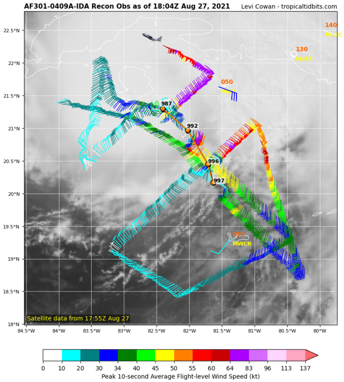
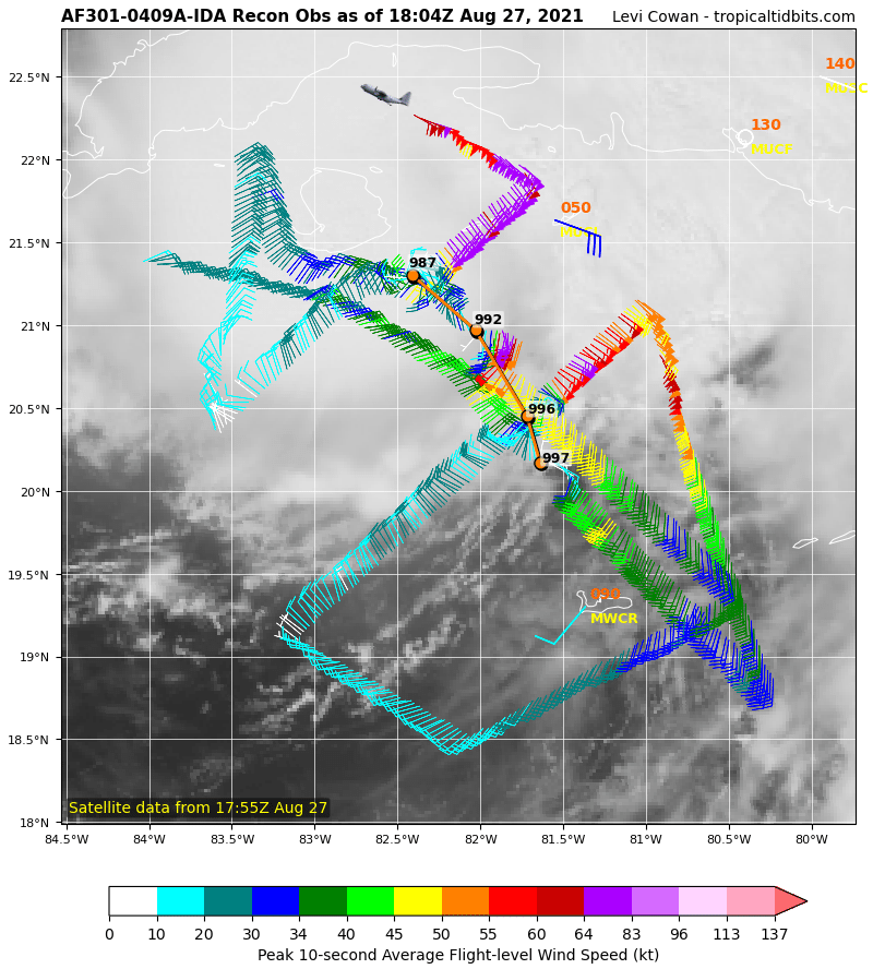
From 997mb to 987mb during the AF flight. Definite bend to the NW.