NorthHillsWx
-
Posts
5,531 -
Joined
-
Last visited
Content Type
Profiles
Blogs
Forums
American Weather
Media Demo
Store
Gallery
Everything posted by NorthHillsWx
-
ICON is a weenie run for a serious storm just pounding the SE NC coast for days
-
This thing has major 2005 Hurricane Ophelia vibes off the east coast
-
This ^^^
-
Happy hour GFS would nuke this board for days with the Gulf Stream stall then hesitant crawl towards NC
-
GFS with a hurricane landfall on both the gulf and Atlantic coasts of Florida
-

2024 Atlantic Hurricane Season
NorthHillsWx replied to Stormchaserchuck1's topic in Tropical Headquarters
I wouldn’t discount the rotting front off NC for some short lived development over the next 48 hours. -
2.56” today, all but about a half an inch fell in a 45 minute period. Significant flooding all over Raleigh when that band came through
-
It’s been down since late yesterday. It’s dumping. Edit: we have received 1.10” or rain in the last 20 minutes. This is one of the most extreme downpours I’ve seen. 9” in rear view mirror working on 10” for the month
-
Pushing 9” here mtd
-
It’s funny, we were much better at getting rain before they issued a flood watch! Just to 0.18” overnight with light rain falling this morning
-
Getting 7” of rain in a month is a good month. Getting over 7” of rain MORE than the previous month is absurd. Add my April + May + June totals and this month exceeds the sum. Incredible turnaround
-
I gave up too early 7” in rear view mirror, pushing 8” on the month. 0.67” and raining steady with more to come. Back to bed 0.84” was our total overnight
-
We missed all the storms today just right between them. 0.03” total, but keeps our rain streak alive
-
After todays rainfall our monthly total is now at 6.82”
-
Afternoon dumpage here
-
Pushing 6” on the month after heavy storms last night with light rain continuing this morning. With high rain chances continuing through the week, 10” may be in play if we get the right storms. Unbelievable turnaround
-
Sounds like most everyone has gotten into the good stuff at least once this month. At over 5” after picking up just 0.46” last month my yard has gone from not having needed mowing since mid May to mowed twice this week. Better yet, the farm in Franklin county has exceeded 8” this month and the corn, soybeans, and food plots look like we will have made it through the drought with minimal loss. Checked the corn today and it’s 7-8’ and growing fast
-
Finally getting our turn today. 3rd storm of the day incoming
-
0.02” today 4.23” for the month
-
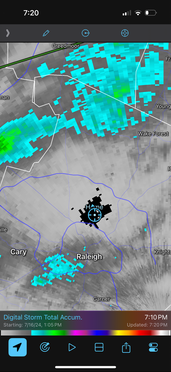
RadarScope. Best radar app you can get. We picked up 0.21” from that rotting line last night so we were not blanked. Happy for areas south and east of here where the severe drought area got drenched. Hopefully the upcoming week extinguishes the drought for the region
-
Over 2 days it’s much more drastic
-
Someone who can post pictures needs to take a screenshot of total accumulated rain for wake county right now if you want to know where my house is
-
Well, 0.10” was too much. We’re at 0.00” and got the split. Unbelievable EDIT: being in a FFW and getting barely enough rain to wet the grass is comical
-
lol that would old be pain for me. 2-4” completely surrounding my house with 0.1 right on top of me