MarkO
-
Posts
3,402 -
Joined
-
Last visited
Content Type
Profiles
Blogs
Forums
American Weather
Media Demo
Store
Gallery
Everything posted by MarkO
-
No power, looks about 6" before the flip to sleet. 33.4F
-
Overproducer. About 4" 31.6F
-
 Looks like 2" or so in Lowell per webcam. 1,5" in Thornton.
 -
1/9-1/10 Now Morphing to Less-Than-Exciting Power Cutter
MarkO replied to Torch Tiger's topic in New England
It flipped back to snow at Waterville. It also looks like the cabin only got between 1/2 and 3/4" rain, so a net gainer. Nice base builder. -
1/9-1/10 Now Morphing to Less-Than-Exciting Power Cutter
MarkO replied to Torch Tiger's topic in New England
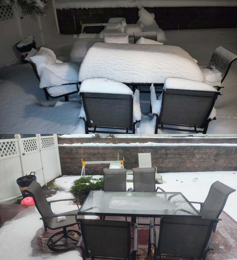
After 2.7" rain. Pack nearly decimated in Lowell. Temp hit low 50's this AM, but starting to drop now (48.6F). I'd like to know how we did up north. One neighbor said 10" before the flip to rain. about 12 hours between these two images.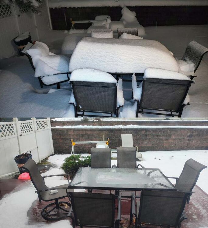
-
1/9-1/10 Now Morphing to Less-Than-Exciting Power Cutter
MarkO replied to Torch Tiger's topic in New England
1" of snow before being washed away with the pack. Down to about 4-6" on the ground in Lowell. 50.2F -
1/9-1/10 Now Morphing to Less-Than-Exciting Power Cutter
MarkO replied to Torch Tiger's topic in New England
Flipped to sleet about 5 minutes ago. Fun while it lasted. -
1/9-1/10 Now Morphing to Less-Than-Exciting Power Cutter
MarkO replied to Torch Tiger's topic in New England
Man I wish I was retired. I just got back last night. I have a public hearing tomorrow in Dracut. Grrr. Back to dendrites from huge aggregates. Closing in on a quick inch. -
1/9-1/10 Now Morphing to Less-Than-Exciting Power Cutter
MarkO replied to Torch Tiger's topic in New England
It breaks my heart b/c it is absolutely dumping. Temp went from 31.1 to 32.9 back down to 32.4 -
1/9-1/10 Now Morphing to Less-Than-Exciting Power Cutter
MarkO replied to Torch Tiger's topic in New England
Holy shit, take cover -
1/9-1/10 Now Morphing to Less-Than-Exciting Power Cutter
MarkO replied to Torch Tiger's topic in New England
Exact same here in Lowell 31.1/29.3 spitting flakes -
Weenie flakes in Thornton. It'll be many hours before the main event. 23.8/19
-
I can't remember the last time NWS was so bullish on totals 12-18" for Lowell, 5-9" for cabin. I was thinking about 2/3 those totals.
-
I've had it since last Thursday. Yesterday seemed to be the worst. Still annoying, it'd moved from my sinuses to the lungs. Is this the RSV people are talking about? Worse than the two episodes with Covid for me.
-
Ahh crap, why did they have to mention Jay Peak? I might have to make alternate plans.
-
I'll be at Jay Peak snow or shine.
-
Kinda resembles my brain activity for today. Active, yet perspective given the scale.
-
That's what my SIL's yard looks like in Portsmouth, RI where I was for Christmas. Her lawn is still growing. I actually enjoyed a cocktail in the sun in the upper 50's. It looked and felt like an early April Easter. That, combined with the recent deluge up north got me thinking how this winter has been a total freaking disaster, especially with nothing to track on the horizon. Sunsets are later, days are getting longer. The freaking ground up at my cabin is not only bare, but not even frozen. Sorry, had to get it out before I took it out on my dog.
-
Sunday, December 17 - Monday, December 18, 2023 Storm
MarkO replied to weatherwiz's topic in New England
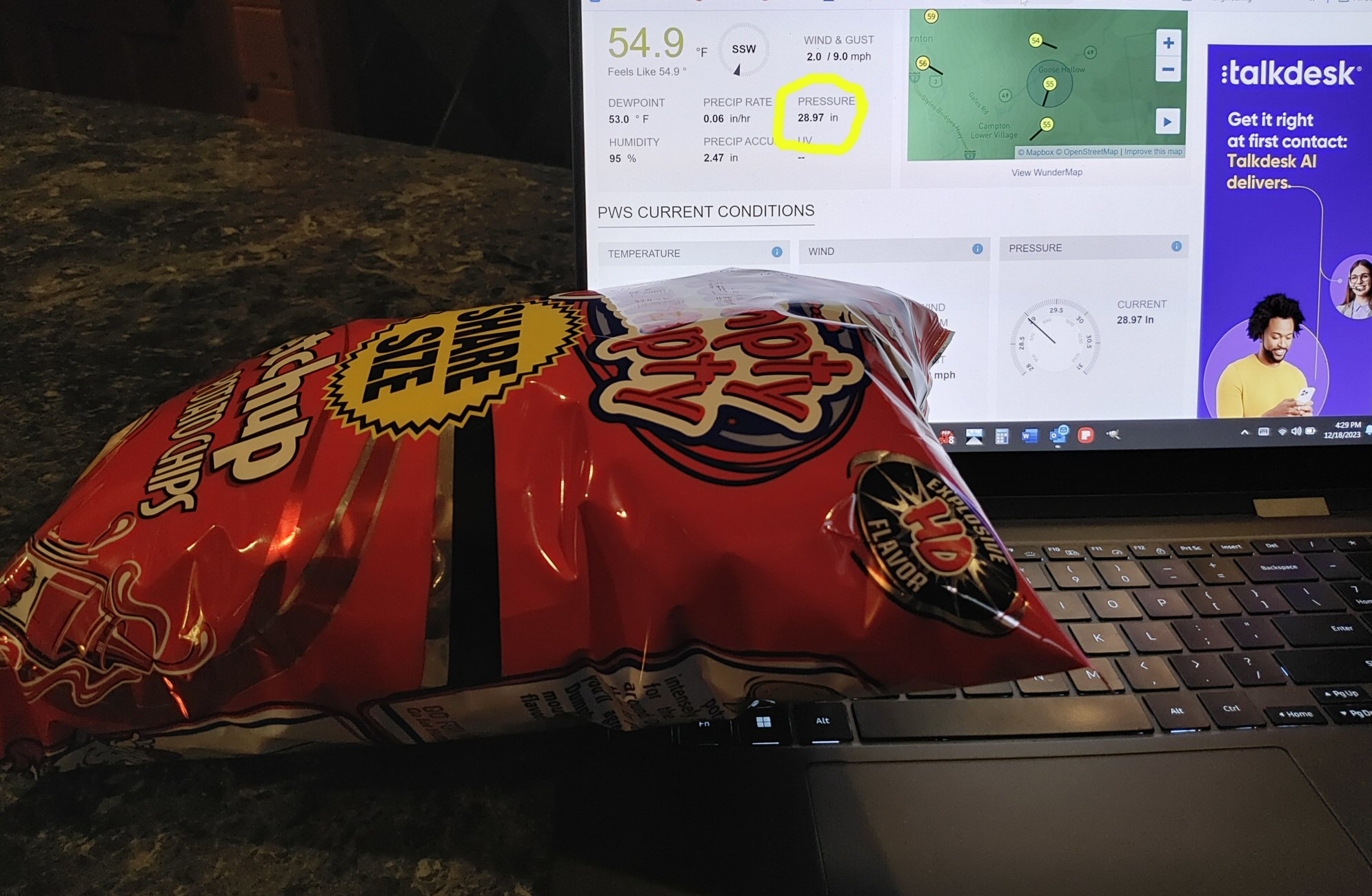
Feel like I'm out west with these chips. The bag is as firm as my 28.97
-
Sunday, December 17 - Monday, December 18, 2023 Storm
MarkO replied to weatherwiz's topic in New England
Waterville issued a "save the snow" day being closed today. They probably couldn't open the lifts anyway due to wind. I wouldn't be surprised if other mountains are closed today as well. They should be able to fire up the guns tomorrow night and nearly run them continuous through the rest of the week. Not like I can ski much anyway. I got the Ikon and Waterville Value pass and I think they're both invalid starting Saturday through the end of the year. -
Sunday, December 17 - Monday, December 18, 2023 Storm
MarkO replied to weatherwiz's topic in New England
WMUR lead off with video from the dam down the end of my street. Somewhat surprised as I've only recorded 2.6" in the bucket. https://www.wmur.com/article/campton-new-hampshire-flooding-dam/46165067# -
I believe it. Was at Santa's Village last night. Huge aggregates and the lights made for a festive evening. There was about 2" on the ground when we left around 6 or so. Back here in Thornton there was about 1/2" on the ground, but temp was 33.4, so it wasn't really accumulating. Got 3" since then, but Waterville is reporting 7" at base and 8" up top. Heading out now.
-
Heading up north for the weekend. The plan is to take the kids (nieces and nephews) to Santa's Village Sunday afternoon, and leave Monday. But it's looking like there's potential for 6" ovenight Sunday, so maybe a few runs in the AM.
-
I agree. It used to drive me nuts Waterville didn't do it as well, but they now have live cams at the top and at the base, so it's nice to see what's happening with weather, snow making, if the lifts are running, whether it's too crowded. Crowded lines rarely happened in the past, but not sure if it's Waterville's recent improvements, or the ski industry as a whole, but I've been seeing some pretty busy Saturdays, and some times I just hold off.
-
It was nice to get back out onto the mountain on Sunday at WV. The conditions were surprisingly good. Only one icy section of one trail (I should have gotten a quick tune). If you count the few turns I got in at MWN in October, I've skied every month so far this year, woohoo.