

MarkO
-
Posts
3,401 -
Joined
-
Last visited
Content Type
Profiles
Blogs
Forums
American Weather
Media Demo
Store
Gallery
Everything posted by MarkO
-
Just started as snow here as well. 36.4/30
-
I stuck around for this one. We'll find out soon. It does look juicy. I'm not expecting much. I think you'll do better than me. Maybe a sloppy inch or two here, but I'm really thinking the goods will be above about 2500'.
-
I thought this was a weather forum, but I'll take the bait. If my brother was missing for over a month and I suspected he might be in a well, I'd prolly check it myself. I can only imagine the stench. Also something weird about the brother. At a minimum he seems to be $#itfaced in the interview. Something more to that story. 35.4/24.0, might start as snow, we'll see.
-
The Wildcat webcams show it still dumping. I think today is their opening day.
-
Looks like it flipped to rain at cabin. Hard to tell how much from webcam, but maybe 5 or 6". We actually dropped down to 33.8F in Lowell and there was about 1/4" accumulation on cars, grass, but that obviously melted by this AM.
-
It flipped over to mainly snow, but I've probably bottomed out at 34.9ZF
-
37.8/32.6 If I squint hard enough, I can see cat paws on the car windshields.
-
Snowing nicely up north 29.6/26.0, but just rain here in Lowell 38.5/31.5.
-
First flakes at cabin, but up to 38.7 in Lowell. Gonna have to count on evaporational cooling here. Not sure why I left there this morning. All I had was a stupid zoom meeting.
-
At 35/28, wouldn't you expect to start as snow, or at least sleet? I'm at 36.3/26.0 and expect to see a couple mangled flakes even though it looks like some southeast flow at lower elevations (I'm guessing) on radar. 31.3/21.0 up north. Hoping we can squeeze out half a foot up there.
-
Did WKevin ever start up snow totals for this season?
-
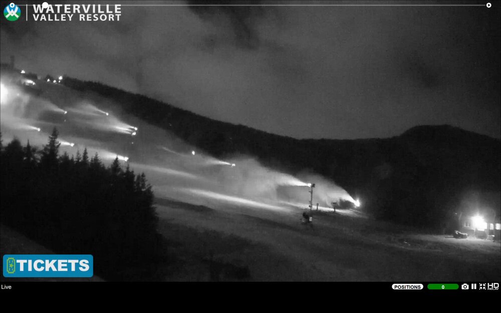
I was surprised to see Waterville keep them running all night. Even now in what I assume are marginal conditions. There looks to be a warm layer around 3500-4000' Looks like we picked up about an inch. Still below 30F @ 1100'
-
Pingers in Lowell. 35.6/24.3
-
It seems like a lot of the larger resorts are cranking up the guns. Killington and WV started Monday night. I know Bretton Woods and Cannon were blowing snow yesterday. Last night Sunday River started snowmaking on Jordan Bowl. It's been snowing at Killington, but not sure if that's a good thing. I think the higher dews doesn't help, but temps are still in the mid 20's. I'm sure they'll be open by Friday, but does someone else open tomorrow afternoon to take the title to be the first to open? I'm not including that pile of snow Ward created.
-
I wish! I just don't ever see that happening since it's run by the State.
-
Considering it takes concrete 28 days to cure, probably not this winter. Speaking of which, I expected to see Killington and Sunday River firing up the guns (which I assume they have), but not WV. I've always wondered why they didn't pound snow early on High Country. Maybe with the new snow making system and new 6 pack chair, and new surface lift to the top it was part of their plan. Way to go WV!
-
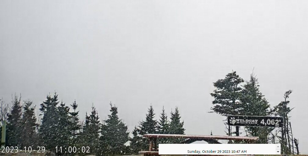
I noticed sleet on the WV webcam, but snowing at the top of Wildcat.

-
Not sure about Wildcat, but I'd wager Killington will, maybe even Sunday River.
-
I believe they've made snow as early as late September, but earliest opening is October 1st. I skied there once on October 4th in 1997, I think That was my earliest skiing ever (I guess if you don't include skiing indoors). I had skied Tucks earlier that summer on July 4th when MWN got 96" in May alone. We planned skiing it Memorial Day weekend, but avalanche warnings were either high or extreme, so we postponed. That was in the infancy of the internet, but we figured there's be enough snow to ski the bowl, but on our way north the toll operator laughed at us when she saw the skis on the roof saying there's no snow in NH in July. When we got to Pinkham Notch, the higher elevations we clouded over, so we still weren't sure, but there were other diehards strapping skis to their frame packs, so we felt at least a little less embarrassed. I believe some made a couple turns into August that summer. Here's a list of earliest openings. I sure hope they can pull off an October opening this year, or I'm going to be spending money on a flight to Denver. https://www.killington.com/plan-your-trip/getting-here/operating-schedule/historical-open-close
-
It's a little colder than you might expect. Unlike an ice rink, they keep the entire ski area at about 25F. No wind, but it's humid. The snow has got a weird loose consistency, but as I mentioned, you need the right wax, and the wax they use is 100% the WRONG wax! I'm not sure if they do it that way to keep speeds down, but it was very annoying to have to push to get to the bottom. It's a terrible experience, and I feel for people trying to learn for the first time.
-
Got in September, but with an asterisk. Terrible drive down and back on Friday. Record daily rainfall, and I took the vette which is terrible in rain. Worst mistake was renting skis. They were junk and used the wrong wax. Just a terrible experience overall.
.thumb.jpg.b4eac6d13715c568c935f278bf3a1f90.jpg)
-
 Any thoughts on fetch and Bay of Fundy?
 -
Stick a fork in her. Boy it got quiet here. Has been a TOR otg past 1/2 hour and not even a mention about it.
-
Fixed it for ya.
-
It's all going to come down to Lee's forward speed.


.jpg.5a4542f3923cee8084b3da49b3c84898.jpg)

