MarkO
-
Posts
3,401 -
Joined
-
Last visited
Content Type
Profiles
Blogs
Forums
American Weather
Media Demo
Store
Gallery
Everything posted by MarkO
-

Genug Shoyn Mit warm and brown! Is Jan 19-20 a storm to shift the vibe?
MarkO replied to mahk_webstah's topic in New England
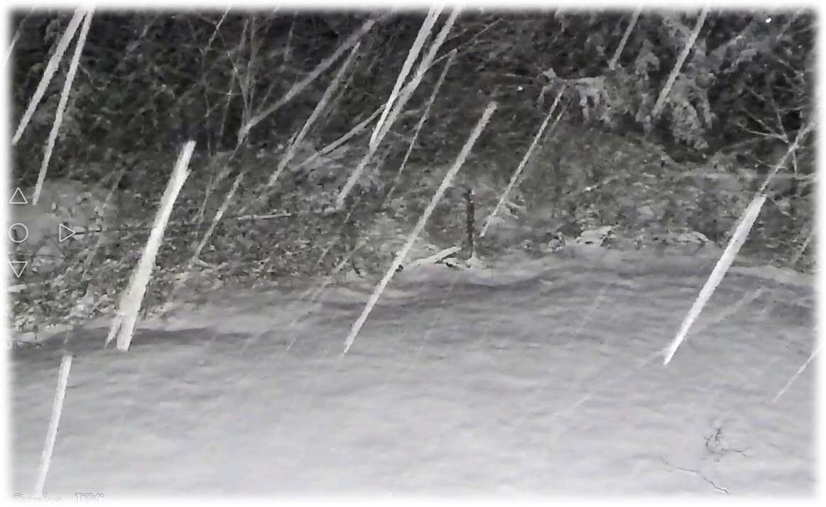
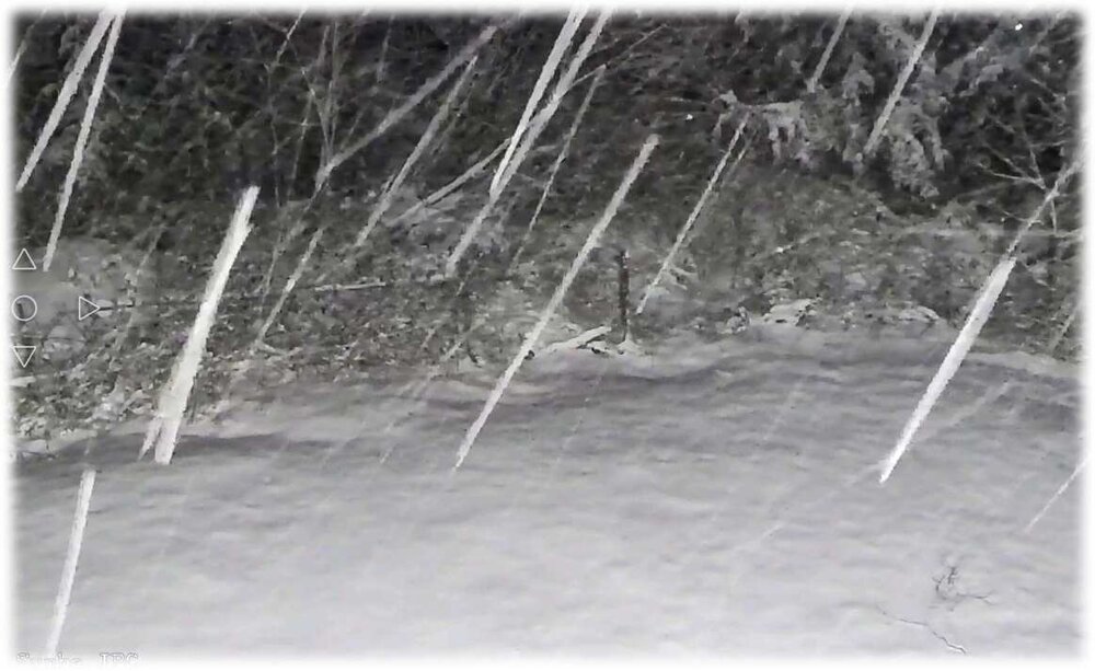
Webcam shows about 3-4" in Thornton -
Genug Shoyn Mit warm and brown! Is Jan 19-20 a storm to shift the vibe?
MarkO replied to mahk_webstah's topic in New England
The larger (~6" dia) took out the neighbors mailbox.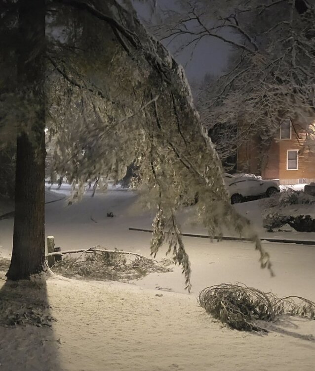
-
Genug Shoyn Mit warm and brown! Is Jan 19-20 a storm to shift the vibe?
MarkO replied to mahk_webstah's topic in New England
3.6" in Lowell 32,2F. Couple white pine branches down. -
Genug Shoyn Mit warm and brown! Is Jan 19-20 a storm to shift the vibe?
MarkO replied to mahk_webstah's topic in New England
Knew it was only a matter of time. Huge pine branch just dropped in neighbors yard. The lower branches on the large white pine in my front yard are nearly touching the ground. Usually they're about 10-12' off the ground. -
Genug Shoyn Mit warm and brown! Is Jan 19-20 a storm to shift the vibe?
MarkO replied to mahk_webstah's topic in New England
This moderate snow of big fatties is piling up. 2.75" at 1 AM. 32.0F -
Genug Shoyn Mit warm and brown! Is Jan 19-20 a storm to shift the vibe?
MarkO replied to mahk_webstah's topic in New England
Nice pasting on everything. Heaviest snow so far. Temp holding at 32.2F -
Genug Shoyn Mit warm and brown! Is Jan 19-20 a storm to shift the vibe?
MarkO replied to mahk_webstah's topic in New England
Flipped back to sleet here as well. Let's see what's under these incoming heavier returns. -
Genug Shoyn Mit warm and brown! Is Jan 19-20 a storm to shift the vibe?
MarkO replied to mahk_webstah's topic in New England
1...0, bingo. just flipped here in Lowell. Don't get me wrong, it's still a very wet snow. -
Genug Shoyn Mit warm and brown! Is Jan 19-20 a storm to shift the vibe?
MarkO replied to mahk_webstah's topic in New England
Same here. -
Genug Shoyn Mit warm and brown! Is Jan 19-20 a storm to shift the vibe?
MarkO replied to mahk_webstah's topic in New England
Going back and forth between sleet and snow. Gradually cooling. 34.2/31.0 -
Genug Shoyn Mit warm and brown! Is Jan 19-20 a storm to shift the vibe?
MarkO replied to mahk_webstah's topic in New England
Just took another look and it's sleet and and a few mangled flakes. 36.1/30.1. Going to need some better lift/intensity. -
Genug Shoyn Mit warm and brown! Is Jan 19-20 a storm to shift the vibe?
MarkO replied to mahk_webstah's topic in New England
Not happening in Lowell. Drizzle, 37.6/29.4 Edit, went outside to check, sleet here as well. -
Genug Shoyn Mit warm and brown! Is Jan 19-20 a storm to shift the vibe?
MarkO replied to mahk_webstah's topic in New England
LOL, my wife's family is on the other side of the Mt. Hope bridge (Portsmouth). There are many a times (this just another typical example), where I tell them "snow at the cabin, maybe a few inches here in Lowell, but rain in Rain Island". I'm heading north, they'e heading south. My daughter hates snow. Maybe part of the reason she's at URI. They do very well with Benchmark storms. Lots of wind too. -
Eyeballing about 2.5" in Lowell
-
55.0 Lowell, 32.6 Thornton. Despite the rain after midnight, still looking very wintry,
-
Looks like it flipped to sleet in Thornton.
-
still snowing at cabin
-
About an inch in Lowell, but flipped to rain. Looks like a couple inches already up north. I'm feeling like this one could be an overproducer (NWS forecasting 4-6"). Regardless, it should be a net gainer. Start rebuilding the pack!
-
Been hovering at 32.4F pretty much all day. Looks like an inch or so on non-paved surfaces, but it did accumulate on the asphalt too, but less than an inch. Just enough for me to get out there and shovel it off. Looks like more at the cabin. I'm eyeballing about 2 inches, maybe a little more. Temp up there hovered around 31 throughout the day.
-
I think it may have been. There was a delay of at least a few seconds. About 200k without power in MA. Still pretty gusty, so don't expect power for at least a few hours.
-
Quick burst of precip and wind as the front passed through. One flash of lightning, big gust and sound of a transformer blowing. No power in Lowell.
-
I'm wondering how conditions will be moving forward? It looks like the larger mountains got between 2 and 5 inches before the flip, ending up with more or less a neutral event, but I'm wondering (maybe Scott can answer best), if this rain can somehow drain, the groomers maybe sit on it (most ski areas closed today) and maybe an inch refresher, will it be bullet proof, or end up with more of just a firm base, but hold an edge kind of conditions?
-
if/when they iron out the kinks with that lift, you'll rarely see that lift being more than a 2 minute wait. Doing some quick math, 10k'/hr may be doable, not that you'd ever see me doing that. It does look like the mountains may end up with a net zero after Friday's event. Euro suggests it may even be a gainer. Just not sure how much damage 2" of a 40F rain will do.
-
Saturday was excellent at Waterville. 2+ feet of moderately dense snow. Loon was fantastic today. Take advantage of the great conditions because come Satuday expect surfaces to become bullet proof.
-
Preliminarily ... a medium impact partial Miller B, Friday
MarkO replied to Typhoon Tip's topic in New England
Just got up north. I93 was pretty bad between exits 22 and 25. About 3" OTG, maybe a little more.