

crossbowftw3
-
Posts
1,394 -
Joined
-
Last visited
Content Type
Profiles
Blogs
Forums
American Weather
Media Demo
Store
Gallery
Everything posted by crossbowftw3
-
Wednesday, April 21, 2021 Low Topped Squall Line
crossbowftw3 replied to weatherwiz's topic in New England
hearing some rumbles here in the Catskills, should be interesting for you guys once this thing really gets rolling. -
Few Tstms with hail-gust 40-45KT 1P-6P especially NJ/se NYS/w LI
crossbowftw3 replied to wdrag's topic in New York City Metro
First signs of development happening nearby here in the Catskills. Just rain here with a rumble of thunder -
Wednesday, April 21, 2021 Low Topped Squall Line
crossbowftw3 replied to weatherwiz's topic in New England
if the upcoming large scale pattern is to be believed you may see that happen in KS/OK....on the 10th anniversary of 4/27/11 no less -
Few Tstms with hail-gust 40-45KT 1P-6P especially NJ/se NYS/w LI
crossbowftw3 replied to wdrag's topic in New York City Metro
Good chance that the storms begin to intensify right over top of me in about two hours’ time. Greatest threat is much more confined to my East but I could see a good storm here anyway. -
Wednesday, April 21, 2021 Low Topped Squall Line
crossbowftw3 replied to weatherwiz's topic in New England
Perfectly timed too as it looks like the grander pattern implies severe weather season across the eastern 2/3rds of America looks primed to really kick off starting this weekend. -
Few Tstms with hail-gust 40-45KT 1P-6P especially NJ/se NYS/w LI
crossbowftw3 replied to wdrag's topic in New York City Metro
Pretty reasonable parameters will be in place for at least some reports of severe tomorrow but probably nothing too widespread. Temps crash then thereafter too....those of us who are inland might see our last flakes (for sure this time) for at least the next six months with permanent warmth looking like its only a week out at this point. -
Considering this was buy and large the storm of the season (and biggest accumulations for NYC since ~2016/those of us N&W folks since Pi Day) for most of this forum that’s kind of a disgrace
-
Were you able to see anything last night? Got nothing here in Narrowsburg.
-
temperatures have only come down two degrees since this post here, 44 in Narrowsburg. Whether flakes happen tonight remains unclear. From what I've seen in the NE forum temperatures are beginning to fall rapidly there and the highest elevations are already changing over
-
temps here did crash from 56 to 46 from 1-3 PM but have remained steady in the hour since. we'll see what happens, I'll go with 1-2 or so for your house tonight into tomorrow with car topper for me
-
you'll get your blown transformers
-
But for nothing more than 2-3" at most. That'll be a win if it can happen
-
you still have a shot for something at your place in Liberty, I am discounting anything more than car topping at 800' here. Gonna be fun to watch what happens in CT/MA tonight
-
rain finally beginning for real here outside of a random sprinkle about 90 minutes ago
-
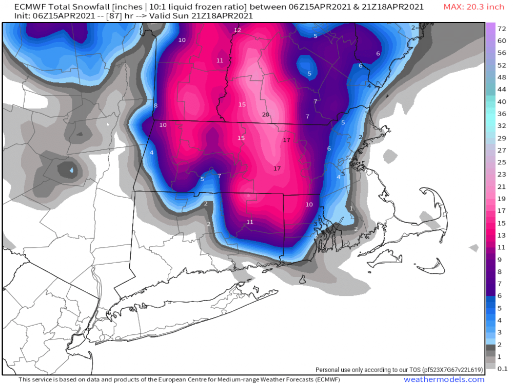
Ginx came through with the snow map. Crusher
-
Here in the Western Catskills we may not even see .25” of rain now. This could be a special one for you guys. Gonna root for you guys. Enjoy it
-
Gonna be a special one for those guys. Rooting for them (until they inevitably lose power from the weight of the snow)
-
Snow Map? Just for morbid curiosity since I know those of us in this subforum and its n/w suburbs miss out on this one
-
Turned into a pretty pathetic rain event as well for most of us. May struggle to even see .25” here.
-
It will be close...I would like to see something. I’ll be watching as many streams as I can find from areas in the Berkshires tomorrow evening.
-
18z NAM keeping up the same story. All of us here look to probably end up dryslotting for at least half of the night tomorrow.
-
It now looks quite likely those of us in the western Catskills stop the precip for a time tomorrow night
-
how many more ticks until we get Kevin doing naked snow angels while branches snap all around? asking for a friend.
-
SImply put, everything failing to come together in time for everyone west of the Hudson.
-
running out of time for major shifts, so I'm discounting anything significant this far west sans at elevation; however, everyone certainly can and probably even will still see some snow

