

crossbowftw3
-
Posts
1,394 -
Joined
-
Last visited
Content Type
Profiles
Blogs
Forums
American Weather
Media Demo
Store
Gallery
Everything posted by crossbowftw3
-
Surely there will be a boom in nine months. This is just the beginning
-
And two remain (of the directly to NYC tracks)
- 1,603 replies
-
- 1
-

-
- hurricane gusts
- flooding rains
- (and 2 more)
-
Another day and time, Ant
-
Kindly prefer cloudy and slightly breezy as opposed to 3-5+” of rain
-
More this than anything. C LI to Block Island LF is growing ever more likely
-
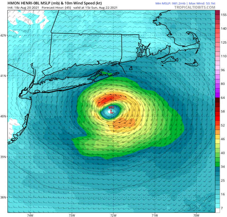
HMON back to its senses WRT other guidance with an 82kt maximum
-
82kt maximum

-
I believe the cause was a power surge considering it was on Main Street.
-
During the May 2018 Derecho I had no power for 3 days/6 hours after the storm and being without lights for 3+ days is no fun at all. The sad irony of that was a furniture store in town where I live caught fire when 75% of town got their lights back that Friday night. It sits gutted and abandoned now, a mere block from a certain celebrity’s wife’s shop. Life is weird, and so is the weather.
-
I’m impressed. Connecticut has come a long way from the Stone Ages of...2020.
-
Better hope Eversource can mobilize 1000 trucks out of their fannies because yall are going to need it
-
Would wonder if us inland folks N/W of the city proper could see another rare summertime wind advisory like we did with Isaias.
-
Will have to refer to Louisianans for that answer.
- 1,603 replies
-
- 1
-
-
- hurricane gusts
- flooding rains
- (and 2 more)
-
Send Jim Cantore to islip.
-
Definitely growing concerned with all of that potential water. Our threat isn’t wind...but...we may as well find the boats because we could be having to row our way to the supermarket next week. Lol.
-
My concern for flooding here inland has gone up a good deal since the 12z models ran their course. Definitely have to think ALY/BGM will have just as much of a mess on their hands as OKX/BOX will watching where the heaviest rains end up.
-
No Kevin doing mud angels then. Bummer
-
Still think somewhere in the vicinity of Montauk is likeliest, I love the move NHC made this morning to have a blanket hurricane watch from LI to the Cape.
-
TS force easily
-
Notable enough that it’d break the 30-year-long wait between true hurricane LF in the northeast...but honestly the most significant impacts wind wise being confined to a much more confined space.
-
Good to hear from you again first of all. Second, Sandy comparisons cannot necessarily be entertained, but a minimal hurricane anywhere close to NYC is highly noteworthy all the same
- 1,603 replies
-
- 1
-
-
- hurricane gusts
- flooding rains
- (and 2 more)
-
Here’s why the 3k cannot be used for TCs: https://twitter.com/burgwx/status/1217839589836099586?s=21
- 1,603 replies
-
- 5
-
-
- hurricane gusts
- flooding rains
- (and 2 more)
-
Very much so. Not even on the same plausible scale of what will be reality with this storm
-
You can’t ever really use the NAM 3k for TC genesis and intensification.
-
I definitely have to be inclined to start believing the flood potential here inland if the center trends any closer to that W-C LI goalpost


