crossbowftw3
-
Posts
1,399 -
Joined
-
Last visited
Content Type
Profiles
Blogs
Forums
American Weather
Media Demo
Store
Gallery
Everything posted by crossbowftw3
-
january 3rd potential coastal grazer
crossbowftw3 replied to forkyfork's topic in New York City Metro
This one’s going to the wire, wouldn’t shock me if you guys closer to NYC (and south) cash in on this one just as long as you let us inland folks have this weekend’s potential -
We’ve seen these things before, and wouldn’t shock me if that’s the case here. Nearly 30” in South central VA through at pure 10:1 though, lol.
-
It’s like living in Groundhog Day, another rainy and foggy Christmas morning. At least there’s no wind to deal with today.
-
Actually has just been full liquid so far in Sullivan, albeit I live in probably one of the lowest elevation areas of the county (still at 700’)
-
Advisories populated now, most for 1-3” and maybe a bit of ice before most go to rain. Still all snow north of us.
-
Coming back to this hours later: daytime event only places a cap on the level of accretions. Probably only up to .2” ice at most in elevation
-
Taking typical QPF reductions into consideration, and in conjunction with how temperatures should possibly be right between 29-32 for the event, you still probably see a solid .1-.3 event. Still enough to draw some advisories or even a short fuse ice storm warning for anything more. Elevation remains key.
-
Right at 50 here at quarter past in the Catskills with little wind to speak of yet. Clearing skies are on their way to our friends in WNY—they’re gonna get whacked. I did not but certainly had downpours here.
-
Not yet interested in what models are showing for next week. Call me again in 3-4 days so I can scramble to pull out my snow cleaning equipment
-
We stopped right around 1.25-1.5” here, made for a decent first snow. More surely to come as this winter wears on.
-
Actually coming down at a solid clip in Sullivan, wouldn’t be shocked to squeeze out a couple inches
-
The rain very briefly came to an end here before it quickly picked back up again. Guess I will break 5” in a storm for the second time in seven weeks
-
OBS and nowcast 9PM tonight-8A Wednesday for a general 2-5" rain, isolated 8" possible. 40-60 kt damaging wind likely Tuesday-early Wednesday. Focus for damaging wind and heaviest rain is the I95 corridor to the coasts. Power outages esp CT LI.
crossbowftw3 replied to wdrag's topic in New York City Metro
Rain has finally subsided in Sullivan, now time to see about the second wave and how close in it can approach. -
OBS and nowcast 9PM tonight-8A Wednesday for a general 2-5" rain, isolated 8" possible. 40-60 kt damaging wind likely Tuesday-early Wednesday. Focus for damaging wind and heaviest rain is the I95 corridor to the coasts. Power outages esp CT LI.
crossbowftw3 replied to wdrag's topic in New York City Metro
It would appear the low’s stalling and retrograding back west process has commenced -
OBS and nowcast 9PM tonight-8A Wednesday for a general 2-5" rain, isolated 8" possible. 40-60 kt damaging wind likely Tuesday-early Wednesday. Focus for damaging wind and heaviest rain is the I95 corridor to the coasts. Power outages esp CT LI.
crossbowftw3 replied to wdrag's topic in New York City Metro
Dry slot never properly overtook me apparently (upslope/enhancement?), it’s still coming down albeit at a much slower clip compared to earlier. Must be closing in on 5” with about 12 hours of rain remaining. -
OBS and nowcast 9PM tonight-8A Wednesday for a general 2-5" rain, isolated 8" possible. 40-60 kt damaging wind likely Tuesday-early Wednesday. Focus for damaging wind and heaviest rain is the I95 corridor to the coasts. Power outages esp CT LI.
crossbowftw3 replied to wdrag's topic in New York City Metro
I’m far enough away from NYC that I would be considered as just being on the fringes of this subforum, if that helps. -
Upstate/Eastern New York- Meteorological Fall
crossbowftw3 replied to BuffaloWeather's topic in Upstate New York/Pennsylvania
4” of rain at my location in the Catskills, with dry slot incoming to try and shut us off precip wise. If only this storm track happened two months from now with an actual cold supply -
OBS and nowcast 9PM tonight-8A Wednesday for a general 2-5" rain, isolated 8" possible. 40-60 kt damaging wind likely Tuesday-early Wednesday. Focus for damaging wind and heaviest rain is the I95 corridor to the coasts. Power outages esp CT LI.
crossbowftw3 replied to wdrag's topic in New York City Metro
Look to be approaching 4” here and still raining at a very solid clip, but the dry slot is trying to come in and shut us off. After that our most significant rains are probably done here n/w of city proper. -
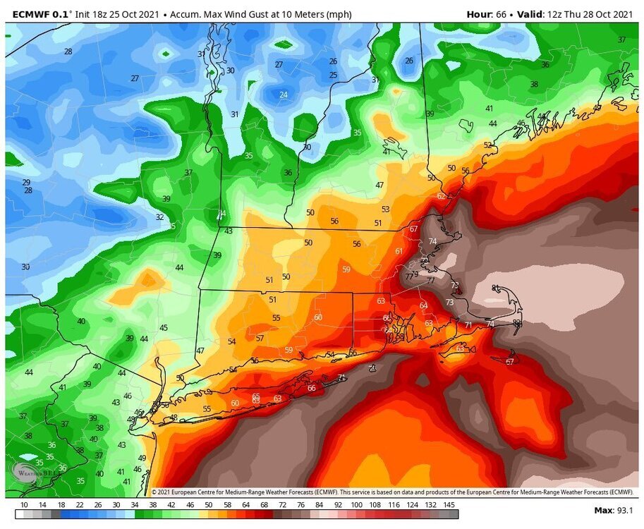
If trends hold I’ll be very surprised if Upton doesn’t issue wind advisories for the rest of LI and maybe into NYC proper
- 306 replies
-
- 1
-

-
- heavy rain
- damaging wind
- (and 1 more)
-
OBS and nowcast 9PM tonight-8A Wednesday for a general 2-5" rain, isolated 8" possible. 40-60 kt damaging wind likely Tuesday-early Wednesday. Focus for damaging wind and heaviest rain is the I95 corridor to the coasts. Power outages esp CT LI.
crossbowftw3 replied to wdrag's topic in New York City Metro
Walt: I assume wind potential for us inland folks probably won’t be too significant? I’m thinking maybe higher spots see 40+ gusts but most everywhere sees 20-40.- 228 replies
-
- 1
-
-
- heavy rain
- flash flooding
- (and 2 more)
-
I can’t imagine wind will be particularly notable for most folks inland n/w of the city. Closer to you there could be some wind later on but where I’m at I don’t expect winds to gust past 30-40
-
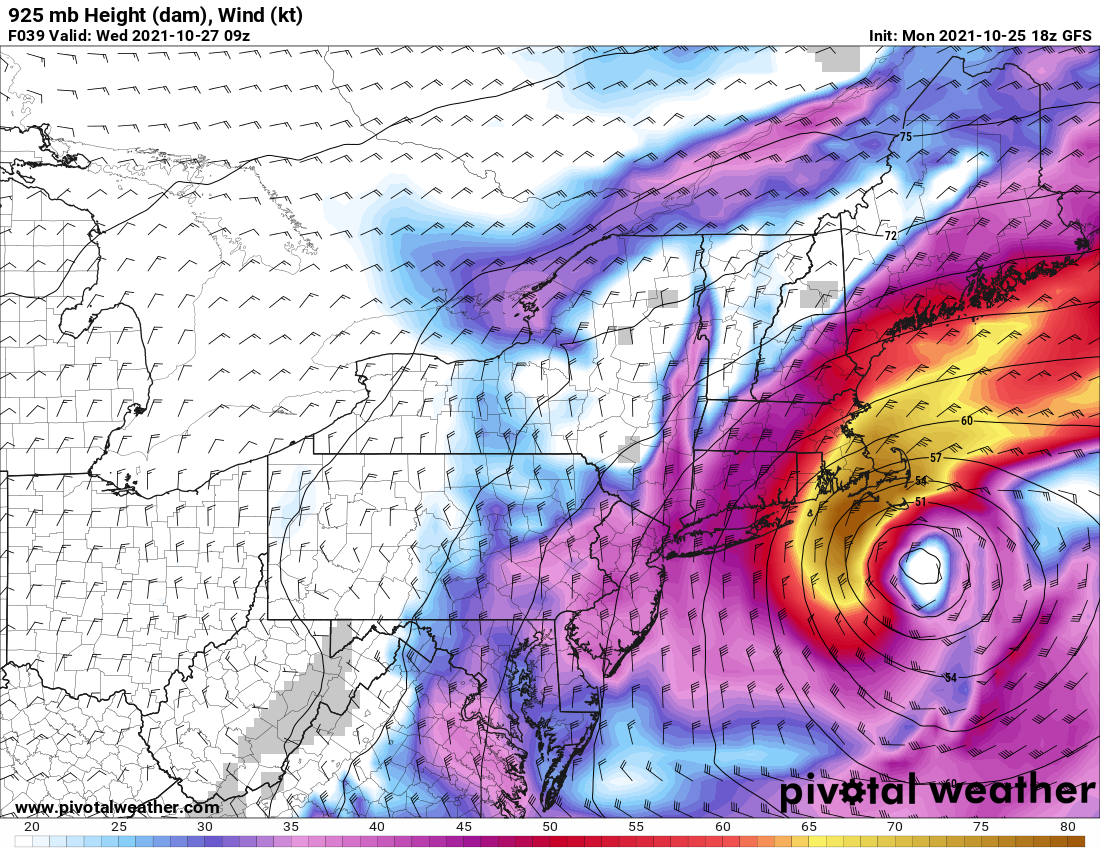
18z GFS still has some really crazy winds for ENE at 925
-
BOX already acting on high wind watches for their CWA—definitely going to be rocking on the coasts. Gusts 20-40 seem more likely the further inland one goes