

Kmlwx
-
Posts
13,215 -
Joined
-
Last visited
Content Type
Profiles
Blogs
Forums
American Weather
Media Demo
Store
Gallery
Everything posted by Kmlwx
-
15 and 21z SREF runs both placed the bullseye (nothing too high) of tor ingredients right over the DC metro tomorrow afternoon.
-
Just had a chance to sit down and look at some of the guidance. ARW, ARW2 and NMM pretty much show nothing for us tomorrow. HRDRPS has some nice looking activity in the 20z time frame...but not sure I'd want to put all my eggs in the HRDRPS. We'll probably be stuck with a game time call.
-
Looking at the 18z long range HRRR and the latest 3km NAM - I'm pretty torn. They don't really have much activity in the area - but they do hint at the possibility for one or two good cells. Seems like our usual type of event where it could be an absolute nothing-event. But that SPC and LWX discussions definitely are conditionally very intriguing. A few days ago I had this pretty much written off. Will come down to our typical question of instability. Would be a lot of fun to track something given how downtrodden a lot of folks are right now with the COVID-19 outbreak.
-
I've been on COVID monitoring for days/weeks now. This one kind of crept up on me...
-
Tambora, Toba, Long Valley, Yellowstone, St. Helens, Pinatubo all in one afternoon.
-
We are probably going to need a massive near-equator volcanic eruption to get us some good winter
-
Part of that is also what you've adapted to. 70 degrees with a dew in the upper 50s can feel awesome in fall but humid in spring.
-
Areas that have been in the clearing for the longest have warmed into the mid 60s.
-
There's a large area of clearing encroaching a big chunk of the area.
-
Line of clearing skies running between Lexington, Charlottesville and Culpeper. Another little patch of slight clearing up near HGR.
-
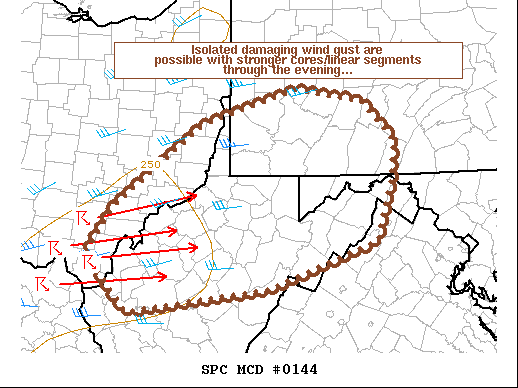
https://www.spc.noaa.gov/products/md/md0144.html
-
That is a very impressive sim radar. NAM doesn't look anything like it.
-
The parameters in some regards look better than the other day even. Simulated reflectivity on the longgggg range HRRR from the 12z run looks really nice.
-
Someone is a little cranky today eh? psu is one of the most respected posters in our subforum and even the entire forum at-large. Nobody scores a 100% in the world of weather. You seem awfully inflammatory...
- 820 replies
-
- 10
-

-

-
Payback for a TOR "outbreak" a few weeks ago lol. I'm getting bored without anything substantial to track.
-
@yoda - don't know if I'd refer to that as "gungho" seems more like they are just saying IF there was an area that had a higher risk - it would be there. The background risk is pretty low still. They just do a great job it seems of fleshing out the discussion and describing the potential.
-
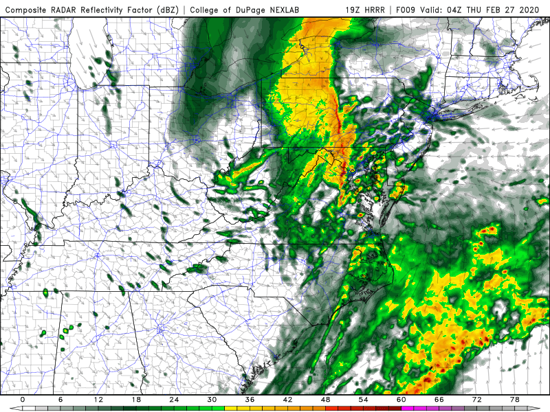
19z HRRR at 04z this evening. Looks acceptable.
-
Different timing too - though some might argue the timing was even worse for that one. Wasn't it during the morning rush? I remember I was stuck in it driving to work around 7:45 that morning. I guess timing doesn't really mean crap in these low CAPE cold season events.
-
https://www.spc.noaa.gov/products/md/md0131.html Just posted to Twitter - but it's not up on SPC quite yet.
-
That's about the max potential on this one. Absolute max. My current thinking (not very bold) is for zero TOR reports in the LWX CWA this evening and fewer than 5 reports of wind damage. I'm sure LWX will throw up a few warnings. I'll go max measured gust of 53mph.
-
The latest HRRR looks a bit better. Nothing significant but just a more solid line and a bit more on the gusty wind side of things. The weenie in me also sees a tiny bit of that light green shade on the UH maps.
-
16z HRRR had a bit more of a consolidated line.
-
Then again - it's the HRRR and could be totally wrong - but with agreement maybe not.
-
HRRR continues to send the most continuous part of the line mostly to the north of Central Maryland. It's more broken in DC proper and very scattered south.
-
Awesome visible satellite this morning https://i.imgur.com/yJLUNWt.mp4

