

Kmlwx
-
Posts
13,592 -
Joined
-
Last visited
Content Type
Profiles
Blogs
Forums
American Weather
Media Demo
Store
Gallery
Everything posted by Kmlwx
-
That northern warning looks awfully weak.
-
It's possible that stuff can roll off the mountains. But my hopes aren't high. We might as well be elementary school little-league at this point.
-
I'm telling you guys - this is like one of those series of days where we just bat zeroes.
-
This could end up being one of those 3 or 4 day periods when we just can't buy good storms
-
High risk or bust
-
Messier convective mode than the NAM nest, though. We'll see what the CAMs do in subsequent runs.
-
18z NAM nest is FIERCE for the immediate metro area tomorrow between 22z and 00z roughly. Even some decent UD helicity swaths.
-
Surprised it's even 40%. I guess the boundary bears watching.
-
Dews are still 60+ almost everywhere. Even some stations at 64+. Could indicate a slightly increased chance of something later on. None of the models seem interested.
-
Dews are still well into the 60s at many stations in the area.
-
As much as I like snow - the one thing that I really like about severe season around here is that things can sneak up on your much more easily than with winter weather. Sure, we can get an overperforming clipper. But not often do you have something like a severe day that is expected to be nothing, and ends up with multiple tornadoes in the area. Happens semi frequently...you just ever know for sure what's going to happen (or not happen). Sure, we get burned more often than not - but the surprise days where we end up tracking hundreds of warnings is sure an adrenaline rush. And before anybody brings up the ethical thing...I don't HOPE for destruction - but if it's plowing through the area I'm of course going to be tracking it and fascinated by the mechanics behind it.
-
Seems like a multicell cluster/pulsey kind of day.
-
I'm scraping the weenie-ism barrel here - but maybe that line up in PA will leave a boundary along its southern edge to trigger something later.
-
Do we need to revoke your weather weenie status?! We all know that unless you're actually in a watch - there won't be any severe even an inch outside the box
-
The longer range HRRR and HRRRv4's are looking pretty decent for coverage in the area tomorrow. Severity is another question - but I'd say we'll get storms tomorrow.
-
In my mind - the only two things that could "save" today are 1) An aggressive cold pool that performs better than expected at sustaining some sort of complex. 2) @Eskimo Joe's reminder that sometimes these things sag a bit more south and east than expected. But the fat lady is warming up.
-
The models are much more enthused for DC proper for tomorrow. I'm starting to prepare to punt today.
-
That being said - I wonder what models looked like on a day like June 29, 2012. I could see the one wild card being if a good cold pool can really get established and sustain activity. Not sure if that would be modeled well prior to initiation.
-
Yeah, today is not looking all that good for severe weenies.
-
1730z SPC update removed DC proper (and MoCo) from the SLGT.
-
I'm kind of not that enthused about any particular days in this threat window. @Eskimo Joe seems like he might be right about tomorrow being a dying complex. Thursday's parameters aren't really there - Friday looks like the instability is focused to the north and west. Would be pretty DCish to fail on everything. However, I will say with all that's going on down in DC, the last thing we probably want is large scale power outages...
-
18z NAM nest has a comical DC area split.
-
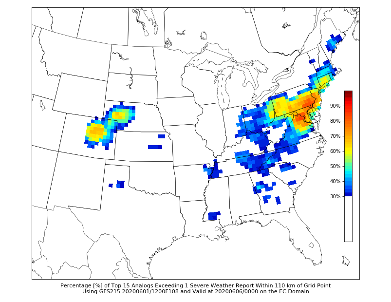
Look at hr108 on the 12z CIPS guidance
-
The 18z NAM has the axis of good parameters a bit closer to the DC metro this run.
-
I just re-read that and - Hail the size of comets.


