

ORH_wxman
-
Posts
93,099 -
Joined
-
Last visited
Content Type
Profiles
Blogs
Forums
American Weather
Media Demo
Store
Gallery
Everything posted by ORH_wxman
-
Dec 5/6th major coastal/ west Atlantic cyclogenesis ...?
ORH_wxman replied to Typhoon Tip's topic in New England
I think 12z is a touch more intense. -
Dec 5/6th major coastal/ west Atlantic cyclogenesis ...?
ORH_wxman replied to Typhoon Tip's topic in New England
It's almost identical to 06z...it looks maybe a hair slower but the same track. -
Dec 5/6th major coastal/ west Atlantic cyclogenesis ...?
ORH_wxman replied to Typhoon Tip's topic in New England
It's a stronger storm, but not necessarily west of 06z yet. -
Dec 5/6th major coastal/ west Atlantic cyclogenesis ...?
ORH_wxman replied to Typhoon Tip's topic in New England
Phasing is slightly better by 24h...so this should be a hair west of 06z on the euro. -
Dec 5/6th major coastal/ west Atlantic cyclogenesis ...?
ORH_wxman replied to Typhoon Tip's topic in New England
I believe it was the woodbury coop -
Dec 5/6th major coastal/ west Atlantic cyclogenesis ...?
ORH_wxman replied to Typhoon Tip's topic in New England
Euro looks slightly weaker with the southern stream at 12h vs the 06z run through 12h...not a big change though. -
Dec 5/6th major coastal/ west Atlantic cyclogenesis ...?
ORH_wxman replied to Typhoon Tip's topic in New England
Scooter just smashed his laptop over his snow blower. -
Dec 5/6th major coastal/ west Atlantic cyclogenesis ...?
ORH_wxman replied to Typhoon Tip's topic in New England
I made a map of it years ago for SNE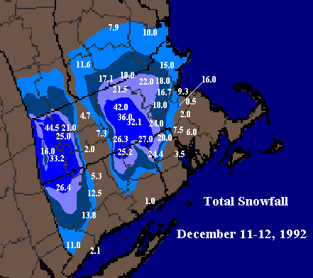
-
Dec 5/6th major coastal/ west Atlantic cyclogenesis ...?
ORH_wxman replied to Typhoon Tip's topic in New England
I've seen the herpes be pretty awful. That said, I kind of like the non-hydrostatic models in this one as we get inside 36 hours. They are going to be able to resolve that very intense (but localized) convection that will be occurring in this bombing low. -
Dec 5/6th major coastal/ west Atlantic cyclogenesis ...?
ORH_wxman replied to Typhoon Tip's topic in New England
It's interesting that it has the same band that the RGEM has at 33 hours where I was complaining about it having -1C 925temps and -3C 850 temps and keeping me rain....but the herpes has that same band as heavy snow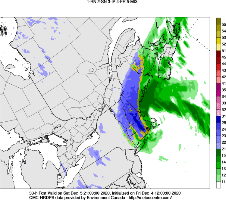
-
Dec 5/6th major coastal/ west Atlantic cyclogenesis ...?
ORH_wxman replied to Typhoon Tip's topic in New England
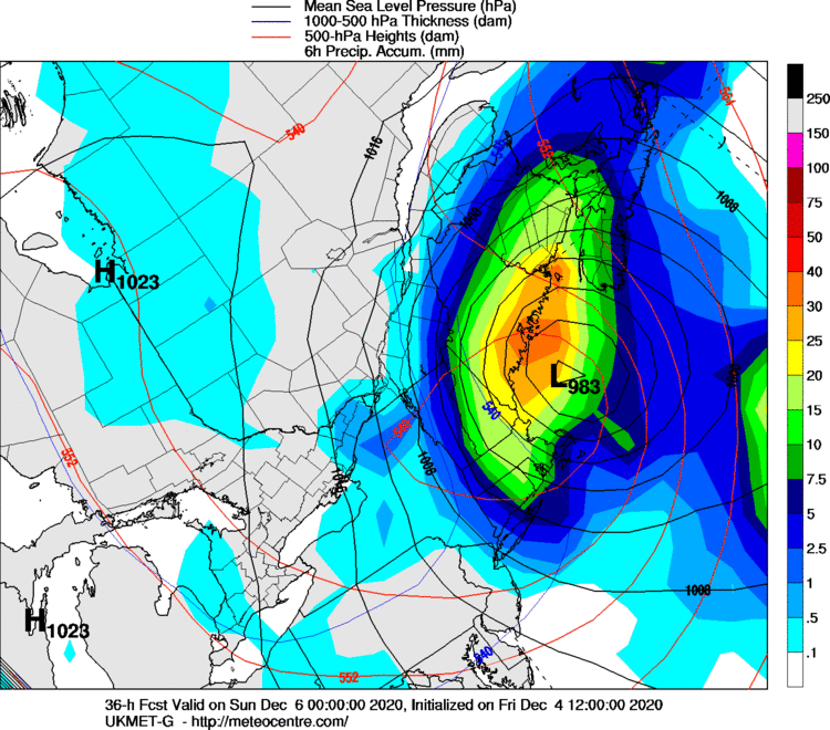
42h panel for the Mainers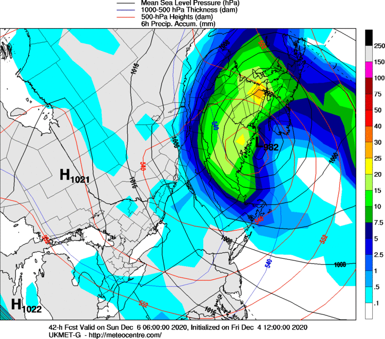
-
Dec 5/6th major coastal/ west Atlantic cyclogenesis ...?
ORH_wxman replied to Typhoon Tip's topic in New England
Ukie came west, but still definitely east of guidance like the RGEM/GFS....NAM was maybe slightly west of the Ukie.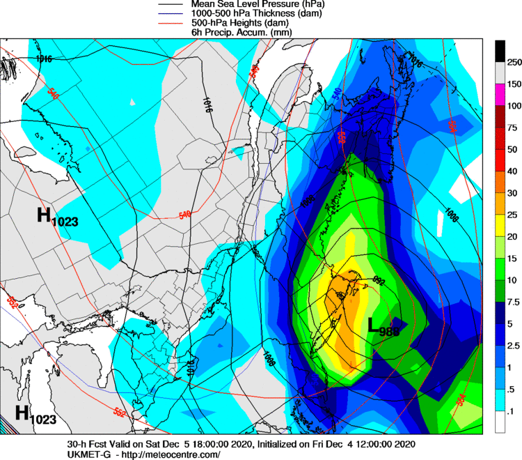
-
Dec 5/6th major coastal/ west Atlantic cyclogenesis ...?
ORH_wxman replied to Typhoon Tip's topic in New England
This is going to be an interesting storm to track from the pure precip rates standpoint and how it matches up with the ptype....I think there's going to be a very high correlation if I had to guess. Like the first 6-8 hours of this thing kind of slog along with moderate (to maybe low-end heavy) precip and that's when all the toaster baths are gonna happen. Then all of the sudden, those ridiculous echoes on radar rotate in and I can envision a ton of people posting that flakes are mixing in and then changing over. -
Dec 5/6th major coastal/ west Atlantic cyclogenesis ...?
ORH_wxman replied to Typhoon Tip's topic in New England
There is a 0% chance you'd be saying this if you were still in Franklin county. -
Dec 5/6th major coastal/ west Atlantic cyclogenesis ...?
ORH_wxman replied to Typhoon Tip's topic in New England
Never gets old....haha. My nirvana moment in that storm was while sitting in social studies class around 11am or thereabouts. The same thing happened in terms of gusts of wind when the changeover was happening. These big gusts of wind would "sweep" a blizzard of flakes across the soccer field/playground and into the window, then it would let up and go back to mostly rain. It did this for about 4-5 pulses over the span of 7-8 minutes until the final pulse permanently changed it over. We didn't get the fortune of having thunder at the changeover like you did, but we did get thunder that evening (prob around the time you changed over). -
Dec 5/6th major coastal/ west Atlantic cyclogenesis ...?
ORH_wxman replied to Typhoon Tip's topic in New England
I keep watching the H5-H7 track (they are almost the same since this goes nuts so fast)....having those go over the Cape is premium for a good chunk of interior SNE and I think having them exiting out into the gulf of maine signals at least a few hours nearer to the coast around or just north of BOS. -
Dec 5/6th major coastal/ west Atlantic cyclogenesis ...?
ORH_wxman replied to Typhoon Tip's topic in New England
This is going to implode inward at some point if these nuke solutions are right. The GFS will be too broad imho. -
Dec 5/6th major coastal/ west Atlantic cyclogenesis ...?
ORH_wxman replied to Typhoon Tip's topic in New England
Yeah GFS is slightly more phased at 24h....should be a tick west, which will match other 12z guidance better because the 06z GFS tracked this over ACK and outside the Cape. -
Dec 5/6th major coastal/ west Atlantic cyclogenesis ...?
ORH_wxman replied to Typhoon Tip's topic in New England
If we had a 12/9/05 airmass, we'd be looking at 15-20 easy where the max stripe goes...prob some 20+. This moves slower than that one. -
Dec 5/6th major coastal/ west Atlantic cyclogenesis ...?
ORH_wxman replied to Typhoon Tip's topic in New England
The former....it's like a 50-55 (10^-5/S) magnitude. -
Dec 5/6th major coastal/ west Atlantic cyclogenesis ...?
ORH_wxman replied to Typhoon Tip's topic in New England
You'd probably appreciate the RGEM 500mb map at 30 and 33 hours....that vortmax reminds me of a certain event.....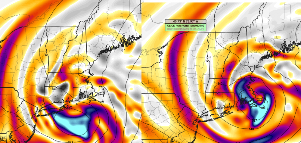
-
Dec 5/6th major coastal/ west Atlantic cyclogenesis ...?
ORH_wxman replied to Typhoon Tip's topic in New England
RGEM is still a furnace. Also more amped...buzzard bay track. Still weird to see the sfc so torched though....at 21z tomorrow, it has -1C 925 over my head with -3C 850 temps and it's like 37F, lol -
Dec 5/6th major coastal/ west Atlantic cyclogenesis ...?
ORH_wxman replied to Typhoon Tip's topic in New England
Yep, 12/23/97 -
Dec 5/6th major coastal/ west Atlantic cyclogenesis ...?
ORH_wxman replied to Typhoon Tip's topic in New England
Even the kuchera maps are pretty good....and they are pretty conservative in the marginal low level events. That's how obscene that run was.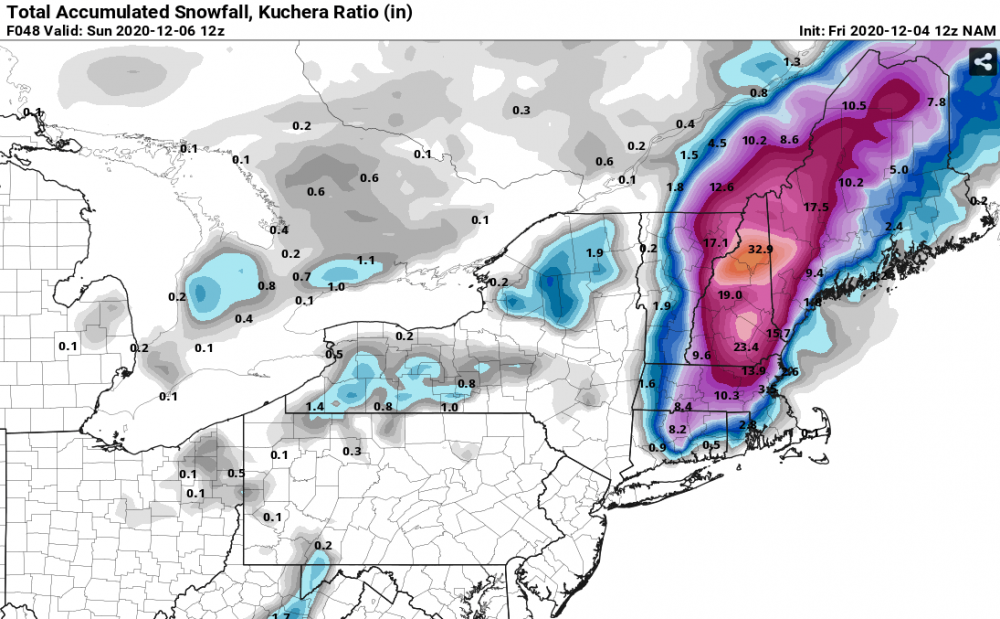
-
Dec 5/6th major coastal/ west Atlantic cyclogenesis ...?
ORH_wxman replied to Typhoon Tip's topic in New England
This is a ridiculous run for the lakes region in W ME over to Phin's/Alex's hood.


