ORH_wxman
-
Posts
93,099 -
Joined
-
Last visited
Content Type
Profiles
Blogs
Forums
American Weather
Media Demo
Store
Gallery
Everything posted by ORH_wxman
-
Looks a bit like the last 10 days of dec 2007 or so...there just enough WPO to push the lower heights further south into Canada and the western US. That was an above normal period for us but it did have some threats and a couple advisory events.
-
December 5-6, 2020 Storm Observations and Nowcast
ORH_wxman replied to Baroclinic Zone's topic in New England
This crap was like slime and then froze overnight. Back in holliston we got about 4” of Italian ice. But the piles make it look like double that because of the water content.
-
If you want to hone in on a narrower range, I feel like the best period for us is probably like 12/16-12/19. That’s when there’s some cold established nearby (or hopefully over us) and could work with an imperfect synoptic setup.
-
They didn’t. Unless maybe you live in Norfolk.
-
December 5-6, 2020 Storm Observations and Nowcast
ORH_wxman replied to Baroclinic Zone's topic in New England
Yeah you’re left with like these -5C needles falling into that deep 32-33F layer. Not a good combo for efficient accumulation is an understatement. -
December 5-6, 2020 Storm Observations and Nowcast
ORH_wxman replied to Baroclinic Zone's topic in New England
The lift was lowering throughout the event over E MA. There was prob more DGZ lift during the initial changeover than later on...maybe Chris or someone has easier access to the cross sections than I do at the moment, but I’m pretty sure i recall seeing the lift a bit deeper earlier in the event. Usually once you flip over to snow, keeping excellent DGZ isn’t a huge deal because your in the CCB and often advecting cold air into the system...but this was a unique system in which we were not so the issue ended up more glaring than it usually would be. -
December 5-6, 2020 Storm Observations and Nowcast
ORH_wxman replied to Baroclinic Zone's topic in New England
And the best zone that had decent lift in the DGZ was further west over ORH county into adjacent S NH...so they had the double advantage of better DGZ lift plus some elevation. It’s probably why you saw like 9-12 inches of snow there while Ray in Methuen was struggling to get 2”. You hardly ever see that type of gradient unless he was mostly raining which wasn’t the case. -
December 5-6, 2020 Storm Observations and Nowcast
ORH_wxman replied to Baroclinic Zone's topic in New England
Yeah this almost certainly a factor too. Even in warm spring storms, if you have a dry polar high sitting up there, it can be a nice source of drier dewpoints feeding into the storm to help cool the low levels even if temps were 55F the day before. There was probably a combo of factors that hurt further east. Less loft in the DGZ, lack of drier dewpoints up north to help advect in a source of lower level cooling. -
December 5-6, 2020 Storm Observations and Nowcast
ORH_wxman replied to Baroclinic Zone's topic in New England
Yeah I’m not sure. The temperature of the ice matters too. I’ll have to search for the paper I mentioned...I think I have it saved on my pc downstairs. It’s like my go-to source for this kind of stuff. It talks about everything including how you can get ice crystals in areas close to the ocean as low as -4C to -5C due to the salt nuclei being far more efficient at warmer temps. -
December 5-6, 2020 Storm Observations and Nowcast
ORH_wxman replied to Baroclinic Zone's topic in New England
Yeah if you’re throwing a bunch of marginal ice crystals at relatively warm temps (like around -5C as you said) into a layer at 32-33F, that sounds uglier than throwing a bunch of hooked dendrites at -10 to -14C into that same layer. -
December 5-6, 2020 Storm Observations and Nowcast
ORH_wxman replied to Baroclinic Zone's topic in New England
I have to go back and find that great paper about dendritic and ice crystal growth but I also remember from it that it talked about how the well-formed dendrites/ice crystals will latently cool more efficiently when they melt than marginal ice crystals. So kind of a double whammy there in a super marginal air mass. There was a ton of QPF that fell in the CCB...agreed on that. So it wasn’t like we got dried out over E MA. It just ended up basically being sleet ratios there. -
December 5-6, 2020 Storm Observations and Nowcast
ORH_wxman replied to Baroclinic Zone's topic in New England
Zwyts sent me a pretty sweet video of solid wind/snow combo. I told him I was glad in retrospect that you guys went with the more elevated zone vs lower down on skowhegan/Millinocket...being at 1200 feet ended up being a bigger deal than initially thought. Y’all hovered just below freezing which was huge. -
December 5-6, 2020 Storm Observations and Nowcast
ORH_wxman replied to Baroclinic Zone's topic in New England
I think the key is probably the DGZ lift. My guess is the best DGZ lift stayed near 495 and westward for most of the storm. It also coincided with the higher terrain so we saw a bigger elevation gradient than usual. But even a lot of 495 belt with modest elevation in the Littleton to Berlin to Hopkinton/Holliston zone saw 4-6”...it was kind of telling to me that once you got further east on 495 like over to Lowell and Lawrence that they really struggled and I’m wondering if the longitude there hurt with worse DGZ lift. -
December 5-6, 2020 Storm Observations and Nowcast
ORH_wxman replied to Baroclinic Zone's topic in New England
Phineas prob has 16-18? Could be more...Alex in the other side of the mountains looked like he did pretty well too though prob a bit less. Our N ORH county posters had 10-12...I measured just shy of 10” on winter hill on the north side of ORH. Back in Holliston we had about 4 inches of the densest/wettest snow I’ve seen. Randy/Zwyts chasing in eustis Maine prob had over a foot. -
December 5-6, 2020 Storm Observations and Nowcast
ORH_wxman replied to Baroclinic Zone's topic in New England
That was also a ridiculous cutter. It basically stalled up in Ontario. Pretty unique. When you have tropical dewpoints into northern Maine, there’s no escaping those cutters. -
December 5-6, 2020 Storm Observations and Nowcast
ORH_wxman replied to Baroclinic Zone's topic in New England
Yeah that is snowpack country there eastward into Maine because of the big CAD they get. The torches they get are usually brief, even in most cutters. -
December 5-6, 2020 Storm Observations and Nowcast
ORH_wxman replied to Baroclinic Zone's topic in New England
Yeah I was mostly commenting that the map got it right but prob not due to an exceptional skill there...it was wrong further southwest...even excluding elevated places like ORH (say, the 495 belt from maybe Berlin/Bolton down to Milford had solid advisory level snows 3-6” when the map was spitting out like an inch) But it was definitely far more accurate than the other clown maps which we knew would be too optimistic in this airmass. You're still going to defeat that map in the long run looking at soundings and analyzing the model. -
December 5-6, 2020 Storm Observations and Nowcast
ORH_wxman replied to Baroclinic Zone's topic in New England
Yeah I don’t think anyone would have forecasted 2” there based on the data we saw. Same reason I didn’t buy the 3-4” amounts it was spitting out for ORH. I figured at least 4-5” minimum for you (like what many got further south of you in the 495 belt). One of those weird events...I’m wondering if the longitude there hurt with the lift placement not being as much in the DGZ. Would be interesting to go back and look when this is over. -
December 5-6, 2020 Storm Observations and Nowcast
ORH_wxman replied to Baroclinic Zone's topic in New England
Ahh yes those piles were prob from the 3/4/19 storm. That was the best storm that winter. Dumped a widespread 8-16” for the eastern 2/3rds of SNE. -
December 5-6, 2020 Storm Observations and Nowcast
ORH_wxman replied to Baroclinic Zone's topic in New England
My guess is they had about 5 or 6 inches. Not too bad but I would’ve thought more of you asked me this morning when it was flipping pretty early. -
December 5-6, 2020 Storm Observations and Nowcast
ORH_wxman replied to Baroclinic Zone's topic in New England
When everyone was flipping to snow ahead of schedule I thought it was going to be a positive bust...LOL. Shows how quickly things can change. I was sure that the 128 belt was gonna get rocked. They were changing over around 2pm and it looked excellent for hours...but they just never mustered the intensity after the flip. The low level temps were a problem but I’m still surprised. I guess maybe the lift wasn’t quite lining up perfectly in DGZ which really helps in marginal setups. You need everything to go right...esp at lower elevations and perhaps that was the one ingredient missing in an otherwise perfect opportunity to overcome the marginal near-sfc layer. -
December 5-6, 2020 Storm Observations and Nowcast
ORH_wxman replied to Baroclinic Zone's topic in New England
Yep, 900+ feet in ORH. Paxton just west of ORH just reported 12.5”...they are up near 1200 feet. -
December 5-6, 2020 Storm Observations and Nowcast
ORH_wxman replied to Baroclinic Zone's topic in New England
Yeah I was wondering if the airport was running a degree warm or so. Several of the other mesosites around there got to 32 as well. -
It’s so-so. Today’s storm really messes up an otherwise great setup for Dec 7-8. We’ll see about 12/13ish...that could cut or it could end up ok...but will depend on nuances. Today’s guidance wants to lean cutter. Hopefully we get another chance behind that but a lot of uncertainty.
-
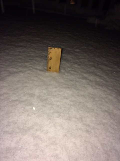
December 5-6, 2020 Storm Observations and Nowcast
ORH_wxman replied to Baroclinic Zone's topic in New England
Here Walt, I measured this about an hour ago