

ORH_wxman
-
Posts
93,099 -
Joined
-
Last visited
Content Type
Profiles
Blogs
Forums
American Weather
Media Demo
Store
Gallery
Everything posted by ORH_wxman
-
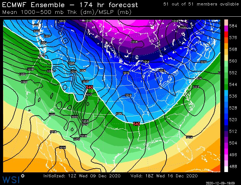
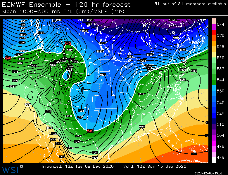
I would not be expecting a true PV split. Having it take some punches though is good...it is helping keep that blocking up there longer. If you recall, the models for a few days broke down the blocking very quickly and there were some minor freakouts in here about pig patterns returning. The PV will probably congeal back together again, so I don't expect January 2011 blocking. But every little bit helps.
-
It will be a cutter within a couple days, lol. But at the same time, some threat will probably appear of nowhere inside of 6 days. That seems to happen a lot in these blocky Nina patterns. At any rate, this is way better than a one-eyed pig pattern where you don't even need to really look at the models for any threats and instead you are staring at ensembles out to 360h hoping to see when it finally might break down. That feeling of hopelessness like we saw for long stretches last year.
-
Pretty classic Miller B sig.....hopefully it stays
-
I also expect modeling to be horrible for individual threats out in the medium range....remember, this is La Nina with some high arctic blocking. Probably the worst setup for model guidance to be accurate with individual storm threats. Too many S/Ws coming from terrible data coverage regions (this includes the satellite coverage which gets distorted up in the arctic).
-
Yep....without a massive standing PNA wave like 2015 or a 2010-2011 NAO block, you're always going to have some level of nuance that requires lining up for events. Those SWFE patterns in Dec '07 or '08 easily could have failed. This one could too, but my gut is that at least one of these works out in the next 2 weeks or so. It's active and there's legit cold pinned down into Canada.
-
Man, that block over the arctic ocean just rots the entire run basically. It does keep that PV pinned down in Canada....and with the NAO not hostile (even favorable at several intervals), it's not a bad look overall. It's a look that definitely provides a lot of chances. It's a very active flow. None of the timing was great this run, but that is small scale nuance that can change easily.
-
Get out in it saturday night and sunday morning....should be a solid event if you love 35F rain.
-
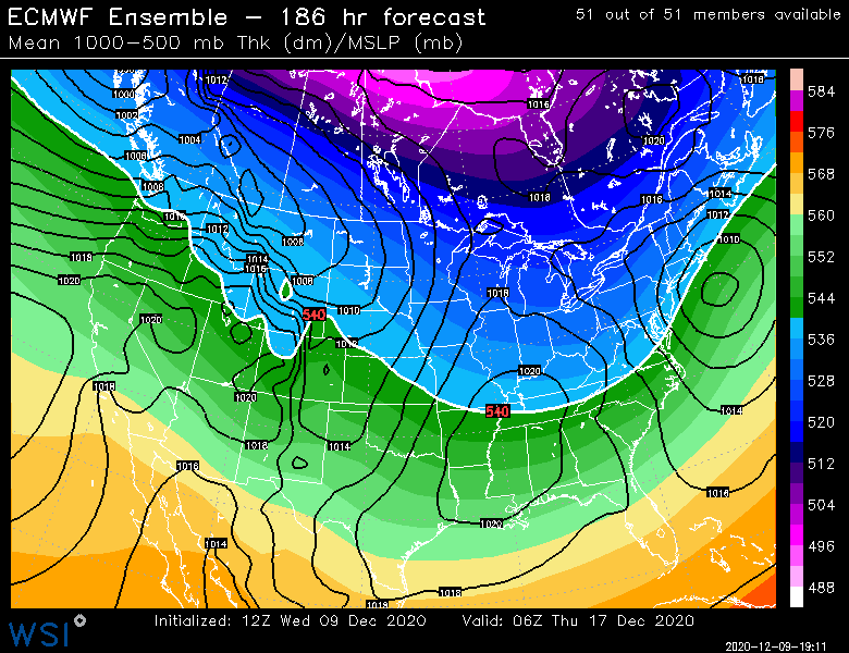
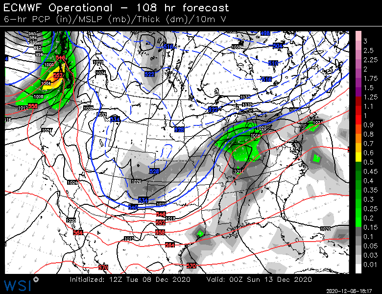
Almost was just a FROPA....not even a mild cutter. Kind of weird....but it all starts with the timing of the northern and southern stream shortwaves....they kind of were in phase with eachother so that's why we didn't see a nice event....we want the northern stream to outrun the southern and we'd get a really nice setup. Still a pretty favorable look though overall...I think we'd have more than one shot. Maybe 12/19ish too.
-
Euro is gonna go cutter for 12/16-17....not that it matters this far out....but no eye candy this run.
-
Still need to keep half an eye on it...if this whole thing presses more on Saturday leading into it, then there could be some legit icing concerns. I'm leaning against it for now, but we've seen it happen before. Esp for further inland, like ORH county into S NH.
-
Nice mesolow showing up this weekend....if we had cold air at the sfc more established beforehand, that would be a very bullish icing signal even into BOS for a time.
-
-
Yep, there's a lot of events that are not coastals that will hit our area and maybe not V NT or NH/ ME....things like clippers that track S of LI or even overrunning events that struggle to get warning snows north of central VT/NH. Also the occasional IVT that dumps a few inches. The Killington number definitely looks inflated unless maybe they were measuring near the 4k summit and perhaps it's only mildly inflated. But then it wouldn't be apples to apples comparison to other ski resorts since you shouldn't measure at the summit.
-
I like the 12/17 look the most (I've actually liked this period for days now...I think I was posting about 12/16-12/19 a few times)....EPS were pretty bullish on that one last night. But yeah, can't rule out the follow up wave on 12/15 yet.
-
Yes, last night it backed off some which was kind of surprising honestly....though 06z euro trended a little flatter again. We'll see if we can get one more push today otherwise I think it's like a 36-42F rain down here. Maybe 33F in the N ORH hills.
-
Yeah, the only complication is advecting in the colder air first before the storm starts....we're actually pretty mild on Friday before the storm. It could almost be the type of system where it gets colder as the event unfolds and the CAD is actively pressing southwest. My hope is that we see the arctic high press further on future runs, so that we're already in the cold airmass before the storm even arrives.
-
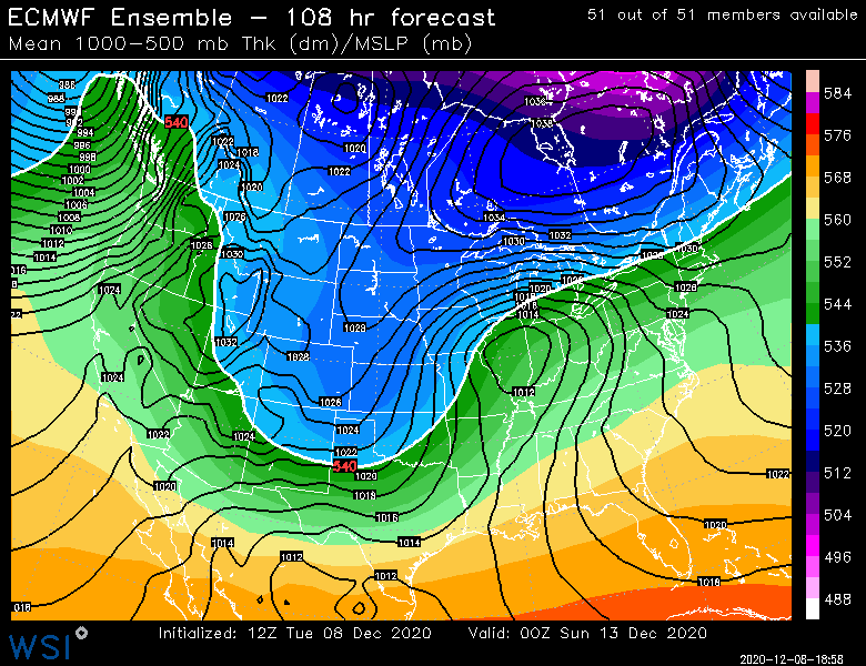
1040 arctic high is no joke either....at least it's better than tracking a straight cutter.
-
EPS came in flatter than previous runs....we'll see if we can push that arctic high south even more in the next couple days.
-
You might get decent snow this weekend too. One thing that will tak a while getting used to is not to fear modeled cutters as much....they often turn into what we're seeing on the Euro. It doesn't make a difference for MD, but in NE (esp NNE) it can go from 50F rainer to snowstorm in a couple cycles.
-
OR an obscene slug of 3" of qpf like Dec '08.
-
Nov 1921 repeat next Tuesday?
-
Euro is coming in pretty flat so far
-
I hope....lol....I still think we're prob screwed down here for this weekend, but NNE may end up pretty wintry on this one. But we may have a couple legit threats behind this one. That blocking lingers up in the arctic, so I won't be surprised to see a general trend more favorable during that period.
-
We'll see what the Euro does at 12z....but I'm somewhat on the more suppressed train at the moment where the sfc high builds down. I'd expect the GFS to be the last model to see it. 12z Ukie is building the high in out ahead of the system

-
I fully expect NNE to be locked into the cold at the surface in this one now....the only question iswhether the cold is deep enough so that it is more snow versus more sleet/ZR. Maybe the trend will reverse, but we've seen this movie many times. It will keep trending colder before it does the classic SWFE bump back north inside of 48 or 60 hours.


