ORH_wxman
-
Posts
93,099 -
Joined
-
Last visited
Content Type
Profiles
Blogs
Forums
American Weather
Media Demo
Store
Gallery
Everything posted by ORH_wxman
-
Dec 5/6th major coastal/ west Atlantic cyclogenesis ...?
ORH_wxman replied to Typhoon Tip's topic in New England
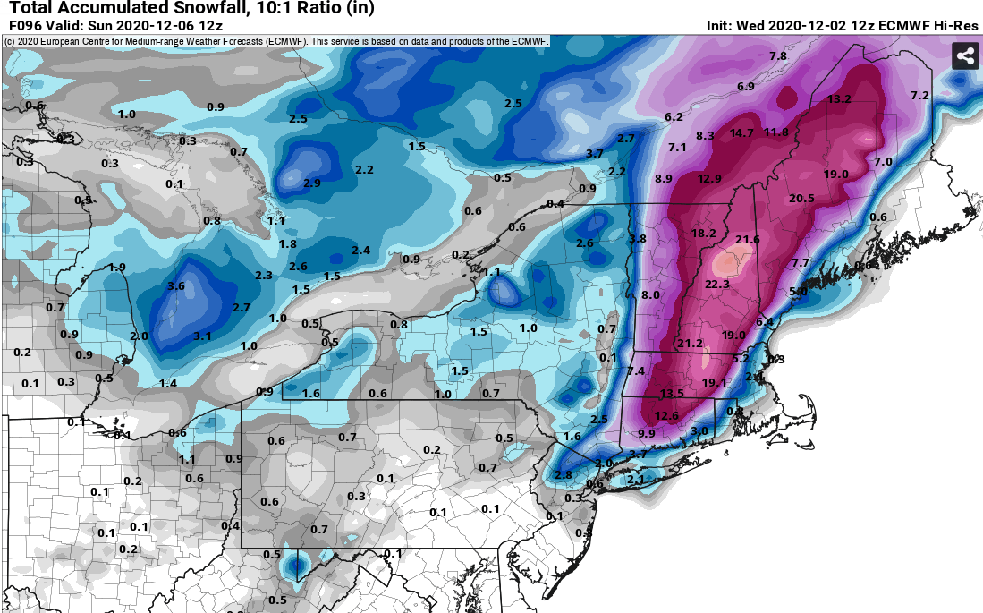
This is one of the worst ones I’ve seen in a while this close to the event. I mean, we’re only 3 days out and these models are almost behaving like they do 6 days out. They have no idea on how to handle the interaction of these two shortwaves. -
Dec 5/6th major coastal/ west Atlantic cyclogenesis ...?
ORH_wxman replied to Typhoon Tip's topic in New England
Looks like the GFS is going to basically whiff on phasing the two streams, lol. These models have no idea what is going on. So it’s going to be solely a southern stream storm on the GFS. -
Dec 5/6th major coastal/ west Atlantic cyclogenesis ...?
ORH_wxman replied to Typhoon Tip's topic in New England
RGEM went west of 18z. If you recall, 18z actually had decent snow near BOS. Now it’s interior SNE up into NNE/Maine. -
Dec 5/6th major coastal/ west Atlantic cyclogenesis ...?
ORH_wxman replied to Typhoon Tip's topic in New England
I do wish it was a non-event with the southern stream still trapped in the southwest. That would really help Dec7-8 But we’ve also known for like a week how putrid the airmass was. I think we were even saying like 5 days ago that 12/5 was a Hail Mary for SNE. -
Dec 5/6th major coastal/ west Atlantic cyclogenesis ...?
ORH_wxman replied to Typhoon Tip's topic in New England
Yeah it’s kind of a shit sandwich in SNE in this one. A zonked system jack-potting Saranac Lake NY on one end and a whiff on the other...and then some in-between runs of garbage 37F and rain. We need the exotic nuclear bomb solutions with a pretty narrow track to work in SNE. Up north obviously has some more wiggle room. Esp N NH into interior ME. -
Dec 5/6th major coastal/ west Atlantic cyclogenesis ...?
ORH_wxman replied to Typhoon Tip's topic in New England
Certainly in this storm it is. I feel like at this point given the volatility in model solutions, we just treat them all as ensemble members. I’d give the euro more weight than models like the RGEM at 72+ hours but definitely not biting on it hook, line, and sinker. -
Dec 5/6th major coastal/ west Atlantic cyclogenesis ...?
ORH_wxman replied to Typhoon Tip's topic in New England
Lol at the euro. It makes swings like the NAM now. What in the hell is it doing? -
Dec 5/6th major coastal/ west Atlantic cyclogenesis ...?
ORH_wxman replied to Typhoon Tip's topic in New England
Wow a DT post...just caught up in the thread. I feel like it’s been years. Hope you’re doing well. Anyways, this model battle it definitely interesting. I feel like the gfs took a step toward the euro at 18z but the question is which one trends more. I figure the euro is likely to trend a little more east and less phasing. But whether we get a 50/50 compromise or a 70/30 or 80/20 makes a huge difference. -
Dec 5/6th major coastal/ west Atlantic cyclogenesis ...?
ORH_wxman replied to Typhoon Tip's topic in New England
The upper level system is pretty strong still to the southwest so if we had another frame or two, it might still enhance the CCB across new england. Still not the obscenity that 12z was, but the slowness of this run prevents us from seeing the full potential because that probably happens at 90 hours or so. -
We got a new thread for that threat
-
Dec 5/6th major coastal/ west Atlantic cyclogenesis ...?
ORH_wxman replied to Typhoon Tip's topic in New England
Not as dynamic as 12z....owing to the southern stream staying separate for longer. Still a pretty impressive system, but not the utter nuclear bomb that 12z was. -
Dec 5/6th major coastal/ west Atlantic cyclogenesis ...?
ORH_wxman replied to Typhoon Tip's topic in New England
Yeah this is a really late phase....slower system too. -
Dec 5/6th major coastal/ west Atlantic cyclogenesis ...?
ORH_wxman replied to Typhoon Tip's topic in New England
18z NAM southern stream dragging its heels big time vs 12z. This will either be well east of 12z or end up as solely a southern stream event this run (think more like the GFS type solutions we've seen the past day or two) -
Yeah your top storms in Jackson will be way better than N Conway. Some of those long duration firehose storms give almost grotesque snowfall totals there. Like I think the late February 2010 storm put up some ridiculous number in Randolph.
-
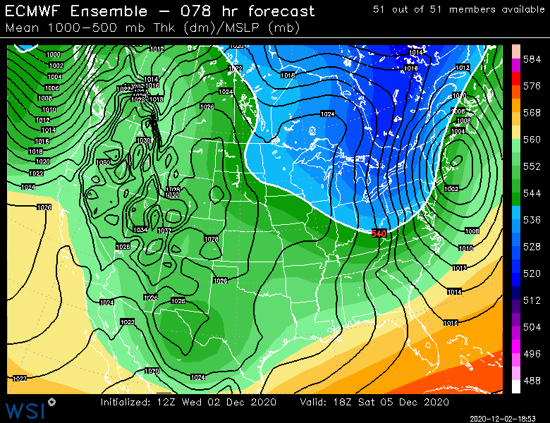
Yeah EPS is pretty similar...slightly E which is par for the course.
-
Yeah if you were making a first WAG right now, it would probably not be a terrible map. I'd prob be more cautious in SNE than anywhere, but there's a chance the interior could see something.
-
Yeah I'd prob blend the two...I think that map is too low based on those ridiculous dynamics (esp interior elevations).
-
Nice little west-based NAO block on the Euro after that storm....that could make things interesting for the 12/10-12/15 period.
-
I'd feel pretty good for the white mountain gang over eastward into interior Maine....that swath has the most wiggle room.
-
Yeah but it's been later and later on each euro run for the past 3-4 runs. At some point the trend will stop. Hopefully it goes one more tick and then stops, lol.
-
Compromise incoming....Scooter steals western area's snow again.
-
Saved in this thread for later laughs

-
Hubbdave jackpot
-
Yeah I'm not expecting this to actually verify, but it's a fun solution to look at.
-
Lol, abslute destruction in interior SNE.