

ORH_wxman
-
Posts
93,099 -
Joined
-
Last visited
Content Type
Profiles
Blogs
Forums
American Weather
Media Demo
Store
Gallery
Everything posted by ORH_wxman
-
Dec 5/6th major coastal/ west Atlantic cyclogenesis ...?
ORH_wxman replied to Typhoon Tip's topic in New England
NAM looks a bit better at 27h vs 18z. Starting to phase a bit more. I’m not sure if it’s going to be back at the 12z solution but it should be west of 18z anyway. -
Dec 5/6th major coastal/ west Atlantic cyclogenesis ...?
ORH_wxman replied to Typhoon Tip's topic in New England
There’s still a lot of wave spacing issues with that one...BUT....without getting too off topic for this current thread (I’ll indulge for a second since we’re in the dead zone before 00z runs), the 18z euro solution of phasing all 3 shortwaves allows the system to “wait out” the 12/5-6 system for an extra tick or two, and that could be enough to allow enough ridging to form between the two systems (Tip pointed out the ridging showing up in NJ just a few min ago). If that can happen, then it becomes a serious threat for the I-95 corridor mid-Atlantic perhaps all the way into New England....baroclincity has already been rejuvenated by 90h down in the Carolinas and VA so it has a path to significance. But it will require that phasing and delay for the wave-spacing to become a little more palatable. -
Dec 5/6th major coastal/ west Atlantic cyclogenesis ...?
ORH_wxman replied to Typhoon Tip's topic in New England
Slightly OT, but... You prob didn’t see this, but the 18z euro only goes out to 90h so we can’t see beyond this, but it’s phasing 3 shortwaves now behind the 12/5-6 system, most aggressive I’ve seen.....imagine what this would be if we can get the ULL to lift out in the maritimes fast enough.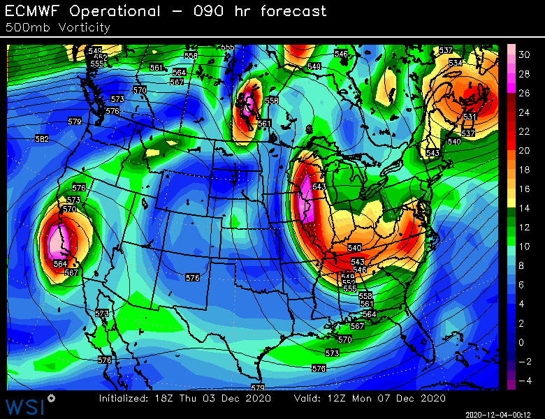
-
Dec 5/6th major coastal/ west Atlantic cyclogenesis ...?
ORH_wxman replied to Typhoon Tip's topic in New England
WSI. They are the crude low resolution maps but they come out really fast. Powderfreak posted the hi-res from weatherbell I think. -
Dec 5/6th major coastal/ west Atlantic cyclogenesis ...?
ORH_wxman replied to Typhoon Tip's topic in New England
Nah it was similar to 12z. The 12z run did this too with the sfc temps. If you see 925 temps near 0C then it could be an issue but they are clearly going a tick or two below that which says to me this is 31F underneath that type of CCB. Now if rates aren’t huge, then it would definitely be more of an issue. -
Dec 5/6th major coastal/ west Atlantic cyclogenesis ...?
ORH_wxman replied to Typhoon Tip's topic in New England
Lol. Nice disconnect on this map vs the other 10 to 1 maps. The reality is probably in between these two. I’m not sure why the euro is trying to hold sfc temps at like 35F while under a CCB with 925 temps of -1C to -2C and 6 hourly qpf of 0.75-1.00....meaning extremely heavy rates. -
Dec 5/6th major coastal/ west Atlantic cyclogenesis ...?
ORH_wxman replied to Typhoon Tip's topic in New England
I’d be worried from hippy to runnaway. I wouldn’t be writing it off there this soon though. But we’ll want to see the phasing show just a smidge more life on the 00z suite. -
Dec 5/6th major coastal/ west Atlantic cyclogenesis ...?
ORH_wxman replied to Typhoon Tip's topic in New England
Ray gets a nice stinger CCB at the end. -
Dec 5/6th major coastal/ west Atlantic cyclogenesis ...?
ORH_wxman replied to Typhoon Tip's topic in New England
You don’t need to make a final call tonight. I would at least wait until 12z runs tomorrow. -
Dec 5/6th major coastal/ west Atlantic cyclogenesis ...?
ORH_wxman replied to Typhoon Tip's topic in New England
-
Dec 5/6th major coastal/ west Atlantic cyclogenesis ...?
ORH_wxman replied to Typhoon Tip's topic in New England
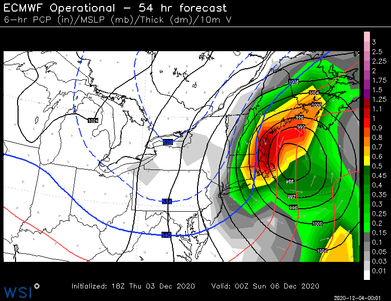
You can see slightly less phasing at 42 hours as a result of the weaker northern stream earlier. So this will be a tick east. -
Dec 5/6th major coastal/ west Atlantic cyclogenesis ...?
ORH_wxman replied to Typhoon Tip's topic in New England
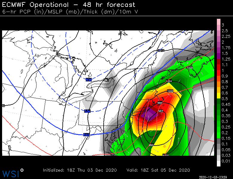
There’s basically no change through 24h. Northern stream may be just ever so slightly weaker so it could end up a shade east but i don’t expect a drastic jump this run unless something else happens late in the game. -
Looks like a period of low heights in AK for late dec/early Jan but then it breaks down after that Have to watch WPO though...might stay negative so that’s important...if it does in tandem with Aleutian ridge, we can still live on that even with some lower heights in AK. Ala ‘07-08.
-
Dec 5/6th major coastal/ west Atlantic cyclogenesis ...?
ORH_wxman replied to Typhoon Tip's topic in New England
18z RPM was out of Scooter's basement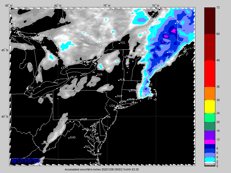
-
Dec 5/6th major coastal/ west Atlantic cyclogenesis ...?
ORH_wxman replied to Typhoon Tip's topic in New England
The NAM actually might whiff this run. -
Dec 5/6th major coastal/ west Atlantic cyclogenesis ...?
ORH_wxman replied to Typhoon Tip's topic in New England
18z NAM is going to be east I think....southern vort dragging like an anchor again -
Dec 5/6th major coastal/ west Atlantic cyclogenesis ...?
ORH_wxman replied to Typhoon Tip's topic in New England
I think the menu on Super Tecmo Bowl was more organized than ecmwf.int -
Dec 5/6th major coastal/ west Atlantic cyclogenesis ...?
ORH_wxman replied to Typhoon Tip's topic in New England
Yeah I don't want much further east where I am either...I'm in a pretty good spot on the Euro. -
Dec 5/6th major coastal/ west Atlantic cyclogenesis ...?
ORH_wxman replied to Typhoon Tip's topic in New England
Updated clown...dryslot posted one that wasn't done yet.....i think these numbers are too generous even for that solution, but they show the axis well of where the best stuff is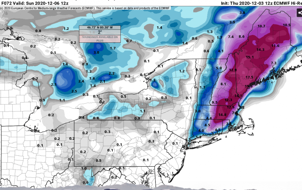
-
Dec 5/6th major coastal/ west Atlantic cyclogenesis ...?
ORH_wxman replied to Typhoon Tip's topic in New England
With those precip rates I wouldn't worry...it would def rain for a while at the beginning but the CCB stuff would flip to parachutes. -
Dec 5/6th major coastal/ west Atlantic cyclogenesis ...?
ORH_wxman replied to Typhoon Tip's topic in New England
That's the peak run for interior SNE. Prob won't get better than that. -
Dec 5/6th major coastal/ west Atlantic cyclogenesis ...?
ORH_wxman replied to Typhoon Tip's topic in New England
It's going to be a nuke this run. -
Dec 5/6th major coastal/ west Atlantic cyclogenesis ...?
ORH_wxman replied to Typhoon Tip's topic in New England
15z RPM run from Jerry's basement?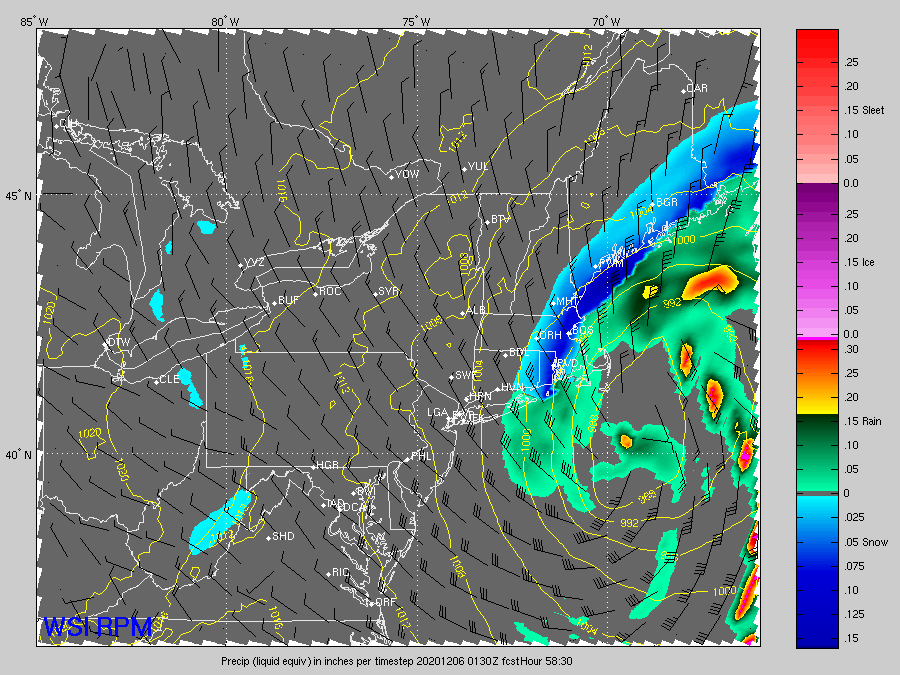
-
Dec 5/6th major coastal/ west Atlantic cyclogenesis ...?
ORH_wxman replied to Typhoon Tip's topic in New England
Euro's def going to be east at least somewhat...that southern vort is dragging -
Dec 5/6th major coastal/ west Atlantic cyclogenesis ...?
ORH_wxman replied to Typhoon Tip's topic in New England
Yeah and it's all about the lift. You stick 50 micobars per second up at 600mb....those aggregates that start happening when they reach the melting layer are going to be so dense/thick (due to it being such heavy precip), it's going to cause the latent cooling to go into overdirve to melt all of them before reaching the ground.


