ORH_wxman
-
Posts
93,099 -
Joined
-
Last visited
Content Type
Profiles
Blogs
Forums
American Weather
Media Demo
Store
Gallery
Everything posted by ORH_wxman
-
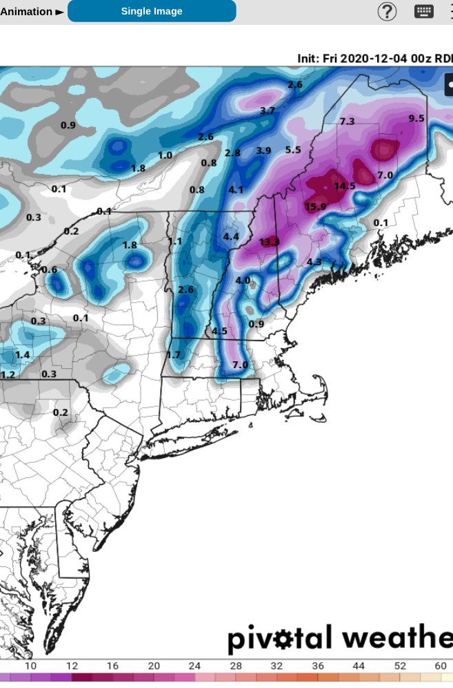
Dec 5/6th major coastal/ west Atlantic cyclogenesis ...?
ORH_wxman replied to Typhoon Tip's topic in New England
There's a big stinger this run for NE MA and into SE NH/S ME. Kind of rots there for a few hours. -
Dec 5/6th major coastal/ west Atlantic cyclogenesis ...?
ORH_wxman replied to Typhoon Tip's topic in New England
This run is definitely colder at 925 than 06z....prob due to the huge dynamics. That is good to see though. -
Dec 5/6th major coastal/ west Atlantic cyclogenesis ...?
ORH_wxman replied to Typhoon Tip's topic in New England
Good god....that is a ridiculous run for like ORH/495 belt through 33 hours...and getting up into a good chunk of NH and S ME. -
Dec 5/6th major coastal/ west Atlantic cyclogenesis ...?
ORH_wxman replied to Typhoon Tip's topic in New England
Yeah I envision the snowfall aspect being like a 4-6 hour event for the meat of it over lower elevations....maybe an extra couple hours for places like ORH. It's obviously a tough forecast still because we know that there is potential to dump 10" in 5-6 hours, but that also there is potential that it only accumulates to like 3-4" of slop. -
Dec 5/6th major coastal/ west Atlantic cyclogenesis ...?
ORH_wxman replied to Typhoon Tip's topic in New England
The 12z NAM should continue to tick west here back toward the other guidance. 06z made a nice jump but was still pretty far east. This looks better down south with the southern stream. -
Dec 5/6th major coastal/ west Atlantic cyclogenesis ...?
ORH_wxman replied to Typhoon Tip's topic in New England
Pretty solid tick east from 06z....which was admittedly a western outlier compared to other guidance. That would obliterate ORH and my hood I think. -
Dec 5/6th major coastal/ west Atlantic cyclogenesis ...?
ORH_wxman replied to Typhoon Tip's topic in New England
That's kind of 12/9/05 style....the initial band set up west of ORH but then as it collapsed E it went insane as the storm basically imploded the atmosphere over upper cape/buzzards bay. -
Dec 5/6th major coastal/ west Atlantic cyclogenesis ...?
ORH_wxman replied to Typhoon Tip's topic in New England
The biggest thing I’d worry about is that the low levels start pretty warm. 925 is still warm on Saturday morning so there’s definitely going to be big dynamics needed. It looks like we get them but I could see it taking a little while to flip. -
Dec 5/6th major coastal/ west Atlantic cyclogenesis ...?
ORH_wxman replied to Typhoon Tip's topic in New England
Anyways, I’m prob not staying up for the euro. But I wouldn’t expect a large change. Given the 00z trend I wouldn’t be surprised if it tickled back a little west like 12z. -
Dec 5/6th major coastal/ west Atlantic cyclogenesis ...?
ORH_wxman replied to Typhoon Tip's topic in New England
That H5 is deepening pretty fast on the Ukie. Good spot too for an intense band over interior SNE for a time. The non-hydrostatics will hopefully be more useful starting tomorrow. Globals will have a hard time resolving something this tightly wound. -
Dec 5/6th major coastal/ west Atlantic cyclogenesis ...?
ORH_wxman replied to Typhoon Tip's topic in New England
Crappy Ukie maps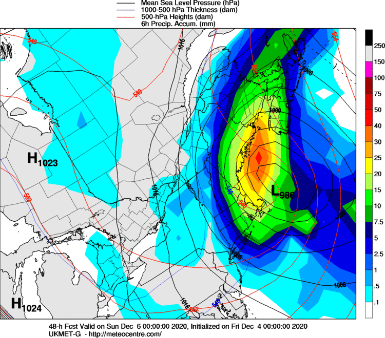
-
Dec 5/6th major coastal/ west Atlantic cyclogenesis ...?
ORH_wxman replied to Typhoon Tip's topic in New England
Yeah my first winter posting was ‘04-05. I feel old now, lol. -
Dec 5/6th major coastal/ west Atlantic cyclogenesis ...?
ORH_wxman replied to Typhoon Tip's topic in New England
Yeah, man....I don’t go quite that far back, but I remember him before he was on-air. I think prob around the time he graduated (PSU I think?) -
Dec 5/6th major coastal/ west Atlantic cyclogenesis ...?
ORH_wxman replied to Typhoon Tip's topic in New England
This forecast sucks for being so close. Trying to remember the last time the models were so volatile inside of 48h -
Dec 5/6th major coastal/ west Atlantic cyclogenesis ...?
ORH_wxman replied to Typhoon Tip's topic in New England
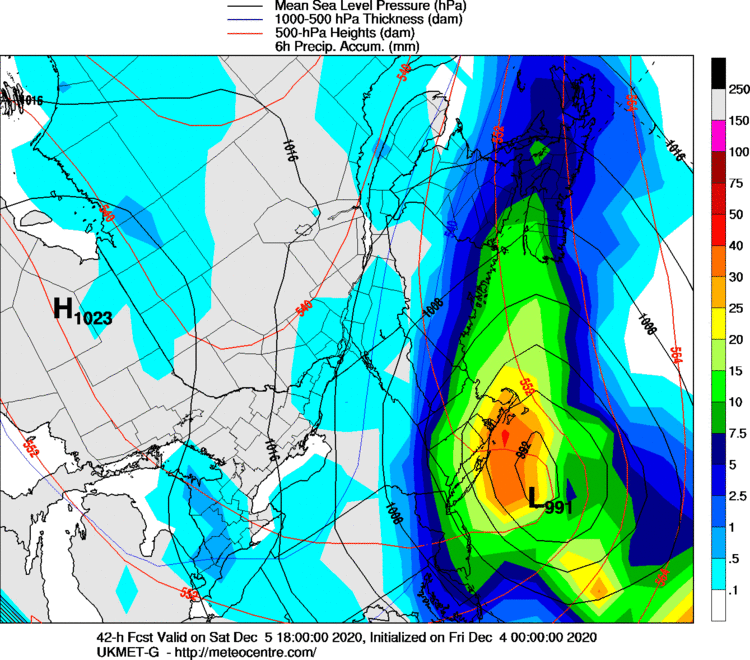
You can get it out to 36h on plymouth state pretty early but then we have to wait until like 1140-1145 on meteocentre to get anything else including precip maps Here’s 850 and 500 at 36h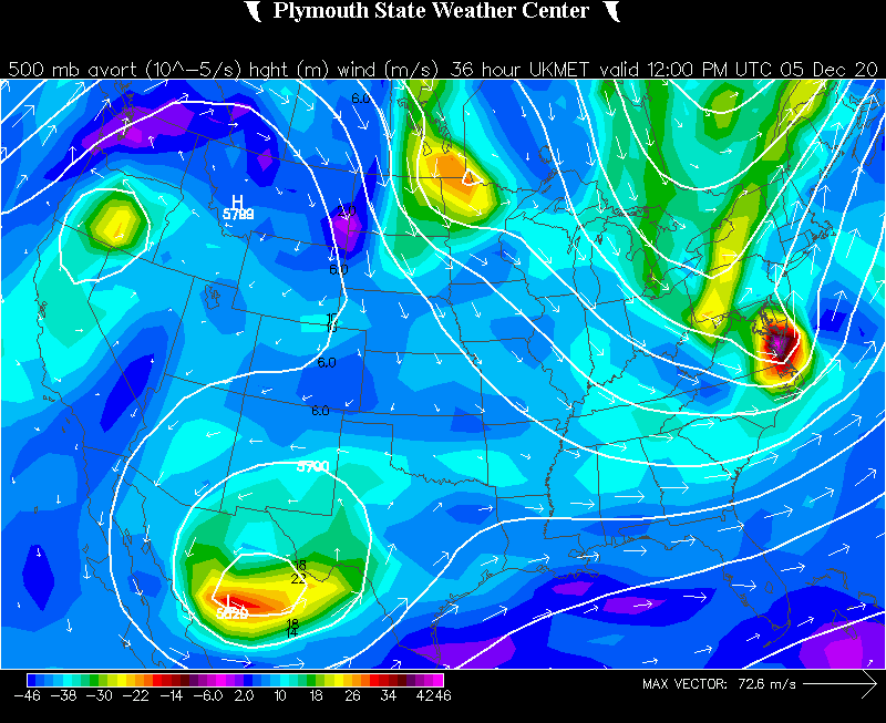
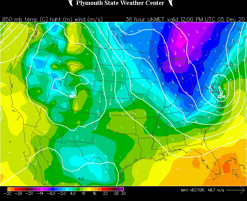
-
Dec 5/6th major coastal/ west Atlantic cyclogenesis ...?
ORH_wxman replied to Typhoon Tip's topic in New England
Yeah maybe technically on the slp track but I’m looking aloft where it matters most for who gets snow and how much. -
Dec 5/6th major coastal/ west Atlantic cyclogenesis ...?
ORH_wxman replied to Typhoon Tip's topic in New England
So we’ve got 3 trends west (NAM, RGEM, and GFS...4 if we count icon) and 1 E at 00z (RPM) GFS def the west outlier at the moment. -
Dec 5/6th major coastal/ west Atlantic cyclogenesis ...?
ORH_wxman replied to Typhoon Tip's topic in New England
There are definitely issues with this airmass. We’ve been skeptical of snow for a week now because of it...but if you get a CCB like the rgem shows, I’d have a hard time believing it doesn’t snow right down to low elevations that get underneath that intense lift. RGEM even had warm low levels in the October storm too. I remember it being a warm outlier so not sure if there is something going on there. Its worth noting though that the euro 2m temps are pretty warm too. But the 925 temps on the euro were colder than the RGEM. -
Dec 5/6th major coastal/ west Atlantic cyclogenesis ...?
ORH_wxman replied to Typhoon Tip's topic in New England
Rgem has some funny looking clown maps with that warmish low level
-
Dec 5/6th major coastal/ west Atlantic cyclogenesis ...?
ORH_wxman replied to Typhoon Tip's topic in New England
It’s really struggling in the lower levels even though it has like 850 temps of -5C in the CCB lol. Kind of weird, but I’d think that would be pretty good for a lot of people who get under that CCB. That’s intense. -
Dec 5/6th major coastal/ west Atlantic cyclogenesis ...?
ORH_wxman replied to Typhoon Tip's topic in New England
RGEM is looking a bit more amped than 18z through 21 hours. -
Dec 5/6th major coastal/ west Atlantic cyclogenesis ...?
ORH_wxman replied to Typhoon Tip's topic in New England
Meh, these are non-hydrostatic models that are producing some of these really ugly solutions. I haven’t seen this from any of the globals yet. NAM actually did tick slightly better from 18z. I know the rpm didn’t, but I’d want to see some higher end guidance before reading too much into it. I like non-hydrostatic models in these types of storms once we are close in, but sometimes they can go haywire when over 36h out. -
Dec 5/6th major coastal/ west Atlantic cyclogenesis ...?
ORH_wxman replied to Typhoon Tip's topic in New England
RPM looks worse than 21z. Not the right direction. -
Dec 5/6th major coastal/ west Atlantic cyclogenesis ...?
ORH_wxman replied to Typhoon Tip's topic in New England
Yeah you have to go to downeast Maine to get anything. 3km is going to produce a bit better. -
Dec 5/6th major coastal/ west Atlantic cyclogenesis ...?
ORH_wxman replied to Typhoon Tip's topic in New England
Still pretty damned putrid on the NAM. Slight improvement.