ORH_wxman
-
Posts
93,092 -
Joined
-
Last visited
Content Type
Profiles
Blogs
Forums
American Weather
Media Demo
Store
Gallery
Everything posted by ORH_wxman
-
Dec 5/6th major coastal/ west Atlantic cyclogenesis ...?
ORH_wxman replied to Typhoon Tip's topic in New England
Union Station right there. -
Dec 5/6th major coastal/ west Atlantic cyclogenesis ...?
ORH_wxman replied to Typhoon Tip's topic in New England
Yeah a lot of MAULish soundings showing up. -
Dec 5/6th major coastal/ west Atlantic cyclogenesis ...?
ORH_wxman replied to Typhoon Tip's topic in New England
I'd think you'll probably at least get a couple inches there at the end. Potential is there for more, but it all depends on how fast this whole thing explodes off to our east and exactly where it tracks too...along if there is a semi-stall as it maxes out and H5 reaches its peak height falls....you may have to watch for some pretty big wind gusts there too as it goes nuts....SE areas have more potential for that. -
Dec 5/6th major coastal/ west Atlantic cyclogenesis ...?
ORH_wxman replied to Typhoon Tip's topic in New England
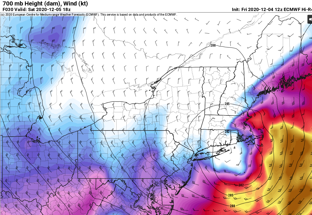
Here's ORH on the 3km NAM at the same time....you can see the lift lines up a bit better. So they'd probably be maximizing dendrites here.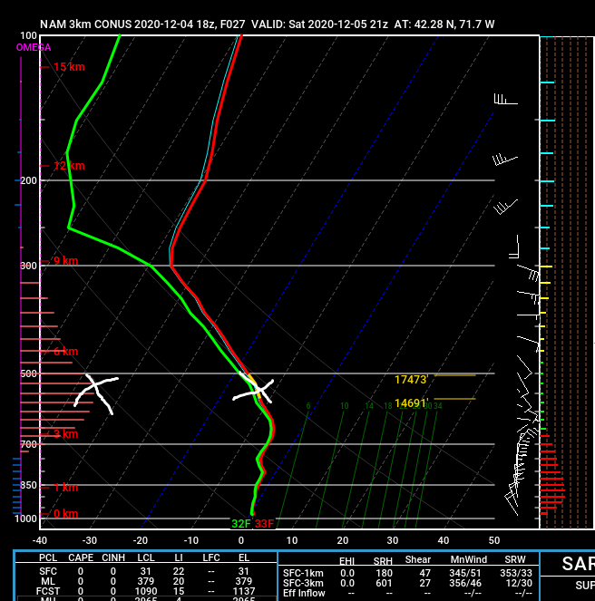
-
Dec 5/6th major coastal/ west Atlantic cyclogenesis ...?
ORH_wxman replied to Typhoon Tip's topic in New England
Yeah....on the 3km NAM, you are close but just below the crosshair.....the bars on the left are omega. I marked max omega with an "x" and then you match it up with the temp profile to the right....you can see it's just below the bext SGZ, but it's still like -10C so that's gonna be pretty decent,....and you still have good lift above the max lift region. Ideally the max lift would be a touch higher, but that will still be pretty solid.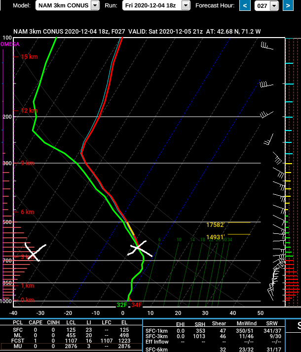
-
Dec 5/6th major coastal/ west Atlantic cyclogenesis ...?
ORH_wxman replied to Typhoon Tip's topic in New England
This one might be even worse paste....the only question is if you get as much snow as that one....it's not implausible It's a huge weenie run for you...you get hammered by the CCB/deform in the evening as it slows down in the Gulf of Maine just NE of the Cape. -
Dec 5/6th major coastal/ west Atlantic cyclogenesis ...?
ORH_wxman replied to Typhoon Tip's topic in New England
BOS gets a nice bone thrown to it around 5-9pm....pretty intense stinger on the CCB. This run slows down a little vs 12z as its tracking across the Cape and northeast which helps the CCB really go to town over E MA than some of the other guidance. -
Dec 5/6th major coastal/ west Atlantic cyclogenesis ...?
ORH_wxman replied to Typhoon Tip's topic in New England
Welcome....I don't think this is too similar to the Mar '18 storms....maybe the closest match would have been the Mar 7-8 storm which had all the power outages. But this storm is going to be even warmer at the onset, so there's going to be a long period of rain before any changeover....esp in SE MA. If you are in upper SE MA like near Foxoborough, you'll change over a bit earlier than everyone else down there and could grab several inches. -
Dec 5/6th major coastal/ west Atlantic cyclogenesis ...?
ORH_wxman replied to Typhoon Tip's topic in New England
It’s def gonna be slow once you are like inside of 495ish and def 128 I think. Heck, even ORH might take a little while with a lot of rain during the morning. If ORH is ripping snow by 10-11am, that will be a good sign for prob the 128-495 belt. If the 128 BOS suburbs are ripping by 18-20z then that is a good sign for BOS to potentially grab advisory type snows. The window for BOS is prob like 5pm to 10pm or something like that with a stinger tail on the CCB. -
Dec 5/6th major coastal/ west Atlantic cyclogenesis ...?
ORH_wxman replied to Typhoon Tip's topic in New England
I remember we were like "good thing the wind turned more northerly and cooled it into the upper 20s for the second half of the storm"....otherwise it might have flattened the whole forest. -
Dec 5/6th major coastal/ west Atlantic cyclogenesis ...?
ORH_wxman replied to Typhoon Tip's topic in New England
Oh yeah, if I was making an official forecast, I'd prob go like 10-20 or something....keep the range a little bit wide. I'm always leery of the last second tickle east on these compact systems. -
Dec 5/6th major coastal/ west Atlantic cyclogenesis ...?
ORH_wxman replied to Typhoon Tip's topic in New England
Unless this shifts east, I'd be really surprised if he doesn't crack 15"....that wind direction is good there. NE and then N to eventually NW. Plus he won't have to "waste" any qpf on rain. -
Dec 5/6th major coastal/ west Atlantic cyclogenesis ...?
ORH_wxman replied to Typhoon Tip's topic in New England
Ask Ekster about trees snapping behind his house after like 2-3" of glop partway into the 1/14/08 storm in Attleboro.....it was like 2am and he's saying shotguns blasts are going off behind his house from like 2" of waterlogged cement, LOL. -
Dec 5/6th major coastal/ west Atlantic cyclogenesis ...?
ORH_wxman replied to Typhoon Tip's topic in New England
I mean, that's basically how the dryslot filled in on 12/9/05....it was like convective cells feeding into the CCB band and the whole thing just kept strengthening and expanding, lol. That's really the uncertainty in the forecast....how the "stinger" potentially develops in the late afternoon/early evening. -
Dec 5/6th major coastal/ west Atlantic cyclogenesis ...?
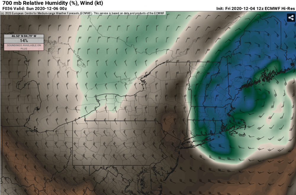
ORH_wxman replied to Typhoon Tip's topic in New England
Here's the 30h height field, plus 30 and 36 hour RH fields....it's moving E between 30 and 36h...so metrowest may get into the good stuff for a time....but you can def see that it's prob dryslotted out to like rt 128 at 18z tomorrow.
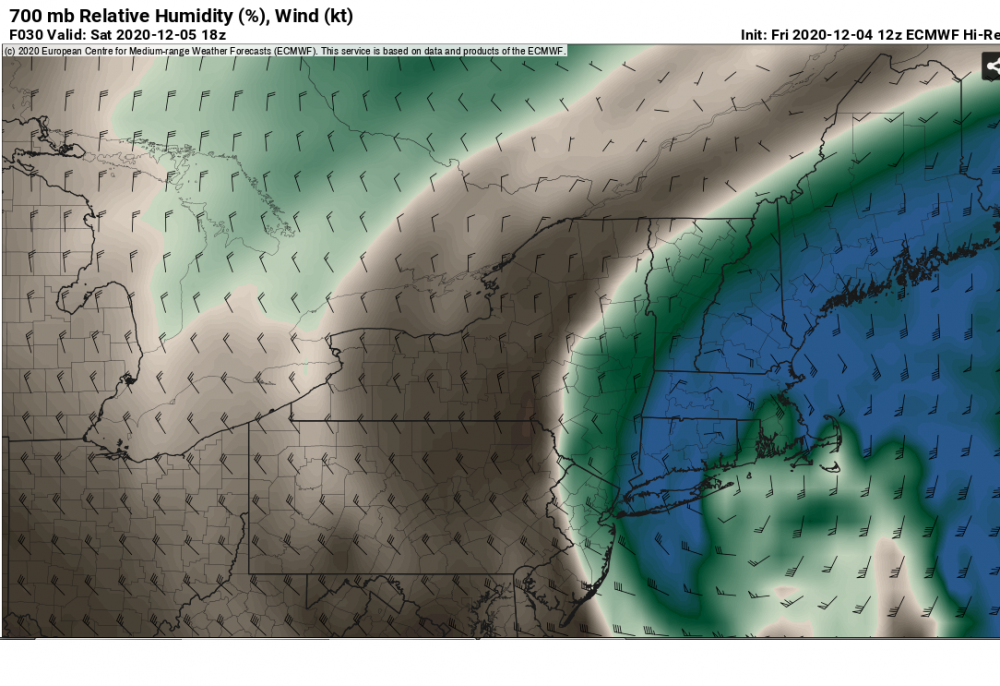
-
Dec 5/6th major coastal/ west Atlantic cyclogenesis ...?
ORH_wxman replied to Typhoon Tip's topic in New England
3/30/97 -
Dec 5/6th major coastal/ west Atlantic cyclogenesis ...?
ORH_wxman replied to Typhoon Tip's topic in New England
Best chance for BOS area I think is evening when that stinger rotates through....hopefully it is still very intense. If it is, they could see 2-3 hours of pretty good stuff. -
Dec 5/6th major coastal/ west Atlantic cyclogenesis ...?
ORH_wxman replied to Typhoon Tip's topic in New England
The airmass was a lot better in the Halloween event though.....funny we are saying that for a 12/5 storm. But yeah, once this CCB gets cranking and the storm is imploding over the Cape and just north, that is when near BOS could rip for a time. It will only happen though if were seeing huge UVVs. They may be rotting west of BOS metro for a while in late afternoon. -
Dec 5/6th major coastal/ west Atlantic cyclogenesis ...?
ORH_wxman replied to Typhoon Tip's topic in New England
I think 12z is a touch more intense. -
Dec 5/6th major coastal/ west Atlantic cyclogenesis ...?
ORH_wxman replied to Typhoon Tip's topic in New England
It's almost identical to 06z...it looks maybe a hair slower but the same track. -
Dec 5/6th major coastal/ west Atlantic cyclogenesis ...?
ORH_wxman replied to Typhoon Tip's topic in New England
It's a stronger storm, but not necessarily west of 06z yet. -
Dec 5/6th major coastal/ west Atlantic cyclogenesis ...?
ORH_wxman replied to Typhoon Tip's topic in New England
Phasing is slightly better by 24h...so this should be a hair west of 06z on the euro. -
Dec 5/6th major coastal/ west Atlantic cyclogenesis ...?
ORH_wxman replied to Typhoon Tip's topic in New England
I believe it was the woodbury coop -
Dec 5/6th major coastal/ west Atlantic cyclogenesis ...?
ORH_wxman replied to Typhoon Tip's topic in New England
Euro looks slightly weaker with the southern stream at 12h vs the 06z run through 12h...not a big change though. -
Dec 5/6th major coastal/ west Atlantic cyclogenesis ...?
ORH_wxman replied to Typhoon Tip's topic in New England
Scooter just smashed his laptop over his snow blower.