

ORH_wxman
-
Posts
93,092 -
Joined
-
Last visited
Content Type
Profiles
Blogs
Forums
American Weather
Media Demo
Store
Gallery
Everything posted by ORH_wxman
-
Active mid December with multiple event potential
ORH_wxman replied to Typhoon Tip's topic in New England
That is an UGLY GFS suite tonight. But we’ll see if it’s supported or not by other guidance. GGEM so far says no....84h NAM (if you want to count that) didn’t support it either. -
Active mid December with multiple event potential
ORH_wxman replied to Typhoon Tip's topic in New England
Ray smoking cirrus this run. Lol This thing got kicked east so fast compared to the prior runs. -
Active mid December with multiple event potential
ORH_wxman replied to Typhoon Tip's topic in New England
I don’t think Monday makes a big difference. Regardless, this is a philly special this run. -
Active mid December with multiple event potential
ORH_wxman replied to Typhoon Tip's topic in New England
This run won’t be as amped as 18z. Can already tell by 78h. -
My guess is it probably doesn’t beat climo...or if it does, just barely maybe due to some minor skill a month out in longwave patterns.
-
Active mid December with multiple event potential
ORH_wxman replied to Typhoon Tip's topic in New England
Yep. Not a single run from them I’ve seen that wanted to bring that sucker northwest. Ukie too. -
Active mid December with multiple event potential
ORH_wxman replied to Typhoon Tip's topic in New England
RGEM still not biting on Monday. -
Active mid December with multiple event potential
ORH_wxman replied to Typhoon Tip's topic in New England
If I was at PSU in UNV and over to IPT I’d be feeling pretty good. -
Active mid December with multiple event potential
ORH_wxman replied to Typhoon Tip's topic in New England
12z Reggie wasn’t on board either. Kind of skeptical of that threat but who knows. Sometimes a sneaky band on northern edge could produce a couple inches. -
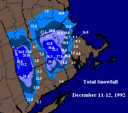
Yeah the gradient was insane. Just the perfect storm of conditions to create it. That was the storm where I first learned that the CRV was not as good for snow as Worcester. I had always assumed they were just as good or even better because they were further west. But when I found out they hardly had anything in that storm, I started paying attention more to the totals out there going forward and it surprised me how often they had less. I wasn’t acutely aware yet of how relative terrain worked.
-
-
Active mid December with multiple event potential
ORH_wxman replied to Typhoon Tip's topic in New England
Only acceptable at a first order site now. Spotter/coop is your max depth during the storm unless it’s longer than 24h then you can clear. I think that’s what it is now...I feel like it changes a lot, lol. -
Active mid December with multiple event potential
ORH_wxman replied to Typhoon Tip's topic in New England
It was actually a good defense by him...he said something like “that measurement in Wilmington is old school. The spotters have recently been advised to not clear every 6 hours but the top airport sites still do. The measurement is just like you’d see at an airport.” Im paraphrasing there but he basically was talking about how it was kind of arbitrary that spotter and coop measurements all of the sudden shouldn’t clear every 6 hours. Now advised just to take peak depth on the snowboard in a 24 hour period. You can clear after 24h. -
Active mid December with multiple event potential
ORH_wxman replied to Typhoon Tip's topic in New England
Pete B defended Ray’s measurement on the air in that one, lol. -
Active mid December with multiple event potential
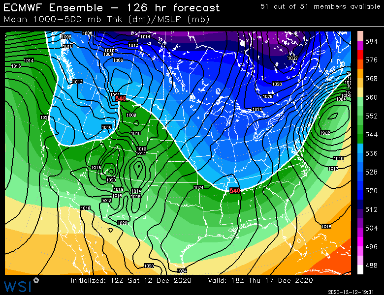
ORH_wxman replied to Typhoon Tip's topic in New England
EPS at 120-126. That’s a better look than the OP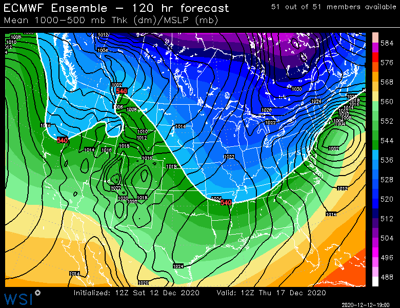
-
Active mid December with multiple event potential
ORH_wxman replied to Typhoon Tip's topic in New England
That and just look at the trough orientation to our west. This is pretty deep and going negative more than any of our whiffs. It’s certainly possible but I’d bet more on a N bump than a S one on that look. -
Active mid December with multiple event potential
ORH_wxman replied to Typhoon Tip's topic in New England
No reason to panic at all because of a single run that is like 75 miles from destroying SNE at day 5. At the end of the day, I’m still pretty sure we’re going to be glad we have a potent block. Hard for me to ignore how this looks to our west. -
Active mid December with multiple event potential
ORH_wxman replied to Typhoon Tip's topic in New England
When I saw this map at 96h, I was thinking it could be really zonked.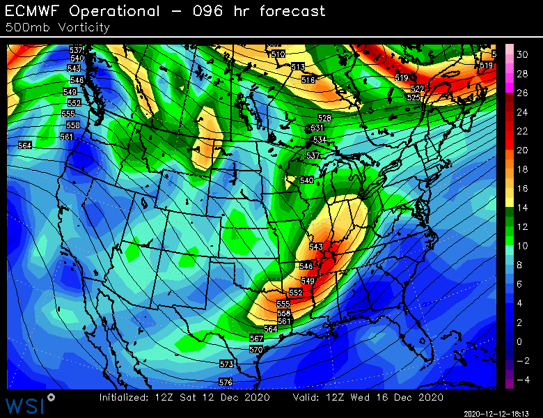
-
Active mid December with multiple event potential
ORH_wxman replied to Typhoon Tip's topic in New England
No you’re thinking of feb 25-26, 2010. Feb 10, 2010 was the epic bust where all the schools and workplaces shut down the night before and we got like 2-3” of slop. Different setup though. It was a deep cutoff low. -
Active mid December with multiple event potential
ORH_wxman replied to Typhoon Tip's topic in New England
After the 850 line was already passing PHL at 108. Color me a bit skeptical of the shortwave giving out that quickly. -
Active mid December with multiple event potential
ORH_wxman replied to Typhoon Tip's topic in New England
Thing was so zonked at 96-102. Then it just dies, lol. -
Active mid December with multiple event potential
ORH_wxman replied to Typhoon Tip's topic in New England
Lol I might ha e spoken too soon. Gets totally shoved east. -
Active mid December with multiple event potential
ORH_wxman replied to Typhoon Tip's topic in New England
Euro def won’t be the Ukie -
Active mid December with multiple event potential
ORH_wxman replied to Typhoon Tip's topic in New England
Ukie is somewhat suppressed and not that potent.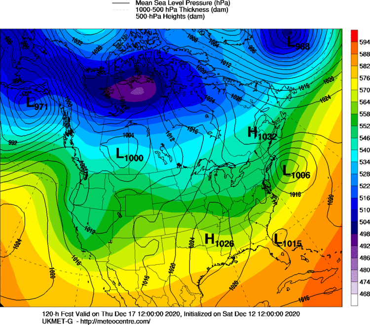
-
Active mid December with multiple event potential
ORH_wxman replied to Typhoon Tip's topic in New England
The Monday storm is a good example of the difference between a nuanced thread-the-needle setup and what is being modeled for Wednesday night/Thursday. You have excellent model agreement 5 days out on the latter threat while you have models all over the map from a 4-6” event to nothing at all on a 54 hour forecast for Monday.


