ORH_wxman
-
Posts
93,099 -
Joined
-
Last visited
Content Type
Profiles
Blogs
Forums
American Weather
Media Demo
Store
Gallery
Everything posted by ORH_wxman
-
Active mid December with multiple event potential
ORH_wxman replied to Typhoon Tip's topic in New England
Or maybe lemon meringue...but gotta watch out for the blow off. -
Active mid December with multiple event potential
ORH_wxman replied to Typhoon Tip's topic in New England
Still looking more robust than 18z. There’s significantly more downstream ridging this run through 36h. The confluence in northern Nova Scotia is holding about the same though so we’ll see what happens when this stronger wave interacts with it. -
Active mid December with multiple event potential
ORH_wxman replied to Typhoon Tip's topic in New England
It’s good to get new blood in the forum. But there’s a learning curve as well. Everyone was a newbie weenie at some point in their forum life. -
Active mid December with multiple event potential
ORH_wxman replied to Typhoon Tip's topic in New England
Seems like mostly newbies...they’ll get the hang of it eventually. -
Active mid December with multiple event potential
ORH_wxman replied to Typhoon Tip's topic in New England
NAM is definitely more amped down south through 24h, but I’m not gonna pretend to know what the QPF will do. -
Active mid December with multiple event potential
ORH_wxman replied to Typhoon Tip's topic in New England
Lol I forgot some dates. Esp if they were misses it’s easier. I’ll say the one time vividly recall a convective blob robbing he conveyor a bit was Feb 28-Mar 1, 2005. The forecast was for 8-12 and a massive blob of convection formed over LI and tracked over far SE Ma and the cape and Plymouth got like 13” in 3 hours out of it. But it was at the expense of the interior which was originally predicted to jackpot. We still did ok but we got like 6-7” instead of the bigger numbers. We tracked that one back on WWBB and the late messenger was all over that blob and predicting a huge SE MA positive bust. The upper air in that one though was far weaker with the vort and s/w and rounding a much deeper ULL in the lakes. So I don’t think it’s a good analog. The upper forcing was definitely weaker overall allowing convection to disrupt it easier. -
Active mid December with multiple event potential
ORH_wxman replied to Typhoon Tip's topic in New England
I’m not really buying the blob idea. Maybe if a whole bunch of mesos start showing a weak occluded mess, then I’ll buy it more. I’m trying to think of a good analog for an H5 look like this that didn’t hit us hard. I can’t come up with one...doesn’t mean they don’t exist though but I haven’t found it. -
Active mid December with multiple event potential
ORH_wxman replied to Typhoon Tip's topic in New England
They look NW if anything 12z on top, 18z bottom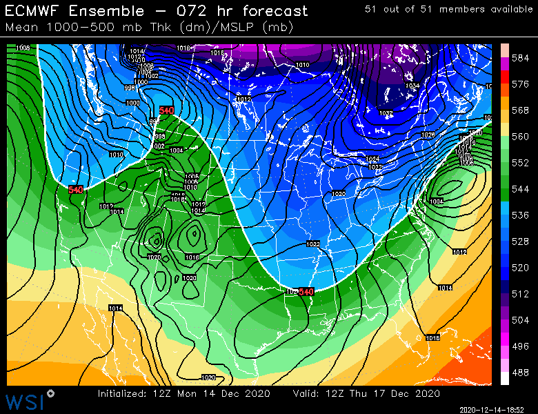
-
Active mid December with multiple event potential
ORH_wxman replied to Typhoon Tip's topic in New England
Yeah it’s possible. If it is, then the non-hydrostatic models should start showing this even more than regular global models ala euro. Still a bit out of their wheelhouse but the nonhydrostatics have been pretty far NW. -
Active mid December with multiple event potential
ORH_wxman replied to Typhoon Tip's topic in New England
If it’s legit then we should see the non-hydrostatic models start doing it even more than the hydrostatics as we get closer. So those will be the ones to watch. Deep convection like that will be handled worse by the hydrostatic models. -
Active mid December with multiple event potential
ORH_wxman replied to Typhoon Tip's topic in New England
I will take my chances with this look
-
Active mid December with multiple event potential
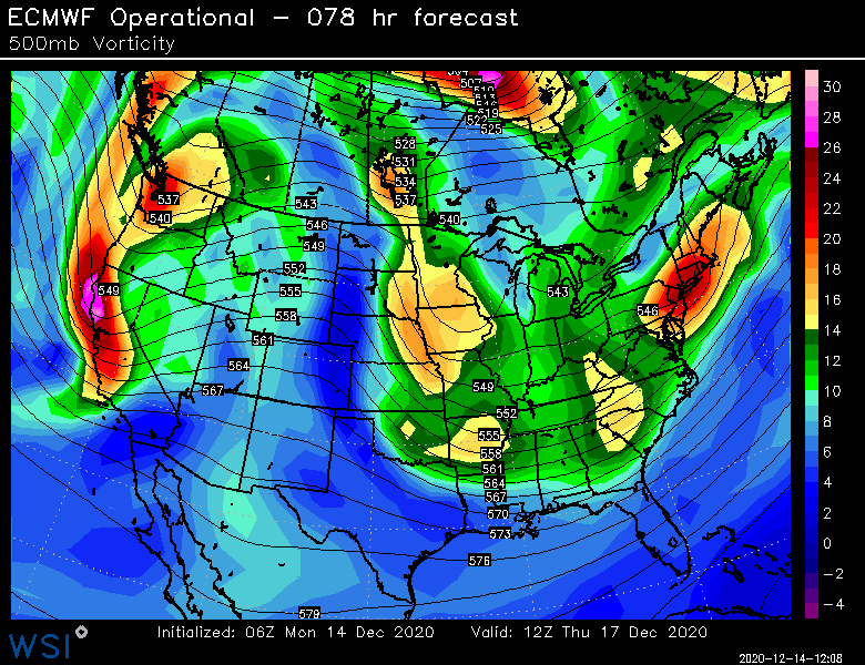
ORH_wxman replied to Typhoon Tip's topic in New England
Look at how much bigger the convective blob out there than 12z. Much stronger. Seems like it disrupted the WCB maybe at the last second. I was happy with that trend otherwise. H5 deeper and better kink in isoheights as it passes over us. -
Active mid December with multiple event potential
ORH_wxman replied to Typhoon Tip's topic in New England
QPF queens won’t like this run. Not going crazy on the WCB but I think it’s better than 12z with all the features that matter. -
Active mid December with multiple event potential
ORH_wxman replied to Typhoon Tip's topic in New England
18z Euro coming in a tick NW -
Active mid December with multiple event potential
ORH_wxman replied to Typhoon Tip's topic in New England
GFS will start to get a clue once at 24-36h out. -
Active mid December with multiple event potential
ORH_wxman replied to Typhoon Tip's topic in New England
Reggie is pretty tucked. Tracks almost over ACK. -
Active mid December with multiple event potential
ORH_wxman replied to Typhoon Tip's topic in New England
A stretched out upper level trough is actually pretty classic for a norlun sig...so I could def see some steady light to occasionally moderate snows rotting for several hours after the main CCB has moved out. No Kevin, they won’t go until Friday. -
Active mid December with multiple event potential
ORH_wxman replied to Typhoon Tip's topic in New England
Looks better for you than 12z since you get in on prolonged banding. -
December 14th Light Snow Event Observations
ORH_wxman replied to The 4 Seasons's topic in New England
Steady light snow but not really sticking. A little bit to the mulch. -
Active mid December with multiple event potential
ORH_wxman replied to Typhoon Tip's topic in New England
NAM looks less amped than 12z which should not be a surprise given its northern outlier status. -
Active mid December with multiple event potential
ORH_wxman replied to Typhoon Tip's topic in New England
Yeah you were really close to where 925mb RH started to drop off on the OP run so near the MA/NH border and northward would start having problems with LL dry air. 12z EPS looked better up there. -
Active mid December with multiple event potential
ORH_wxman replied to Typhoon Tip's topic in New England
Yeah the euro would prob have a filthy band in the pike to rt 2 region based on the MLs -
Active mid December with multiple event potential
ORH_wxman replied to Typhoon Tip's topic in New England
I saw that. So the “about to be defunct” GFS is the one not agreeing with any other guidance. -
Active mid December with multiple event potential
ORH_wxman replied to Typhoon Tip's topic in New England
Just catching up on 12z stuff after being on road all morning. I see the GFS is still clueless. Euro OP went a hair south but still have the zonked NAM and the Ukmet/Rgem/GGEM in between. -
Active mid December with multiple event potential
ORH_wxman replied to Typhoon Tip's topic in New England
Nice...deformed over SNE