ORH_wxman
-
Posts
93,099 -
Joined
-
Last visited
Content Type
Profiles
Blogs
Forums
American Weather
Media Demo
Store
Gallery
Everything posted by ORH_wxman
-
Active mid December with multiple event potential
ORH_wxman replied to Typhoon Tip's topic in New England
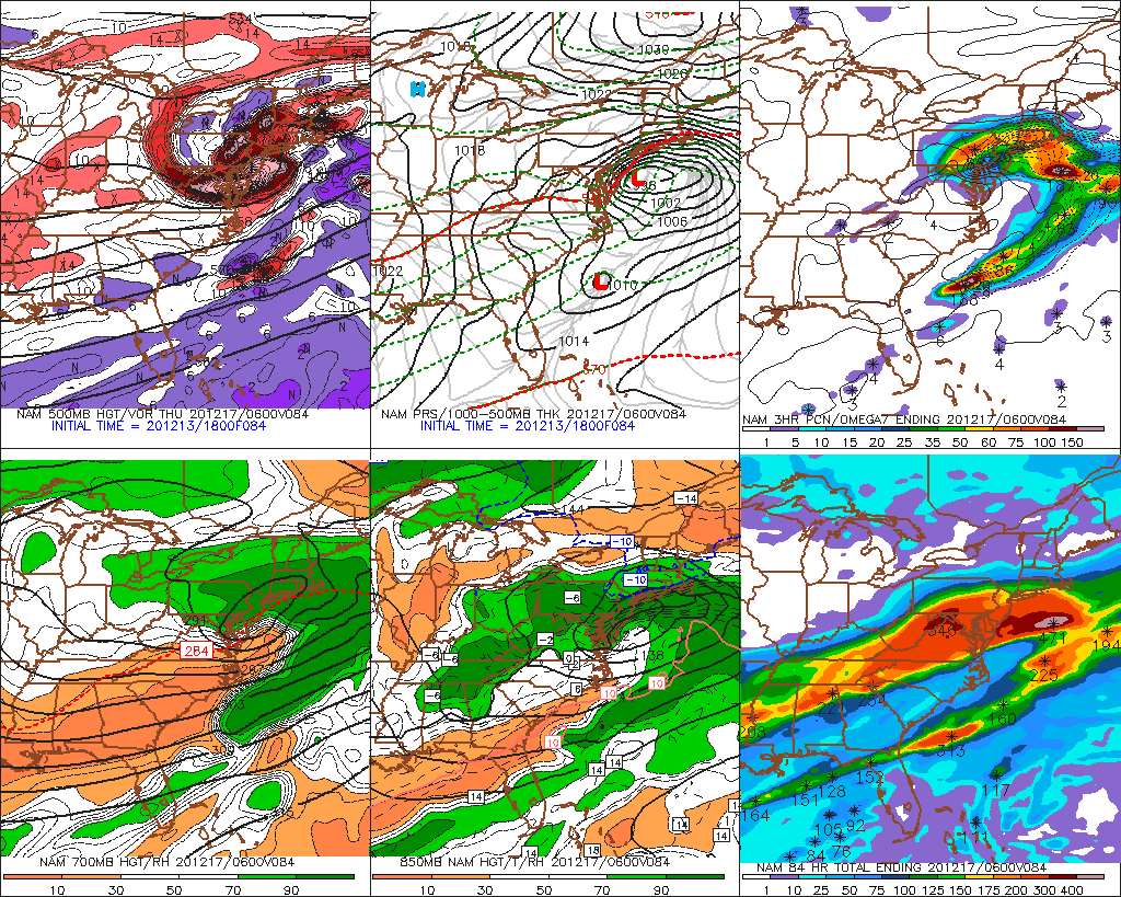
Too bad we didn’t have another panel of the NAM. Classic 84h NAM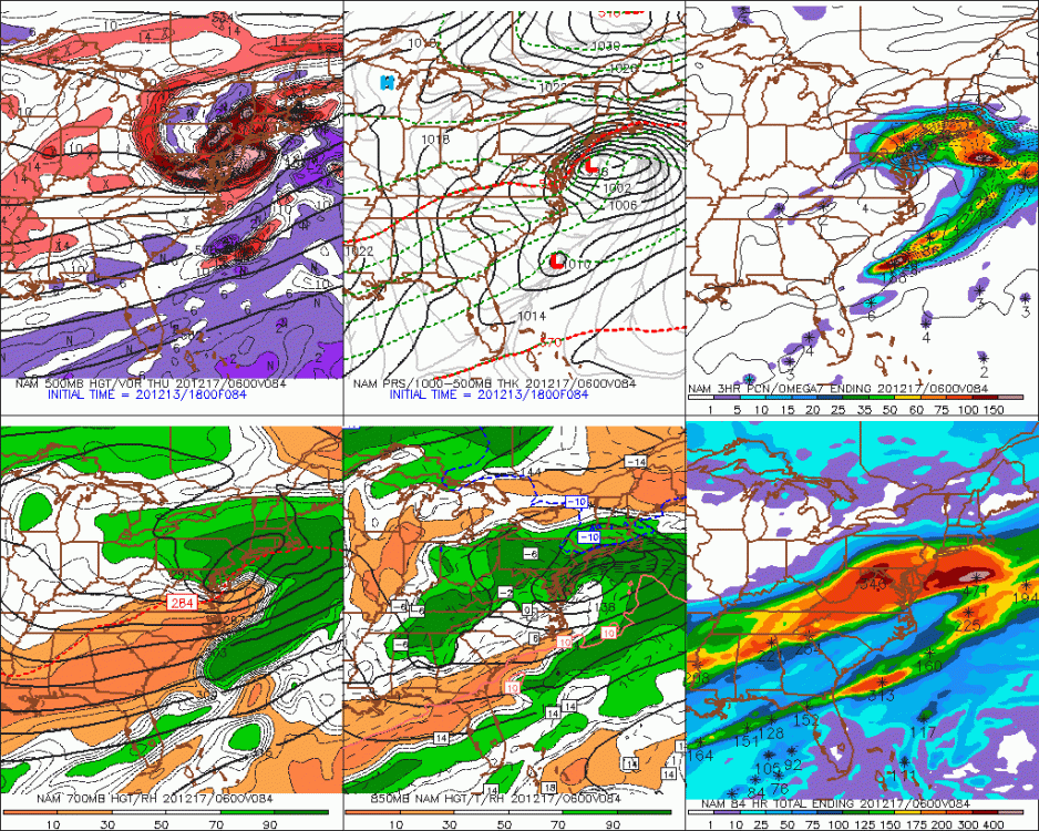
-
Active mid December with multiple event potential
ORH_wxman replied to Typhoon Tip's topic in New England
I remember the euro barfing in that event. Way too suppressed until like 24h out. Rare loss for it inside of 72h up north. GFS wasn’t exactly great either. It was a win for mesos though in that 48h time range. Can’t remember but maybe Ukie was pretty zonked too? But all the models basically whiffed NYC (or have them nuisance snows) when we were at the time range we are now for the current threat. -
Active mid December with multiple event potential
ORH_wxman replied to Typhoon Tip's topic in New England
He’s anticipating a massive capture and retrograde. -
Active mid December with multiple event potential
ORH_wxman replied to Typhoon Tip's topic in New England
I dunno like two other models trended north at 12z. GFS even bumped slightly north even though it is still the furthest south model. Euro trended slightly south. I’m not seeing any sort of golden nugget here by the GFS. -
Active mid December with multiple event potential
ORH_wxman replied to Typhoon Tip's topic in New England
Yeah it was similar but definitely a little bit squeezed compared to 00z. I get that everyone is dying for a huge system, but people need to remember this is like 90-96 hours out still. We’re not even using the NAM/RGEM yet...it feels like this should be about 48 hours out given how long we’ve been tracking it but it still has a long ways to go. Never any guarantees but I still like the idea of bumping a bit north given the deep shortwave associated with this. -
Active mid December with multiple event potential
ORH_wxman replied to Typhoon Tip's topic in New England
EPS not as crazy as 06z (no surprise given the OP was a little south as well)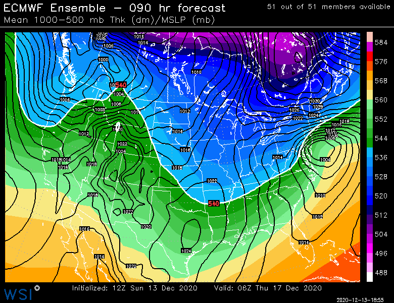
-
Active mid December with multiple event potential
ORH_wxman replied to Typhoon Tip's topic in New England
You are like 5 miles away from getting a death band that run. Lol. -
Active mid December with multiple event potential
ORH_wxman replied to Typhoon Tip's topic in New England
Yes it did. Just wasn’t enough for us. 4 days out it was giving NYC cirrus clouds. -
Active mid December with multiple event potential
ORH_wxman replied to Typhoon Tip's topic in New England
Sure and if it zonks north 100 miles you might be worrying about ptype issues. -
Active mid December with multiple event potential
ORH_wxman replied to Typhoon Tip's topic in New England
He’s just being a massive weenie. -
Active mid December with multiple event potential
ORH_wxman replied to Typhoon Tip's topic in New England
You were pretty close to huge northern weenie band...might have been more like pike region to Rt 2 that run. Negligible at this time range. You’re gonna go insane micro-analyzing each run at 96 hours. -
Active mid December with multiple event potential
ORH_wxman replied to Typhoon Tip's topic in New England
That has a pretty sick banding sig for BOS to ORH on Thursday morning. -
Active mid December with multiple event potential
ORH_wxman replied to Typhoon Tip's topic in New England
The S/w was initially stronger this run but the confluence was a little stronger too, so we ended up with opposing forces with the confluence getting the net victory with a slight nudge south. Tonight is when the main shortwave comes on shore out west so we’ll see if that drastically alters the solutions. -
Active mid December with multiple event potential
ORH_wxman replied to Typhoon Tip's topic in New England
Very similar to 00z. Maybe just a split hair south. -
Active mid December with multiple event potential
ORH_wxman replied to Typhoon Tip's topic in New England
Euro looks a bit less amped than 00z through 78 -
Active mid December with multiple event potential
ORH_wxman replied to Typhoon Tip's topic in New England
Ukie finally more north
-
Active mid December with multiple event potential
ORH_wxman replied to Typhoon Tip's topic in New England
NAM upper air was significantly more amplified at the same hour so I doubt it would have moved the same. -
Active mid December with multiple event potential
ORH_wxman replied to Typhoon Tip's topic in New England
Yeah 00z tonight or 06z once it goes out far enough. -
Active mid December with multiple event potential
ORH_wxman replied to Typhoon Tip's topic in New England
NAM doing NAM things at 84h. Damn that is zonked. -
Active mid December with multiple event potential
ORH_wxman replied to Typhoon Tip's topic in New England
It’s def NW of 00z. Esp at 102 hours near the BM. -
Active mid December with multiple event potential
ORH_wxman replied to Typhoon Tip's topic in New England
Maybe an inch or two on the NAM for Monday in most of SNE. Possibly a little higher down near south coast if they can accumulate efficiently. I’m still pretty skeptical about that threat for much more than a C-1” but not impossible to pick up more if some pretty nice fronto can get going for 3-4 hours. -
Active mid December with multiple event potential
ORH_wxman replied to Typhoon Tip's topic in New England
Uncertainty on GEFS disproportionately to the north side. Id be surprised if it didn’t come north. -
Active mid December with multiple event potential
ORH_wxman replied to Typhoon Tip's topic in New England
102h on EPS
-
Active mid December with multiple event potential
ORH_wxman replied to Typhoon Tip's topic in New England
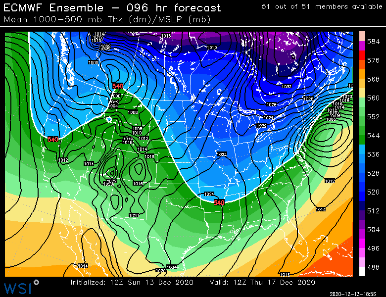
06z EPS are maybe a shade more amped than 00z through 96h
-
Active mid December with multiple event potential
ORH_wxman replied to Typhoon Tip's topic in New England
Euro was an outlier last storm, it is not this time. The GFS suite is now the outlier (except the new parallel which is quite amped).