ORH_wxman
-
Posts
93,092 -
Joined
-
Last visited
Content Type
Profiles
Blogs
Forums
American Weather
Media Demo
Store
Gallery
Everything posted by ORH_wxman
-
Yeah we’ll see. The post-New Years blocking could fail too, though the signal is a lot stronger than this week ever was...so there’s that going for it. But the GFS run definitely shows us how it could fail...we basically get this block 500-1000 miles south of where we originally hoped, lol.
-
Yeah I think we need some warm heavy rains cratering this stuff to really release it quickly.
-
There really is no block. Grinch storm retros to like Baffin Island and we’re left with this weak sauce ridging south of Greenland for like a week afterward....it’s really after the New Years system that the NAO block tries to build in.
-
That has looked almost worse every run imho. I don’t expect anything out of that but there’s still some time for a change in the general synoptic look...but it better start soon.
-
Is that your yard or is your yard more sheltered than that? A sheltered spot with less holes prob has a shot. My yard is full cover right now and expect it will prob survive overnight since the warm rains prob won’t really drench it until tomorrow.
-
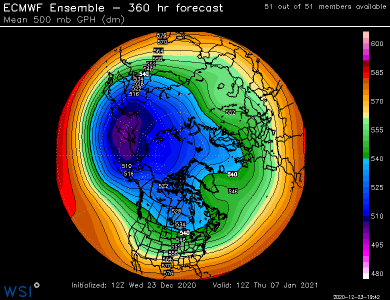
Weeks 2 (1/4-1/11) and 3 look really good. Week 3 actually pops a nice +PNA in conjunction with the -NAO. The weeklies do keep the -NAO all the way into clown range (week 6) but those are hardly worth looking at.
-
That looks like it’s prob toast by tomorrow AM. Too many holes already in the pack on that field.
-
Yeah I’m thinking our pack survives overnight now...it really will release very fast once that warm rain gets into it but we’re gonna have to wait until tomorrow for the heavy rains. Weve actually dropped a few degrees since earlier...peaked at 53F and now back to 48F.
-
For the last couple of days the pattern looks a lot better after New Years. The blocking isn’t really present before that. There was a time where it looked like it may set up a little sooner, but the grinch storm took care of that.
-
Thanks man. Had to dig it out to get it going, lol. But figured why not. Xmas eve and we’re not going anywhere. Might as well enjoy it outside. The Reggae weekend vibe is fun. Too bad it has to downpour tomorrow. A couple days like this would have been totally great.
-
Been an utter dearth of them so far. If this season was acting more like a La Niña we’d see them for sure.
-
You are a very good deeper layer CAD spot (like it will be sleeting in BTV and you could still be all snow)...when it’s really shallow CAD right near the sfc you don’t do as well.
-
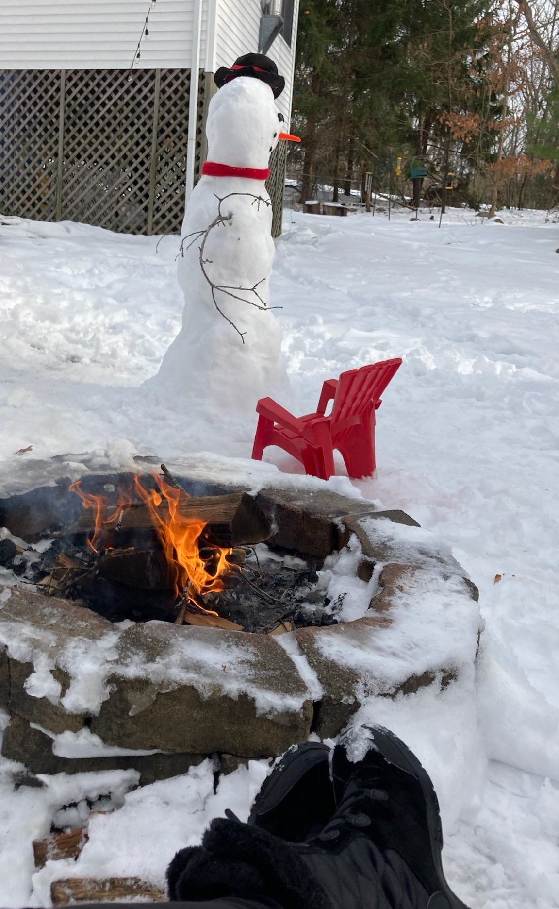
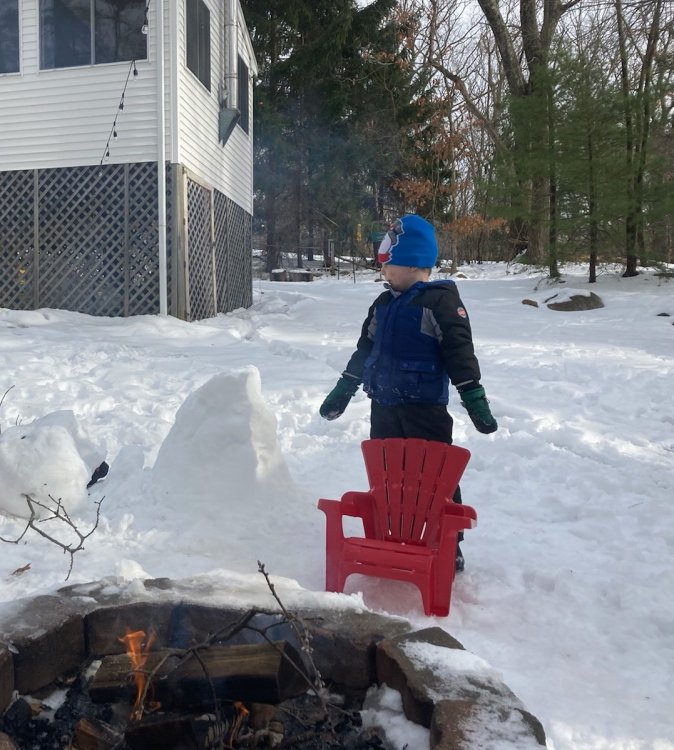
We’re taking advantage of the mild weather. Fire pit going...actually quite the festive Xmas eve with the snow around and mild temps...it almost feels like Reggae week at the ski resort in late March when you have those days near 50 but plenty of corn to make turns on and you sit by the fire pit with a beer afterward. My son built a snowman and then destroyed it 20 minutes later

- 993 replies
-
- 12
-

-
30” is tough for any given one spot. For ORH, there’s 3 such storms on record. If you want to count 1888, that makes 4 (they had 32” in that storm but the official records didn’t begin until 1892 there). BOS has zero 30” storms on record. Though they have come close on a number of them. Parts of SE MA have had several (1978, 2005, 2015). Then you have NE MA where some spots have had a few...Feb ‘69, Dec ‘03 (in a narrow swath), Jan 2015 a little further west toward northern 495 belt. But you’d be hard pressed to find a single point that has more than 3 I’d imagine. Now, there’s definitely no shortage of 20”+ storms in eastern areas. Most places have double digit storms in the 20”+ range.
-
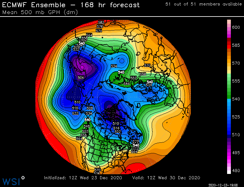
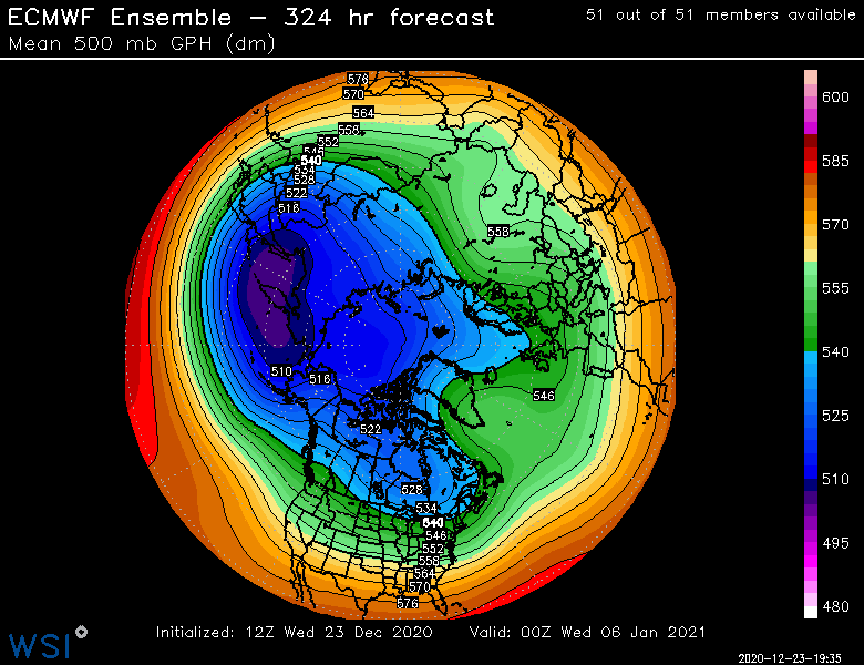
That’s not bad. Good anomalies in the Davis Strait there. If we’re nitpicking, I’d want it slightly more north, but I was more talking about if the blocking was most pronounced in the North Atlantic and closer toward New foundland. Thats also a D16 smoothed ensemble mean so you don’t actually see a “block” there. It just kind of hints at where it might be.
-
Too early to rule out a big winter impact from 1/1 threat, but it’s trending the wrong direction right now. Monster western trough carves out and bides its time while the confluence lifts out. Then it decides to lift northeast perfectly timed for a big cutter. Its possible all that timing will not work out as we get closer and perhaps it ends up more wintry but I’m not overly optimistic at the moment.
-
I’d roll the dice again on Feb 2010. I agree we don’t need something that extreme, but it often works out for us. The one worry I potentially would have is the block won’t set up far enough north. If it sets up a bit south and southwest of Greenland it can actually be a detriment. We want it up into Greenland and Davis Strait. The pacific is progged to be kind of meh in early January so a good NAO block is not a bad thing.
-
All the blocks I listed were uber/crazy blocks. Point is that people should not expect the same outcomes. The 2010 PTSD in here is fascinating.
-
I wonder what y’all would’ve said in Feb ‘69....or Dec 2010/first half of Jan 2011. Or March 2001.
-
Seems like the blocking isn’t really robust until after New Years. It’s around but not going gangbusters until that 1/1 system passes. Btw that trough that is responsible for the 1/1 system looks ridiculous. Where’s the Hadley cell when you need it? Lol, that thing is digging into Cabo SanLucas Even the ensemble mean is pretty aggressive.

-
Yeah there’s never guarantees that far out. But it’s as good as you can really get in the 11-15.
-
I don’t have the index numbers but the hemispheric H5 pattern is about as staunchly pro-blocking in the NAO/AO region as I have seen it at this lead time since the 2010-2011 winter. Hard to get an ensemble mean this bullish out at 12-15 days.
-
Yeah this is one of the worst ones I’ve seen. 1996 was pretty bad though. We had like 8-10” of high content pack leftover from the Dec 6-8 storms wiped out on xmas eve. That one didn’t quite have the winds of this one but I do recall pretty strong winds regardless.
-
GFS would be ok there for 12/29. Foreign guidance is uglier though. We usually know how that movie ends.....lol. The pattern does have some upslope potential at times so I’m sure it will still give snow events for your ‘hood even if the synoptic ones are garbage. It would be nice to get a few synoptic storms to work out though. NNE could use the snow for base building on snow mobile trails and ski resorts.
-
Yeah 3 in a row. 2017 was ridiculous. Like -10 temps lol with a couple small refreshers. Some crappy luck on the evolution of the Xmas storm up north. Ukie was actually the first to show it a few days ago and all other guidance slowly came on board which eliminated 12/29 threat. Now the 1/1 threat looks uglier too but still time to fix that one.