ORH_wxman
-
Posts
93,092 -
Joined
-
Last visited
Content Type
Profiles
Blogs
Forums
American Weather
Media Demo
Store
Gallery
Everything posted by ORH_wxman
-
March 2022 Obs/Disc: In Like a Lamb, Out Like a Butterfly
ORH_wxman replied to 40/70 Benchmark's topic in New England
Wed night/Thu morning is def trending back north. Limiting factor is the weak vort but the vort track itself is pretty good for SNE. If it trends a little stronger then we’re in for a solid advisory event. If it trends weaker then maybe just a few snow showers or even nothing. -
March 2022 Obs/Disc: In Like a Lamb, Out Like a Butterfly
ORH_wxman replied to 40/70 Benchmark's topic in New England
This will be funny to bump when we get another -3 April. -
March 2022 Obs/Disc: In Like a Lamb, Out Like a Butterfly
ORH_wxman replied to 40/70 Benchmark's topic in New England
What April events gave DC to NYC a foot of snow? I’m talking the 95 corridor there, not interior hills. I can’t think of a single one in the last 50 years. April ‘82 got NYC but south of there didn’t get much. You’d prob have to go back to like the famous April 1915 blizzard. -
March 2022 Obs/Disc: In Like a Lamb, Out Like a Butterfly
ORH_wxman replied to 40/70 Benchmark's topic in New England
70F ELM and 71F PEO and 69F at ITH….my old college stomping grounds would be enjoying the faux spring day. -
March 2022 Obs/Disc: In Like a Lamb, Out Like a Butterfly
ORH_wxman replied to 40/70 Benchmark's topic in New England
How often do double digit events to the valley floor out in S MA and N CT happen in very late March or April? It’s prob like a 1 in 30 or 40 year return rate. The only ones I can think of that gave double digits to the valley floor there were April ‘97 and April ‘82. Might have to go all the way back to April 1924 to get the next one. All those post-3/24 events from 1996, 1987, 1984, 1970, 1958, 1956, 1967, etc did not bring widespread double digits to the valley floor there. -
Yep. I filled up last week for 3.40ish and yesterday the same place was almost a dollar more. 4.28.
-
March 2022 Obs/Disc: In Like a Lamb, Out Like a Butterfly
ORH_wxman replied to 40/70 Benchmark's topic in New England
He calls for March 2012 every single year now. -
Yeah there were a couple euro runs that blasted us in eastern areas…I found this Ukie run saved on my phone. Some of the euro runs were similar or even more bullish….it was only for a couple cycles but those cycles happened inside of 48 hours so we had a reason to believe it was trending hard into a big storm but then it trended back east

-
March 2022 Obs/Disc: In Like a Lamb, Out Like a Butterfly
ORH_wxman replied to 40/70 Benchmark's topic in New England
That’s a cutter look. Prob a deep wrapped up storm up in Ontario somewhere with that H5 plot. Behind it around 3/15 is the window I’d be looking at.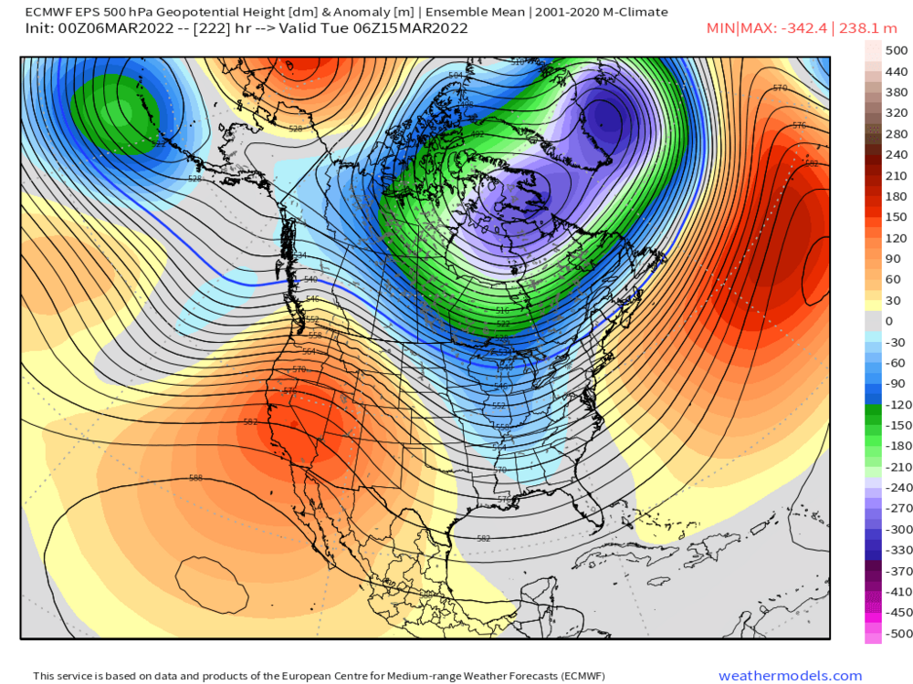
-
March 2022 Obs/Disc: In Like a Lamb, Out Like a Butterfly
ORH_wxman replied to 40/70 Benchmark's topic in New England
There was another storm on 3/12/05 but it was nowhere near a blizzard. Maybe he was thinking of that one. It was actually a storm trying to escape east and dumped a large area of 8-12” over the interior with a bit of an IVT enhancement. -
March 2022 Obs/Disc: In Like a Lamb, Out Like a Butterfly
ORH_wxman replied to 40/70 Benchmark's topic in New England
Nice 3/8/05 redux on the 06z GFS. Euro was a snooze fest though. -
March 2022 Obs/Disc: In Like a Lamb, Out Like a Butterfly
ORH_wxman replied to 40/70 Benchmark's topic in New England
We had a high of like 25F in full sun with zero pack in April during that cold outbreak. It’s really hard to beat that. It was brutally windy too. The only max temps on record colder than that in ORH were on snowy days or days with fresh snow cover. -
March 2022 Obs/Disc: In Like a Lamb, Out Like a Butterfly
ORH_wxman replied to 40/70 Benchmark's topic in New England
Yea I remember that. It missed us south. 4/8/95 I think. It was after that ridiculous cold outbreak we got on 4/5 and 4/6 -
March 2022 Obs/Disc: In Like a Lamb, Out Like a Butterfly
ORH_wxman replied to 40/70 Benchmark's topic in New England
Jesus. I can see some grass blades already poking up. That’s pretty terrible. -
March 2022 Obs/Disc: In Like a Lamb, Out Like a Butterfly
ORH_wxman replied to 40/70 Benchmark's topic in New England
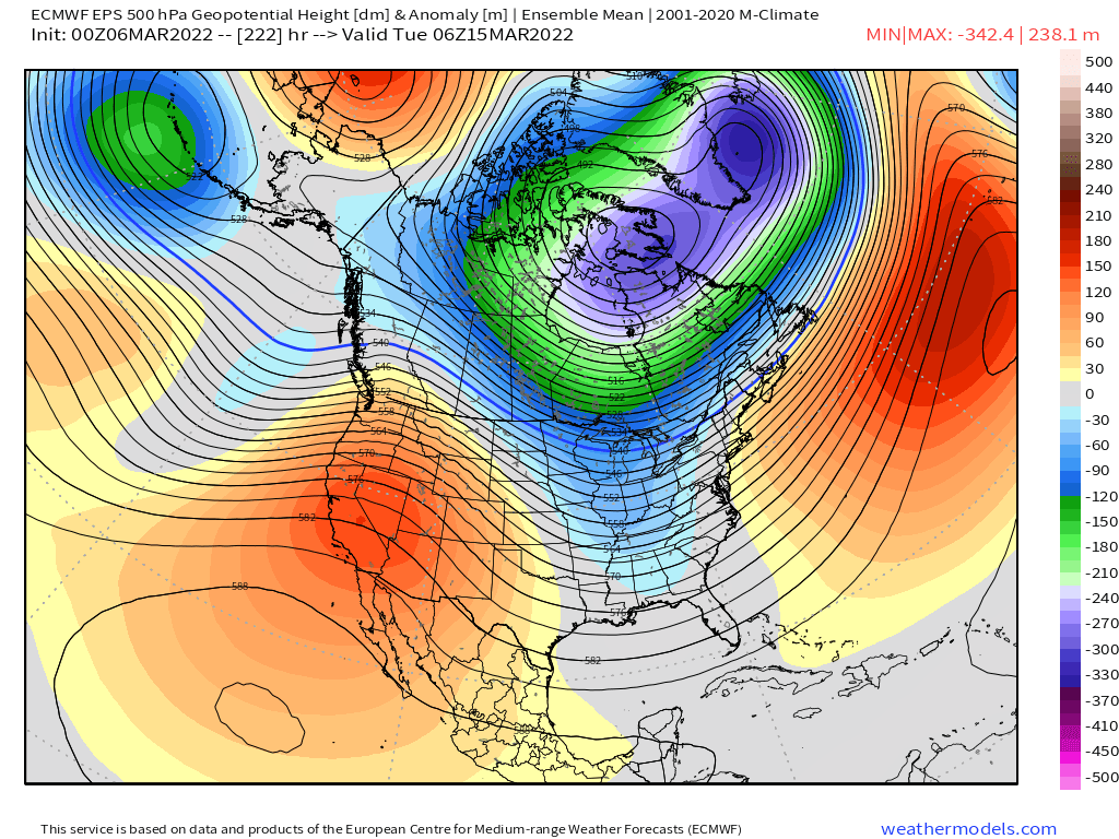
EPO kind of retrogrades back northwest a bit whereas on guidance earlier this week it was folding the block over eastward into a PNA burst….so I agree the pristine look has degraded. There’s still a western ridge spike but it’s not shooting up into NW territories now….it’s more constrained to the CONUS and maybe southern BC. That’s still enough for a potential system but it requires more shortwave cooperation than those rare synoptic beasts that are almost predestined to happen when you get long waves syncing up. -
March 2022 Obs/Disc: In Like a Lamb, Out Like a Butterfly
ORH_wxman replied to 40/70 Benchmark's topic in New England
His front yard gets torched. -
March 2022 Obs/Disc: In Like a Lamb, Out Like a Butterfly
ORH_wxman replied to 40/70 Benchmark's topic in New England
I highly doubt it’s the last snow. I can think of only one year where our last snowfall of more than an inch was in February. 1994-1995. Even 2011-12 had a front ender in March that dropped several inches. Might have screwed your area though…can’t quite remember. -
March 2022 Obs/Disc: In Like a Lamb, Out Like a Butterfly
ORH_wxman replied to 40/70 Benchmark's topic in New England
Coastal. (Assuming you’re referring to the mid-month Euro system) -
March 2022 Obs/Disc: In Like a Lamb, Out Like a Butterfly
ORH_wxman replied to 40/70 Benchmark's topic in New England
A lot of people who like cruisers don’t ski trees. I love trees usually but there are days I don’t want to deal with them or if my legs are shot after a bunch of tough runs, I’ll want to relax on some cruisers. -
March 2022 Obs/Disc: In Like a Lamb, Out Like a Butterfly
ORH_wxman replied to 40/70 Benchmark's topic in New England
Euro cooking up a nice system mid-month. That’s the window for another system. GGEM and Ukie try for something before that but I’m tossing those. -
March 2022 Obs/Disc: In Like a Lamb, Out Like a Butterfly
ORH_wxman replied to 40/70 Benchmark's topic in New England
We had some really good Marches since the big 2013 March….2017, 2018, and 2019 were all big (2014 in NNE was huge…we got boned down here except for the Cape peeps in the 3/26/14 blizzard and 2015 was big on the south coast) I guess we were due for a couple March clunkers in a row. Hopefully this one can start producing. -
March 2022 Obs/Disc: In Like a Lamb, Out Like a Butterfly
ORH_wxman replied to 40/70 Benchmark's topic in New England
We’ll see. Right now there’s no threats for NNE and the 3/12 system looks cutter-ish. Can still change though. A couple high-QPF snowers for NNE mid-month would really help. -
March 2022 Obs/Disc: In Like a Lamb, Out Like a Butterfly
ORH_wxman replied to 40/70 Benchmark's topic in New England
Sucks up there in March…that’s supposed be prime skiing time in NNE. Maybe 60 is ok on reggaefest weekend at the end of March if it’s sunny/dry with the slopes covered in feet of snow. NNE has been pretty unlucky the past couple Marches and this one isn’t starting good either. I would’ve figured they’d do well with the look the past week and upcoming week but it hasn’t really happened. Phin’s area is probably due for one of those 50-60 inch months in March. -
The Mar 2, 2019 storm was kind of disappointing in that for a couple runs it was absolutely crushing E MA/RI. We’re talking like a foot of snow…it ended up weaker and south so it was just an advisory type event in the end….but that would have been something to get back to back 12”+ storms 2 days apart.
-
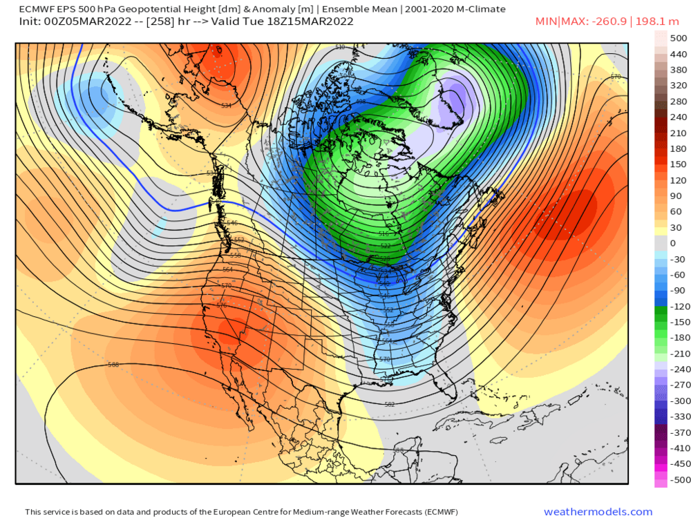
March 2022 Obs/Disc: In Like a Lamb, Out Like a Butterfly
ORH_wxman replied to 40/70 Benchmark's topic in New England
I’d look at two periods…first one is maybe 3/11 where a front running wave tries to get us. Not super excited about that one but it’s been on and off guidance for a few cycles now. The better window is prob like 3/14-3/17. There’s a western ridge that spikes a bit around then (see below EPS)….no guarantees for anything but that is synoptically the best window if we have one more good one in us