ORH_wxman
-
Posts
93,095 -
Joined
-
Last visited
Content Type
Profiles
Blogs
Forums
American Weather
Media Demo
Store
Gallery
Everything posted by ORH_wxman
-
Euro def gonna be north of 06z
-
Yeah once inside of 24h, they usually get most of the weight. Euro has had its share of duds inside of 24h this season.
-
GFS/Euro are going to get like 90% of the weight in a 3 day forecast....prob reduced to like 60-70% inside of 48h where NAM and other mesos can pick up some of the slack.
-
This would be a full-on cutter if it weren't for the -NAO....but at some point you reach an equilibrium which is where we are close to now...so we see these wobbles....colder, warmer, colder, warmer has been the trend the last 3 or 4 cycles.
-
None of these solutions synoptically are drastically different, but as Tip said, these really mild nuances can have large impacts on sensible wx.
-
Further east track on the shortwave will produce big QPF....wrapping it up west ala NAM will keep is fairly paltry by comparison...that's basically the larger scale view of how QPF will trend in this.
-
This run actually has a better CCB Saturday morning than 06z did for SNE, despite the initial thump being a bit north.
-
Confluence was def initially stronger, but the main shortwave looks like it's gaining just a smidge more latitude by 60h.
-
GFS actually looks stronger with the confluence through 36h than 06z did. We'll see if that holds.
-
We'll see what the real models do soon. JV hour basically was a wash.
-
Actually looked a lot like the GFS that run.
-
Icon actually ticked colder.
-
Almost no change though...it was like a 10 mile shift....nothing like the NAM. Hopefully NAM is off its rocker.
-
Yeah initially the S/w was weaker which kept downstream heights lower, but then it drifted north at a further west latitude than the prior run after about 57 hours...and that's the key. Those further west solutions just don't give us the good front end thump. Sent the goods into upstate NY again.
-
Eh, now it looks warmer at 63 hours...lol
-
It's coming in colder anyway despite the slightly weaker confluence because of the other two factors I mentioned....weaker shortwave and less WC troughing pushing up heights downstream.
-
Confluence looks just a tick weaker on the NAM through 48h, but the main shortwave is also weaker and the western trough is shallower, so not sure how this one will play out.
-
I'm not all that comfortable yet along the pike....I'd prob want to see one more shift S by at least the non-GFS guidance. I'm always nervous about little north ticks inside 48. The one factor that may help in this is the block is in the process of retrograding/strengthening, so I do like that mode of change occurring which was also present in yesterday's event which helped shove it into a CT special. That event never really came back north...it sort of tried to at the last second but only did so marginally.
-
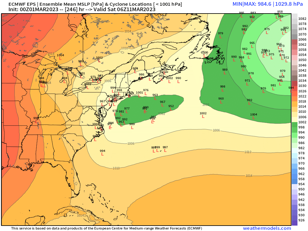
EPS is honking....GEFS coming around, but a little less robust on the signal. GEFS is also more like 3/13ish rather than 3/11 on the EPS Anyways. here's the EPS....quite a signal for 10 days out.

-
It's because the GFS isn't really showing a SWFE...it's almost morphed into a Miller B with closed mid-level circulations going south of us.
-
06z EPS made a nice little tick south too.
-
06z euro a little colder again. Baby steps.
-
GFS solution is getting close to a Miller B. Getting closed circulations in the midlevels
-
Yep. Nice bent back WF too on the front end there. That’s the kind of look you want. It’ll rip just north of it.
-
GFS looks like it may come in colder than 18z