ORH_wxman
-
Posts
93,095 -
Joined
-
Last visited
Content Type
Profiles
Blogs
Forums
American Weather
Media Demo
Store
Gallery
Everything posted by ORH_wxman
-
Feb 28th-March 1st long duration Miller B threat
ORH_wxman replied to George001's topic in New England
ORH hills are gonna do well with the IVT stuff. It’ll prob be just cold enough there with the elevation to accumulate during the day. Prob the kind of thing where there’s a pretty big difference between 700-800 feet and 200 feet. -
Feb 28th-March 1st long duration Miller B threat
ORH_wxman replied to George001's topic in New England
Wow that is a pretty good run from HREF. I think it was a couple winters ago it did really well. During some of those February storms. Seems like most runs are coming in a bit more uniform tonight. Best is still CT to W MA but we’re getting a little more QPF thrown to us out east. -
Feb 28th-March 1st long duration Miller B threat
ORH_wxman replied to George001's topic in New England
IVT is prob gonna be elevation dependent on accumulations. -
Feb 28th-March 1st long duration Miller B threat
ORH_wxman replied to George001's topic in New England
Yeah i certainly wouldn’t be forecasting NAM amounts here right now. It’s been the northern outlier since yesterday. It’s nice that it bumped north a little though instead of coming back toward consensus. RGEM is coming in now and not providing any support really. It did bump north but only marginally. It’s been consistently in the opposite spectrum as the furthest south model. -
Feb 28th-March 1st long duration Miller B threat
ORH_wxman replied to George001's topic in New England
I don’t think it looks that pasty until during the day on Tuesday. Soundings are keeping sfc temps in the upper 20s across most of CT during the best snows Monday night/predawn Tues. The south coast may be the exception where sfc temps creep closer to freezing. -
Feb 28th-March 1st long duration Miller B threat
ORH_wxman replied to George001's topic in New England
Nice look along the pike with that northern band. -
Feb 28th-March 1st long duration Miller B threat
ORH_wxman replied to George001's topic in New England
HRRR was pretty tasty…but clown range HRRR isn’t very reliable. Take with grain of salt. But I’d rather see it amped than not. -
Feb 28th-March 1st long duration Miller B threat
ORH_wxman replied to George001's topic in New England
Honestly on the fence here. I’d feel a lot better if I was a little further west. I’d prob put the O/U at 3” here. But it wouldn’t take much to get warning amounts if we can hold that shortwave together just a smidge longer. -
Feb 28th-March 1st long duration Miller B threat
ORH_wxman replied to George001's topic in New England
The block in this one is pretty set. It’s really all about the shortwave intensity now. The models that eject it out a bit stronger which allows it to hold together longer will produce more robust snow totals while the weaker ones will not. -
Feb 28th-March 1st long duration Miller B threat
ORH_wxman replied to George001's topic in New England
RGEM didn’t really improve from 18z. Maybe a bit over SE areas. But overall still fairly paltry. -
Feb 28th-March 1st long duration Miller B threat
ORH_wxman replied to George001's topic in New England
It was able to curl up some of that WCB too which took the precip hole away from SE MA and actually gave them part of the bigger snows…RI gets hammered that run too. That’s the key though…keep that shortwave just strong enough to curl in that moisture thump and have it run into that stout high…good fronto. -
Feb 28th-March 1st long duration Miller B threat
ORH_wxman replied to George001's topic in New England
The difference was we got a little more vigorous shortwave ejection. The block didn’t look like it got any weaker this run. -
Feb 28th-March 1st long duration Miller B threat
ORH_wxman replied to George001's topic in New England
That was a decent bump on 00z NAM. CT really gets pounded but even pike region is prob low end warning snow there. -

-
Wow those are gorgeous pics subdude. They look great with the fresh snow too.
-
Really nice outline John…thanks for the start on this thread. Im going to ask people to keep this thread cleaner than the last one. Keep the discussion on topic. There’s going to be highs and lows on the model guidance, but stick to the meteorology. We have a banter thread too if peeps need to sound off (and a panic thread too).
-
Feb 28th-March 1st long duration Miller B threat
ORH_wxman replied to George001's topic in New England
Might be the heaviest snow I’ve ever seen. My aunt used to live right up near Alpine Meadows ski resort so we’d go there sometimes. Feb 1994 (ironically during the brief thaw in the east that winter) when I was on school vacation we went and there was a storm that dropped about 6-7 feet in 3 days but one of the days must have snowed 4 feet and during the peak of it I’m guessing it was like 7-8 inches per hour. Might have been slightly more even….it was actually kind of scary being out in it because you couldn’t see anything. Vis was maybe 25 feet? This was well before normal people had cellphones so you could actually wander 20 yards in the wrong direction and have no way to get back or call for help. -
Feb 28th-March 1st long duration Miller B threat
ORH_wxman replied to George001's topic in New England
18z euro still ka-ka for us easterners. It actually looked a bit better than 12z for the CT crew. -
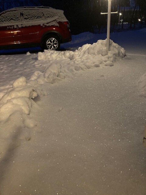
This stuff is jspin blower fluff. Tried to get all the sparkling in the pic
-
Feb 28th-March 1st long duration Miller B threat
ORH_wxman replied to George001's topic in New England
Yep. Can’t even let the CT folks go 5 posts to enjoy the lead-up to this without the 15th time telling us how shitty the system looks for eastern MA -
Feb 28th-March 1st long duration Miller B threat
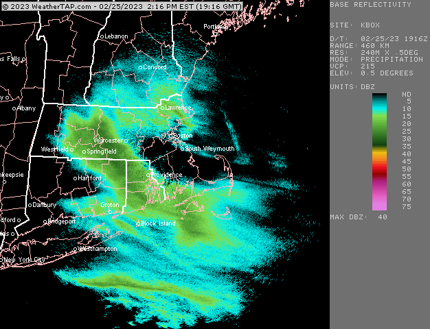
ORH_wxman replied to George001's topic in New England

-
Just getting into this band. Snow has commenced and vis dropping quickly
-
Feb 28th-March 1st long duration Miller B threat
ORH_wxman replied to George001's topic in New England
LOL. Brings back Feb ‘89 PTSD for me. At least we still got 4 inches of sand in that one. But oh man, same exact vibe. Snow started way late in that one and it ended up being a cape crusher. -
Individuals

-
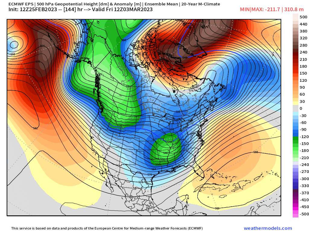
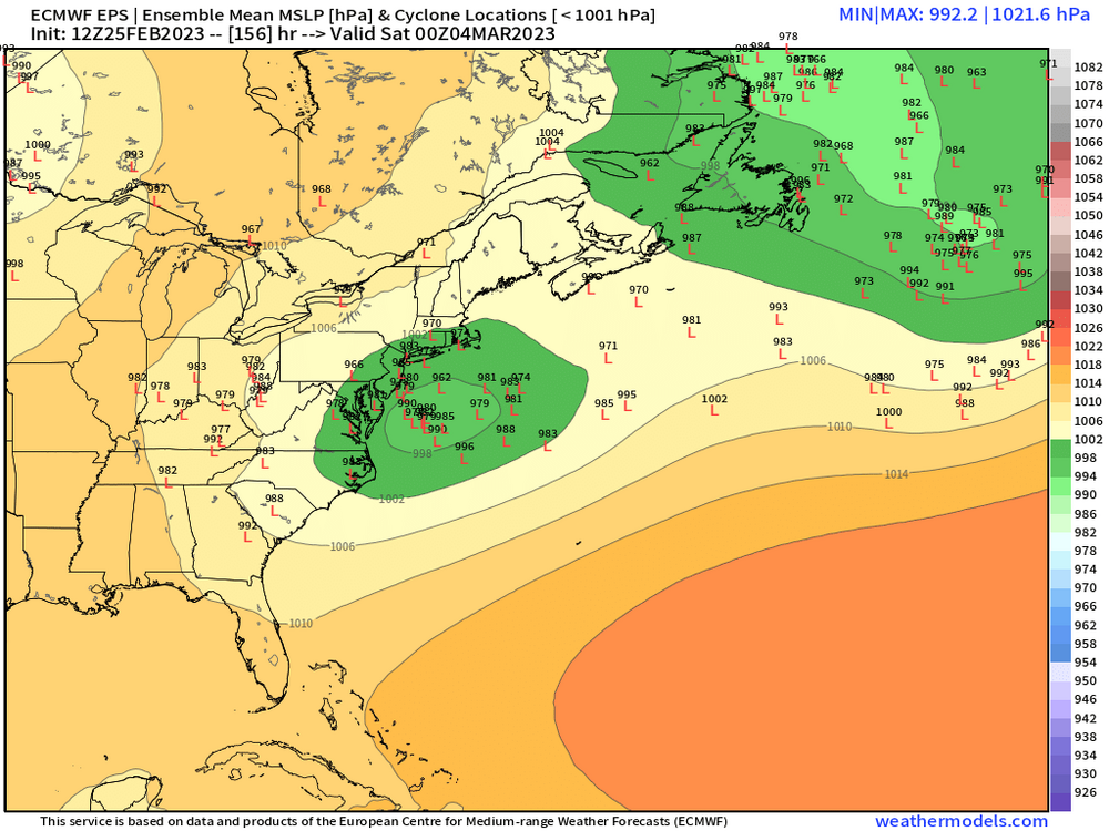
I agree this synoptic setup is not a ridge linking up…there’s a clear 50/50 signal in between the positive height anomalies. Here’s 144h right as the storm is gearing up to form..the SE ridge offshore (more like a WAR there) puts my suppression concerns lower on the list…so I agree with scooter that this doesn’t really look like a whiff storm. I’d be more worried about ptype