ORH_wxman
-
Posts
93,082 -
Joined
-
Last visited
Content Type
Profiles
Blogs
Forums
American Weather
Media Demo
Store
Gallery
Everything posted by ORH_wxman
-
Octorcher or Roctober 2023 Discussion Thread
ORH_wxman replied to Damage In Tolland's topic in New England
Been a while since we had consistent N PAC look like that with the decent western ridge. I expect just a cold shot out of the general longwave look, but we obviously know that snow can happen that time of the year even if not all that frequently.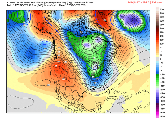
-
Yes agreed....it's why so many here often hear us say "the cold may initially dump into the plains/rockies but could ooze over the top before we get more established cold X days later".....when the cold leaks over the top before the motherload later on, that's frequently an opportunity for an overrunning/gradient type event....
-
Octorcher or Roctober 2023 Discussion Thread
ORH_wxman replied to Damage In Tolland's topic in New England
Does it count as a town if nobody lives there? 510 thicknesses would be extremely impressive for first few days of November....doubt it's that extreme, but there's pretty good ensemble support of a decent cold shot as of now. Would be good to kill off the rest of the yellowjackets at least. -
Octorcher or Roctober 2023 Discussion Thread
ORH_wxman replied to Damage In Tolland's topic in New England
What town? Dude lives in the middle of nowhere, lol. -
Octorcher or Roctober 2023 Discussion Thread
ORH_wxman replied to Damage In Tolland's topic in New England
Men in thy knickers screaming about a volatile climate.... -
Octorcher or Roctober 2023 Discussion Thread
ORH_wxman replied to Damage In Tolland's topic in New England
I love how they flirted with 0F on 11/5 and then hit 72F 10 days later. -
Octorcher or Roctober 2023 Discussion Thread
ORH_wxman replied to Damage In Tolland's topic in New England
Yeah there's definitely a weakness in the snowfall that shows up on the daily records for ORH (and by extension that would include most other interior SNE sites) in early November....really the first 5 days of the month...and late October has a lot of days that beat those first 5 November days.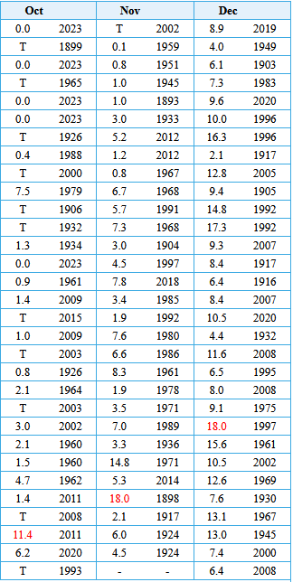
-
It's a fairly common pattern when you get a -EPO block that kind of folds over....but the placement of these features would probably be a bit different int he winter with extended wavelengths. We'd prob see more of an Aleutian ridge poking into AK from further west than we see here to get that negative height response in the PAC NW. If you had an Aleutian low with a -EPO in winter, all of that response to the east would look different than it does here in October. You prob have the lower height response occur much further east. This is all speculative anyway. Who knows what the N PAC will look like in winter...but I'd be surprised if we got a lot of -PNA patterns this winter. I'd expect -PNA patterns with this strength of El Nino to be transitory.
-
There's a vortex over the Davis Strait though....that's the opposite of the December blocking episode last year. There's also a weak Aleutian low in the N PAC....opposite of the ridge last year. Longer wavelengths in winter prob is a lot colder look
-
Octorcher or Roctober 2023 Discussion Thread
ORH_wxman replied to Damage In Tolland's topic in New England
Narrowly missed snow in 2014....I think that was the day Blue Hill got a couple inches but west of Rt 128 didn't get much of anything. -
The Modoki index just tells you how west or east based the ENSO event is....so they are calling for a Modoki index of +0.4 which is a somewhat neutral number....basically basin-wide.
-
It will also be interesting to see how the pattern actually sets up versus the sensible wx results....95-99% of the population will only care about the sensible wx results, but I'll definitely be interested in how we got there. For example, what if we torch this winter but it's because of a La Nina-ish -PNA pattern in tandem with a +AO/NAO (think 2011-12).....a lot of the Super Nino fetishists will start screaming "seeee!!!11!! told ya it would be a torch!!11!" but the irony would be that it wasn't for remotely the reasons they were expecting.
-
Yeah I've often had a hard time going against the PTSD tide of -PNAs in this forum....really since I've been on the forum. Every time I think people will stop being so scared of them (take the 2007-08 through 2010-11 winters for example.....or 2016-17, 2017-18), we then get a horrific one that sends everyone back to their priors about -PNAs. But I think most of it comes from a caricature of what a -PNA is....when people think of a -PNA, they mostly envision that longwave trough in December 2022 that dug so far deep that it turned the Rose Bowl into a winter wonderland while screwing us out of an otherwise decent chance for something ourselves. Further south it's fair to be more afraid of them, but it's mostly silly in New England. Obviously we don't want anything too extreme like the example above, but we can live with -PNA patterns....our correlation to temps on the PNA is actually pretty weak here. Now all else equal, would I prefer a +PNA? Yeah probably....but it's not near the top of my list.
-
Octorcher or Roctober 2023 Discussion Thread
ORH_wxman replied to Damage In Tolland's topic in New England
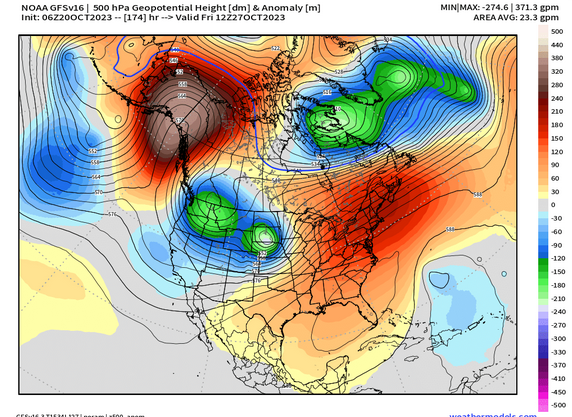
Not with a high sitting over the Andrea Gail. But it does look like a good cold shot just before Halloween, so some sort of marginal snow event isn't impossible. It's a semi-common time to see some sort of first snow in New England...usually interior and further north, but obviously it can happen over SNE too occasionally. Hell, just 3 years ago was a pretty robust event. -
Octorcher or Roctober 2023 Discussion Thread
ORH_wxman replied to Damage In Tolland's topic in New England
Yeah same here too...we popped a bit more in the past 3-4 days and while I'd still classify it as a below average foliage year, it's not like a bottom 5 which is what it was starting to look like a week or two ago. -

-
Yeah...I mean I'm definitely leery of the strength of the El Nino causing us problems in the snow department, but I am not hugging Super Nino climo at this point for 3 main reasons: 1. We're not even sure this will qualify as a Super Nino (looking increasingly like it might fall short) 2. Our sample in Super Ninos is very small 3. Even if it does technically qualify as a Super Nino, will the warming in the western PAC regions affect it's behavior. (e.g. MEI looks much weaker than a typical Super Nino, and this suggests that the atmosphere may not behave like a typical Super event) The key will be monitoring the strength of the Aleutian low and it's placement....in the typical blowtorch Super Ninos, the Aleutian low set up more in the GOA (Gulf of Alaska) rather than further west south of the Aleutians and it was much bigger/stronger than other El Nino events. Becuase of this, you just see this firehose of Pacific air slamming into the CONUS and not allowing much cross-polar flow or even domestic cold from AK/NW Canada to become the dominant source of our airmasses.
-
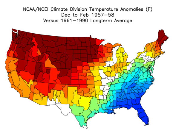
'65-'66 was much colder in the plains and west than '57-'58 was, but yeah, it's not a terrible match east of the MS River. Above average from Great Lakes to New England but below average from about DC southward. It was a decent snow winter for SNE on the whole, but not a great one. Slightly above average for most places here....maybe more like near average for PVD/far southeast areas.
-
And I'll add that "Soft -PNA" periods could still be very productive for snow if we're getting a favorable arctic. What I mean by "Soft" is that it's not a ridiculous longwave trough swinging down into Baja Cali dusting the Hollywood sign with snow. Usually just some weakness in the western ridge or a shallow trough over the PAC NW....something we've seen a bunch of times before during cold/snowy periods as long as the arctic was cooperating. I'd expect plenty of troughs to swing through the southwest this winter, but probably more due to split flow (with STJ going strong) and not because the polar jet stream was making a surgical strike from Barrow, AK to Palm Springs.
-
I'd be shocked if we don't have many solid +PNA periods. I don't expect a standing wave +PNA ridge like we had for 8+ weeks in late Jan-Mar 2015, but this El Nino is too strong not to force some decent Aleutian Low/+PNA periods. Whether they are fruitful will probably come down to how hostile the arctic is or not....if we get a shit arctic (esp near the EPO region), then it's probably just another flavor of dsogshit....but a half-decent arctic would probably produce some real fun periods.
-
It's kind of a '57-'58-esque temp pattern...and that was a big interior winter. Coast did ok too, but the real goods were interior.
-
Yeah over the interior of SNE, '95-96 is still #1. In fact, in ORH, '14-'15 isn't even #2, it narrowly loses to '92-'93. Regardless, if we can get some good periods of +PNA mixed with a favorable polar domain, then we should have plenty of chances this winter. Hell, even a -PNA/-AO would be ok provided we're not first digging the PNA trough into S CA and Baja first before it swings eastward like December last year.
-
Yeah I loved the old hour/storm total/snow depth obs at the end of the METARs
-
Yeah the coast got decent snow on the front end of that post-Xmas storm....it just got matted down with a lot of rain when it flipped while it stayed snow around 128 and west. But that's still a good December on the coast.
-
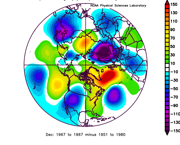
Doesn't look quite as bad as some other recycled garbage patterns because you have a pretty strong ridge poking up to the GOA....so even though the EPO isn't strongly negative, you have cross polar flow at least coming from Bering/AK region rather than the source region being the Pacific. The pattern actually looks really similar to Dec 1967...that month was near normal temps, maybe slightly above (in the 1967 context with '51-'80 normals)....but it had some decent snow chances, although you'd probably take a toaster bath in the 12/28/67 storm which was a classic Rt 128 storm where BOS and the south shore struggled while metrowest cleaned up.