ORH_wxman
-
Posts
93,099 -
Joined
-
Last visited
Content Type
Profiles
Blogs
Forums
American Weather
Media Demo
Store
Gallery
Everything posted by ORH_wxman
-
‘09 and ‘02 weren’t. But yeah it wouldn’t be surprising. They do start to look good closer to Xmas week but obviously anything beyond about 3 weeks is like throwing darts
-
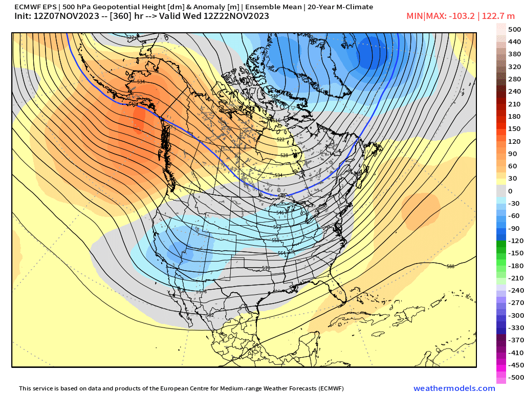
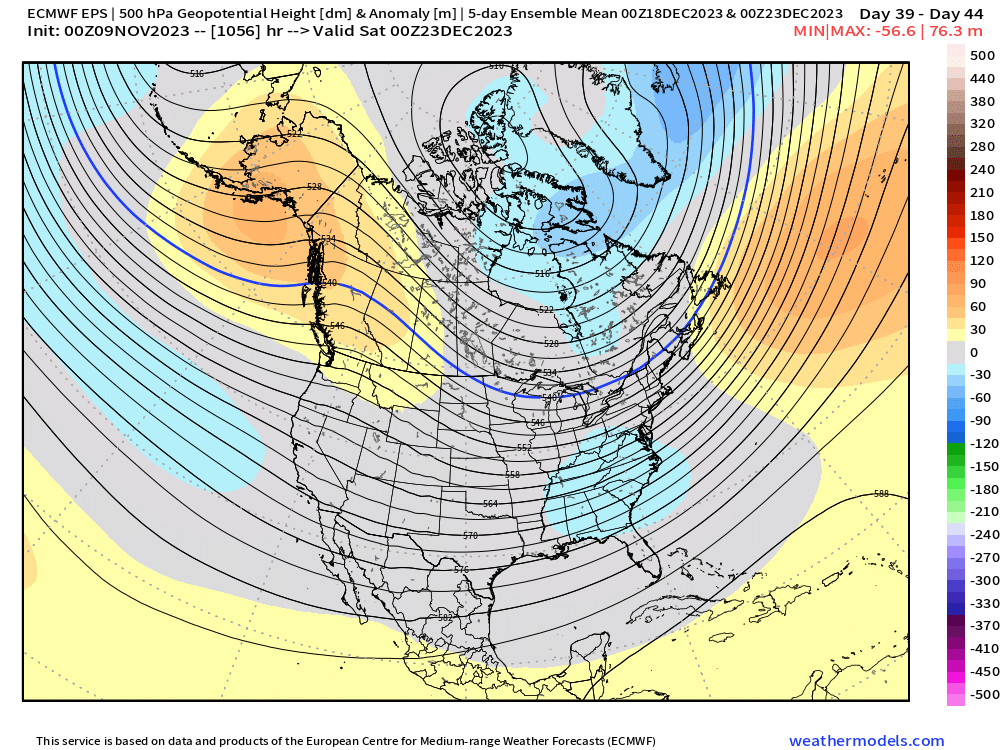
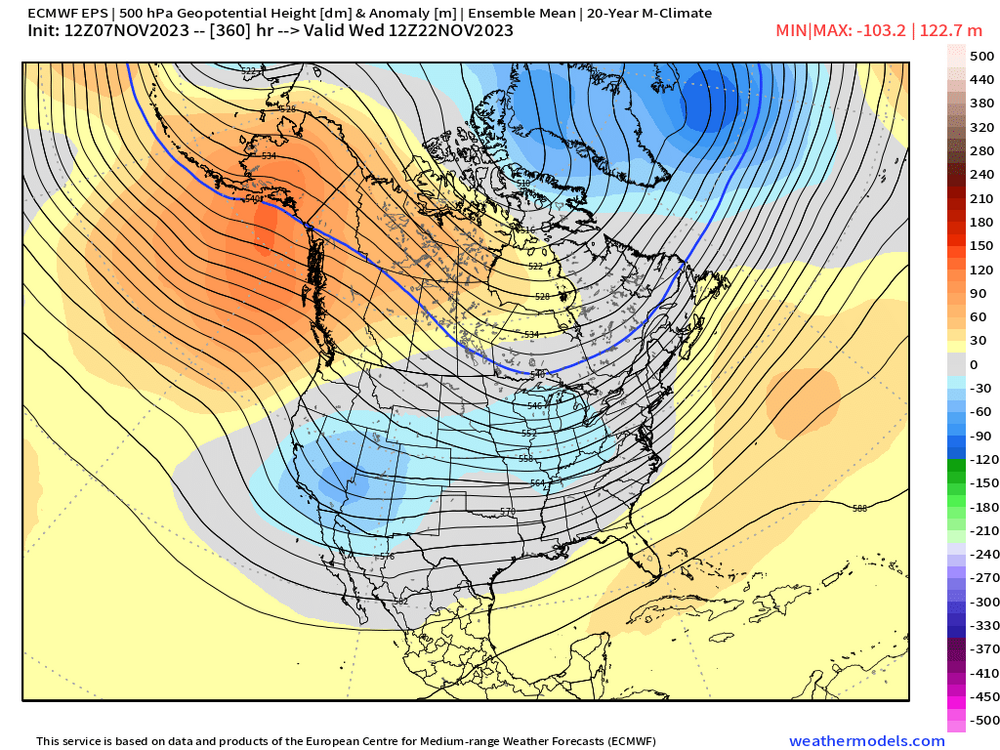
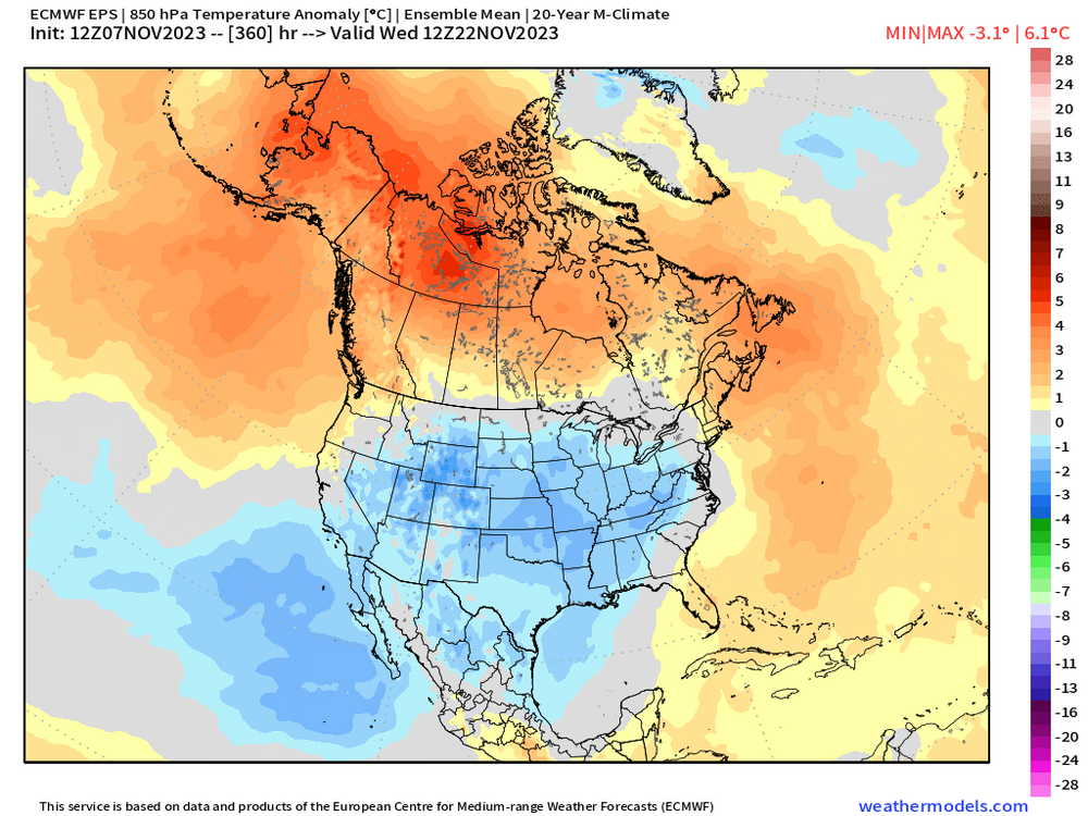
Euro weeklies today:


-
First Thanksgiving was mild....you gotta wonder if the Pilgrams were throwing their crates and wagons against the rocks in anger.
-
It was also T-day week that started this discussion. The warmup around 11/15-16 has been pretty well-advertised for over a week now. What happens after about 11/20 is the bigger question.
-
Been a model war of sorts of Tday week....GEFS have been colder the last few runs while EPS are slightly above normal.
-
Does CPC use 2N to 2S as the upper equatorial OHC latitude domain? I know some datasets use 5N to 5S, so if they are different, then they wouldn't be comparing the same thing.
-
Need to get another snowstorm at the Rose Bowl.
-
35F and maybe a little drizzle here. November is often a horrible weather month.
-
It's mostly the lack of OHC in the upper subsurface (bluewave has been showing this too for many weeks)....compared to other Super Ninos, this event is seriously lagging in that department....which is why every time we've seen all this hype about another WWB or kelvin wave, the SSTA response has been tepid at best. This evetn will probably warm a bit more, but getting very hard to see path for enough warming to qualify as a Super Nino on ONI.
-
These recent GFS runs have had some awesome looks in clown range. Hopefully we can get something to setup resembling that. Still some differences between EPS and GEFS for that period but they aren’t horribly far off.
-
Next Monday night/Tuesday might be a good appetizer for winter in the upslope spots in NNE. Im expecting currier and Ives photos…hopefully Stowe hasn’t turned on the pavement melters yet.
-
Looks cold for the south but not particularly cold for northern tier…esp N plains. Northeast might be near normal in that type of look which would be good enough to produce some good snow threats when you have an active STJ. But often, the devil’s in the details. If the positive height anomalies in Canada are pushed a little further north, then it quickly becomes a colder look for the northern tier….and likewise, if pushed south, it becomes a warmer look for everyone.
-
The bolded has been said a bunch during our cold Novembers. “The pattern is going to flip to warm once winter starts” was the most popular. Honestly, I’ve seen both happen where the pattern locks in during November for many weeks well into winter and other times where it flips.
-
Agreed. Typical wavelengths aren’t really in place yet for winter…and I think this year especially, we need to be wary of the potent El Niño still developing which can cause drastic changes in sensible wx as winter matures. It’s easier to start feeling down on winter in La Niña if December is a turd, but that’s probably premature in a potent El Niño. On the flip side, if we start rocking with snow threats in December during potent El Niño, that’s usually a sign of good things to come.
-
There’s been a lot of uncertainty out in that D10-15 range. Going full-on split flow out west is going to cause a colder look if that’s the path we take (ala OP GFS)…but EPS/Euro guidance has been saying not so fast…wait another week for that to happen. Interesting to track though…
-
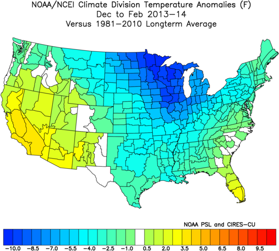
It was cold here but the winter was FAR more severe in the Lakes/Midwest/upper plains.
-
Yeah Jan-Mar is rocking in that but even December was decent…not as cold as the other months but that would likely produce some real winter threats. None of this really matters though…I wouldn’t trust those LR model runs as far as I can throw the supercomputer that runs them.
-
Surprised how good December looks on that.
-
OHC being so weak compared to other Super Ninos seems to be a big culprit on why these westerly wind bursts aren’t producing big spikes in the SST anomalies. Good to see it rising a bit now as that should help with Chuck’s +PNA indicator…and I think we want to see some more 3.4 warming so this acts a bit more Nino-ish as we go into January. But having this Nino behave much weaker is probably not necessarily a bad thing as we go into December.
-
If MEI has trouble getting above 1.0, then it could be a big deal. I still expect it to but that was prob the nail in the coffin for anything above 1.5 (it was already looking dubious for that anyway before the update)
-
Yeah I think some spots down there had over a foot. I had about 6.5-7” in ORH for that one. We never got into very strong banding but just a consistent moderate snow all night…really good storm for that early in the year.
-
Yes…could be a smaller type exotic animal farm too…or someone owning them as pets illegally (actually relatively common). This scenario is really unlikely any time soon though because the females rarely wander too far from their mother’s home range. Males OTOH will wander quite a bit further in search of their own territory. We’d prob need to see a breeding population within a couple hundred miles for it to be realistic. Most likely scenario is public support for a reintroduction program increases enough that it happens. They’ve had studies on it and estimate it would prob save 100-200 lives over a decade because of so many fewer deer collisions on the road…where would far outweigh any rogue cougar attack (it would be surprising to get more than a couple in a decade for a reintroduction program in New England). But we’re still prob a ways off some serious discussion.
-
Cold weekend and early next week…then potential torch for late next week/weekend…perhaps Tday timeframe and beyond looking a bit more wintry? EPS seems to continue to advertise the flip…we’ll see if it gets pushed back or not in the coming days
-
I used to be fascinated by this stuff (still am but less time these days to research it)….and the overwhelming majority of cougar sightings are just mistaken identity. A lot of times it’s just a large Bobcat where the tail may appear to be longer from a certain angle. But yeah, there are occasional confirmed sightings. Most of which are escaped captives in New England. In Massachusetts there have only been two confirmed sightings in modern times…the first I remember well back in 1997 they found scat near Quabbin reservoir and DNA analysis confirmed it was mountain lion. It caused quite a huge stir at the time but after deeper investigation, it was believed to be an escaped captive. The second confirmed occurrence was in 2011 and was believed to be the same mountain lion that was killed in CT a few months later that had traveled all the way from South Dakota. This was also spotted near Quabbin in the winter and trackers who went to investigate found clear cougar footprints in the snow that ended up being consistent with the paw size of the cougar killed in CT later that summer.
-
Yeah hopefully we can get a solid PAC pattern by mid-month. All of our issues near Xmas the last few years were directly related to a hostile pacific.