ORH_wxman
-
Posts
93,099 -
Joined
-
Last visited
Content Type
Profiles
Blogs
Forums
American Weather
Media Demo
Store
Gallery
Everything posted by ORH_wxman
-
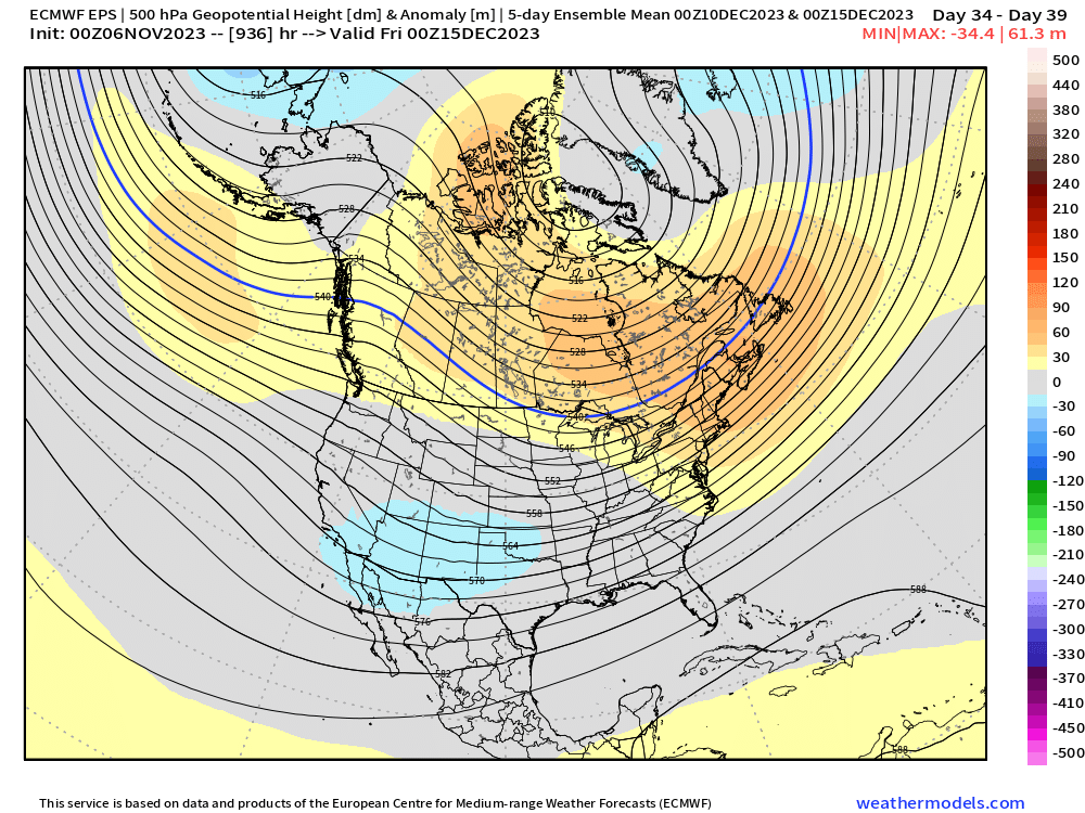
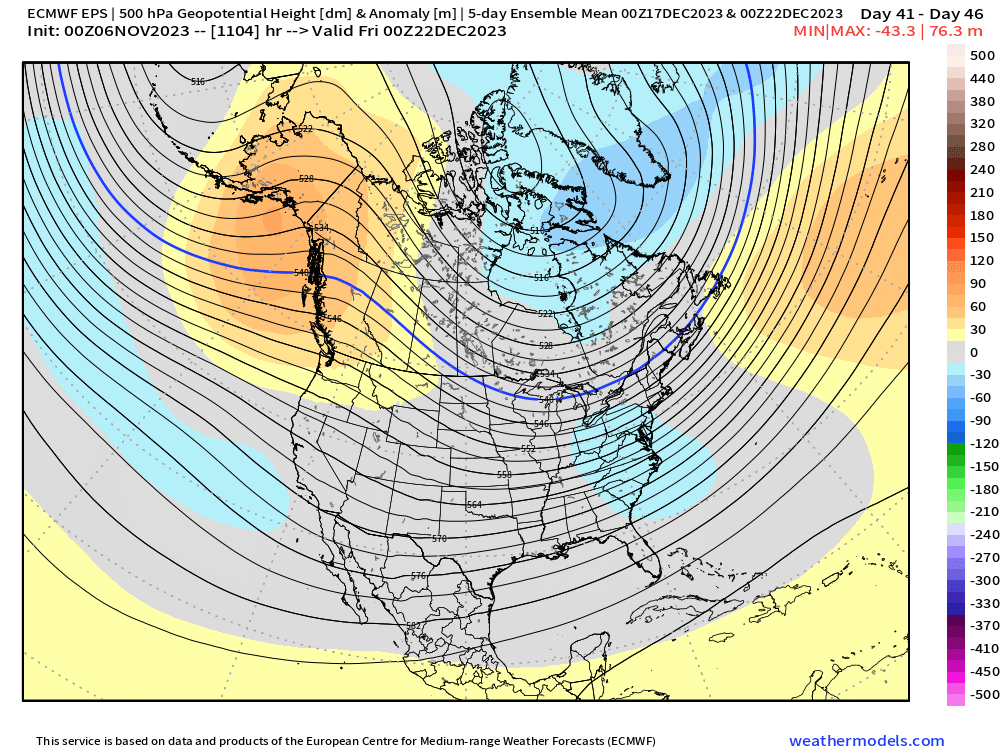
Yeah it really improved on the 5-day mean after about 12/17 or so….here’s the 5-day trailing mean on 12/15…you can see it’s still ugly And then the end of the run is 12/22 5 day mean which is a lot better…the pacific looks really good by then with the Aleutian low, -EPO/+PNA split flow with STJ …but obviously grain of salt that far out
-
Weeklies looked really nice for mid December and beyond too. I’m skeptical but nice look after a torch the first 10 days of the month.
-
Dec ‘88 and Dec ‘89 were like that. Though most of Dec ‘89 did have snow cover….but it was often very thin at 1-2”. But I remember so many brutally cold mornings with no snow in sight on the forecasts.
-
Yes, first half of next week is chilly....but then as the ridge builds in, we see big warmup....though there is still some model disagreement on the magnitude plus the GFS and Canadian have reinforcing cold shots late next week which would delay the warmth....but the Euro does not.
-
We'll have to re-cancel though when a reindeer farts in Siberia tomorrow and melts a few sq meters of pack.
-
A couple good days of snow cover in Eurasia have changed the calculus.
-
It wouldn't take that long to confirm breeding population...maybe a couple years max. I supposed it could be slightly longer if there was no active search for them and they remained in extremely low population areas....but typically breeding population will produce a LOT of sightings because the females stay in their established ranges and any adult offspring will then branch out into their own territories. You'll also start seeing evidence of kills by cougars....deer carcasses and stuff like that will start to be discovered relatively quickly if there's an established breeding population and they'd quickly be tested to see if it was a Mt lion kill or not. The breeding range is definitely moving east, but it would likely take decades to reach here without a reintroduction project. New England and upstate NY is probably the best cougar habitat in the country east of the Mississippi that could support a healthy population. It would likely be a huge benefit as a whole to get them back here (reduced car fatalities with deer, reduced disease amongst the deer population, etc), but a lot of public education would have to happen first.
-
Mountain lions don't have any breeding populations east of the Mississippi river other than the panther sub-species in Florida. But stray males can wander very far....the 2011 male that was killed in CT by a car had come from all the way in South Dakota. It had traveled through Wisconsin and Michigan before likely going into Canada before being spotted again in NY State and then it went SE into CT. You'll also get an occasional captive (legal or illegal) Mountain Lion escape that produces sightings in New England.
-
I'm not sure how we get a trimonthly value over 2.0 at this point.....Nino peaking in late Dec or Jan? Is November going to average over 2.0? If it doesn't, then you need BOTH Dec and Jan to average higher than 2.0C. The upper OHC down there looks pretty weak to be able to sustain those types of numbers....but I'm open to the possibility if everything breaks right I guess.
-
Next Monday could have some snow showers around too if that shortwave is deep enough.
-
Regression is a b**ch.
-
The hyperbole in here gets out of control.
-
Who said wintry through month-end? I feel like the mid-month warmup has been very well advertised. A couple GFS runs were trying to delay it a bit but it’s never looked like full winter through the whole month. This next week to ten days is decently cold in the means. I think people don’t get that climo is still highs in the 50s right now.
-
White Tday further inland at ORH: 2018 2014 2005 2002 1996 1994 1989 Mix of great winters, ok winters, and shit winters.
-
Yeah i have no idea why he was saying “MEI favors modoki”. That made no sense to me. It’s obvious this isn’t a modoki Nino but it’s also obvious the MEI is lagging this significantly compared to previous strong El Niños.
-
Super or Strong Nino December snowfall at ORH: Strong: 1957: 2.2" 1965: 2.3" 1987: 12.9" 1991: 14.5" 2009: 20.7" Super: 1972: 13.8" 1982: 6.4" 1997: 22.3" 2015: 1.4" A mix of duds, average, and good months. But there are twice as many duds as "good" months, which makes sense given Nino climo. But OTOH, 5 out of 9 were average or better.
-
Super...not strong. Last strong was 2009
-
GFS was a weird run....sort of delayed the ridge rolling over and allowed a couple reinforcing cold shots through 11/16
-
I made a comment in here about his posts....I don't follow him on twitter, but every time I see a post in here of his, it sounds really snarky and condescending. Not a good way to conduct scientific inquiry.
-
La Nina Decembers tend to be colder but that didn't work out the last 2 years. It's a crude rule, but probably doesn't work like 40% of the time. Also, at the end of the day, very few care whether the month was +2 or -1....they care if we got some good snow events....or even one well-timed snow event the week of Xmas or something. That's all 90+ percent of the posters care about. I can guarantee if we had a -1.5 December but a couple nasty cutters with little snow to show for it, the melts would be just as strong as if it was December 2022 all over again.
-
Weeklies had a +PNA burst in late November during Tday week so you could see how if that didn’t break down quickly, you could open December on the colder side.
-
Mid-Nov is high confidence because it's not that far away and decent model agreement. Early Dec is way less confidence. Weeklies are warm there, but those change a lot when it's week 4 and beyond. El Nino climo would support a warm December....esp early December, but there are plenty of El Ninos that didn't follow that route.
-
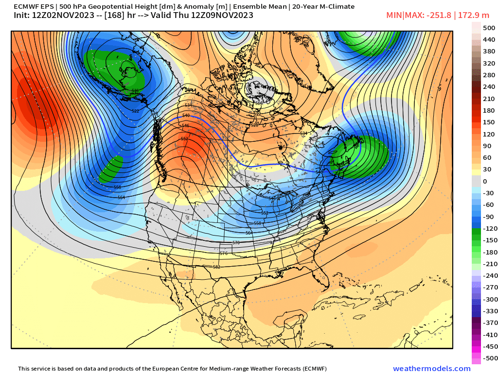
The storm threat for us wound be late next week. I don’t see much else beyond that on the ensembles. We warm up mid-month….then beyond that is anyone’s guess at the moment. Weeklies today still have that PNA spike Tday week which looks stronger than last run so we could be chilly that week if it verifies…then it morphs into a big GOA low to start December which torches us for the first 10 days of the month before they reload the EPO/PNA ridging mid-December with split flow and STJ which would be a really nice look….but that’s the end of the run so really take with a grain of salt anything past week 3 or 4.
-
Still a signal for some potential late next week....not favored, but worth keeping an eye on.

-
Just dump it in N ORH county or something....it will be fine there. Hell, we have bears around here...multiple sightings every year but I don't think they've ever had to euthanize one or even relocate.