

ORH_wxman
-
Posts
93,099 -
Joined
-
Last visited
Content Type
Profiles
Blogs
Forums
American Weather
Media Demo
Store
Gallery
Everything posted by ORH_wxman
-
You typically like to see the below: 1. Consistency across multiple runs and the pattern doesn't get "pushed back". (e.g., if the 240 hour pattern shows up mostly the same two days later at 192 hours, then you have consistency) 2. Cross-model support. This is when different model suites agree with eachother. If a great pattern is shown on the Euro/EPS, but the GFS/GEFS don't show it, then confidence is lower. But if all the models are showing it, then you'll be a lot more confident. 3. Is the pattern supported by other variables? If a great east coast pattern is coinciding with tropical forcing around the dateline or a retrograding Scandinavian ridge, then we will also be a bit more confident. We call that "Constructive interference".....it's helping the pattern be good. When those other factors might be at odds with the good modeled pattern, we might worry that it won't materialize as good as models show....we will sometimes say "destructive interference" is causing problems with the pattern.
-
Dec '17 was the last excellent December here in terms of sustaining cold and snowpack....we got like 7" on 12/9 and then never lost the pack until that mid-January 2018 monster cutter/thaw period....we had a couple of semi-mild 40-45ish days in mid-December that year but not enough to melt out the pack (very low sun angle FTW). Then we got another inch of snow and then ice on top of it on 12/22-23....then of course the 12/25 morning storm where we had about 6" here. I don't expect anything similar this year...but I think an optimistic scenario might be something like we flip to a -AO/NAO pattern around mid-month and maybe can run into the holiday week at the end of the month with some legit threats.
-
2020 and 2021 were very good Decembers from a snow standoint, but both were marred by ugly cutters ....at least 2019 did have a smaller snow event around 12/18 to give us a white Xmas.
-
We all rejoice singing harmonies in celebration....

-
'86-'87 was big over the interior around pike-northward...though heavily skewed by a monster January. The Cape got a monster blizzard in February that missed the rest of the region. I think BOS had something like 2" from that storm while parts of the cape had 30"+. Your area was decent but wouldn't qualify as a monster that season. I think BDL had low 50s for snow IIRC?
-
There are likely to be some meltdowns in December if it goes classic El Niño climo. If we score a decent December though, then very good chance we’re off to the races. But a dud December would be favored. Even those very good mod/strong Nino years like 57-58, 65-66, and 86-87 all had dud Decembers.
-
Down to 28 on the hill. Some low to mid 20s though down lower when driving the oldest to school a while ago. Very heavy frost too, even up here.
-
Yeah, if we kept getting that general look in winter, we'd have a blockbuster year. That's pretty classic synoptically for a New England threat. I do expect that those higher heights down south will be replaced by lower heights as we get into winter and the El Nino STJ keeps juicing up....still some La Nina hangover going on right now.
-
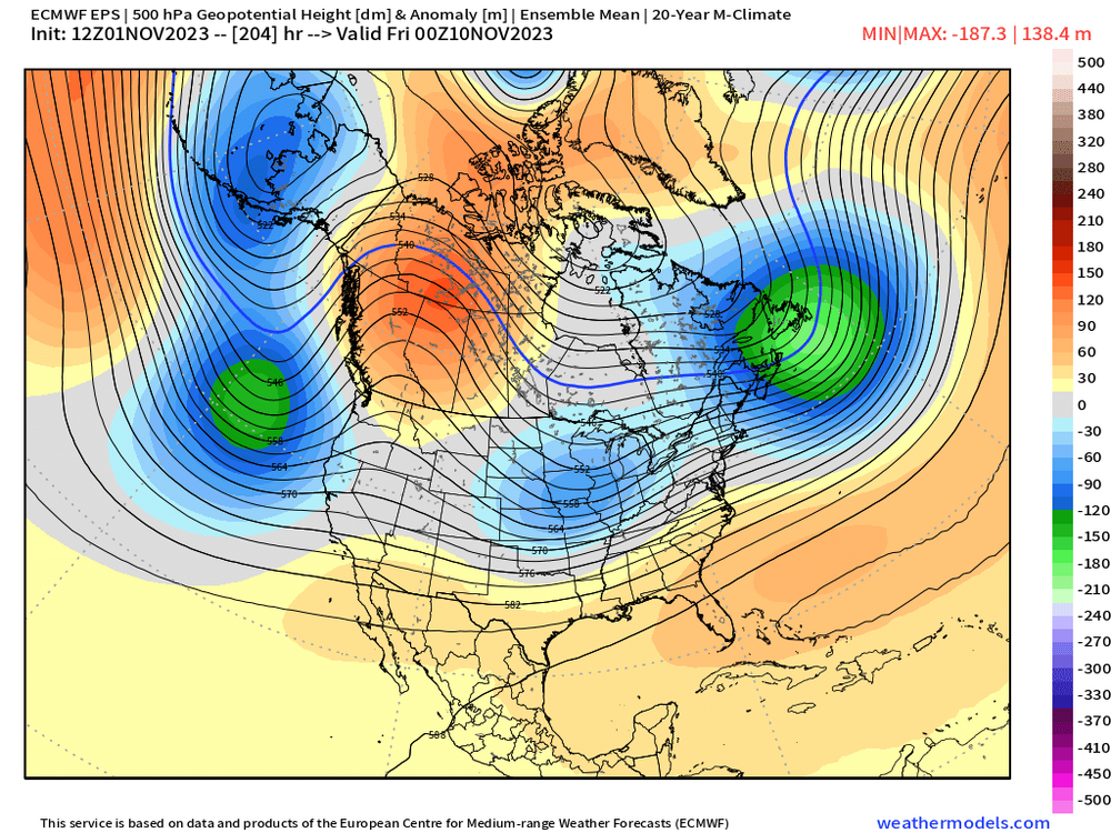
Fwiw, here's the EPS mean....you can clearly see some synoptic support for a wintry threat
-
Could probably count on one hand the number of times last winter we had legit BN airmass in SE Canada with a shortwave trying to amplify into it. Actually we might only need one or two fingers. It was that rare…we took it for granted for years….how many times did we get a mundane 4-8” front ender because we had a decent high and cold in place? Seemed like every winter it happened multiple times until the last couple where it was like trying to pull wisdom teeth.
-
Euro has that system as well...but it's more of a front ender....regardless, something to watch....especially given the calendar date. Not many are expecting winter wx this early in the season.
-
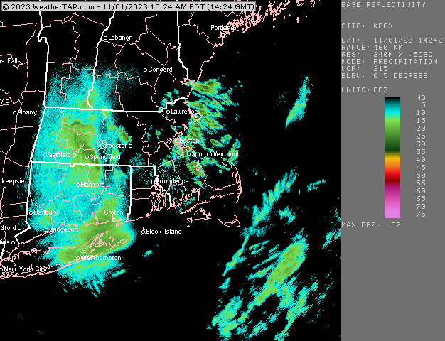
Nice streamer there....
-
Octorcher or Roctober 2023 Discussion Thread
ORH_wxman replied to Damage In Tolland's topic in New England
You can see ORH jump out at the end of that graph....I'd bet ORH sticks out like a sore thumb from summer 2020 onward. Years ago, I prob would've noticed right away, but it took until the Dec 5, 2020 marginal snow paste event for me to notice...I was on winter hill for that storm and cheap home thermo got down to 30-31F during the SN+ and mostly 32F otherwise while ORH was like 33-34F almost the whole time. -
12/6/09 and 12/2/75 are the two latest freezes at BOS....those are the only 2 that happened in December. 1968 happened on 11/30.
-
Technically not an El Nino but extremely close to one....2019-20 sucked after a pretty nice December. But of course, that season didn't remotely act like an El Nino....and it would be surprising if this one didn't given how much stronger it is.
-
EPS does have the synoptic signal for something setting up too...you can see the shortwave diving into the OH Valley while there's a 50/50 low and a Rockies ridge...pretty textbook actually. Just gotta get it closer than D10 and hopefully enough cold given it's early November .
-
Euro is intriguing for NNE for the 11/7-8 threat. Even flips SNE to snow after rain first....but that was one of the colder solutions in the past couple model cycles....still think something the following weekend in the 11/10-12 range would be a bit easier to get frozen out of (and clown range Euro does look interesting at the end of its run for that)
-
BDL was near 50" so you'd maybe a few inches less? 45-48ish?
-
He means snow.
-
Octorcher or Roctober 2023 Discussion Thread
ORH_wxman replied to Damage In Tolland's topic in New England
Yeah UHI only matters for the raw numbers...not the departure from average....unless the UHI is a very new phenomenon as to not be fully factored into the 30 year normals (something like Dulles airport between 1980s and 2000s had a lot of increased land use change)....and we know Boston isn't a situation like that. The same exact thing is going on with ORH for 3 years now....they are consistently 1.5-2F higher on the departures than the other first order sites....confirming what MADIS shows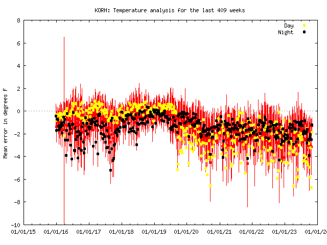
-
Octorcher or Roctober 2023 Discussion Thread
ORH_wxman replied to Damage In Tolland's topic in New England
And the record will never be corrected.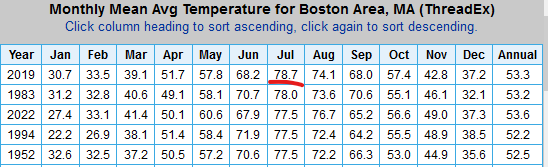
-
Yeah anything that says TAN and PYM average the same amount of snow is not correct. PYM is prob a solid 6" less.
-
I'd put Taunton in the 42-45ish range long term. They've been more than that recently, but the last 25 years is not the normal no matter how much we all want it to be.
-
11/8 looks kind of warm to me, though enough cold lurking nearby that an ideal track may produce interior snows....but there's another window after that in the 11/10-12 timeframe which looks like it has a lot more cold available.
-
There's no way Lancaster only had 13" in 2013-14.....that must be from the 2012-13 season.


