ORH_wxman
-
Posts
93,082 -
Joined
-
Last visited
Content Type
Profiles
Blogs
Forums
American Weather
Media Demo
Store
Gallery
Everything posted by ORH_wxman
-
Octorcher or Roctober 2023 Discussion Thread
ORH_wxman replied to Damage In Tolland's topic in New England
2020 redux without the snow pack....this actually might be worse because at least 2020 was a relatively calm evening....but man, it radiated quickly with the fresh snow cover. 1988 comes to mind thinking of brutal trick or treating with cold and a bit of breeze....that's what might happen this time too. I was only 7 so we made it to like 20 houses max before the cold got too bad. -
Octorcher or Roctober 2023 Discussion Thread
ORH_wxman replied to Damage In Tolland's topic in New England
After you originally told me the story many eons ago, I told myself that if I ever found myself in the past, one of my priorities would be to go to LA and find you and convince you to be in Boston for that. All while not sounding like a lunatic. -
Only 3 winters since 2008 (when snow depth records started there) have had fewer than 20 days of snow cover at the NWS BOX site....yes, last year was one of them.
-
Octorcher or Roctober 2023 Discussion Thread
ORH_wxman replied to Damage In Tolland's topic in New England
Wonder if Kmart will go aggressive for an early to mid Nov opening....pattern doesn't look too bad after the cold shot either. -
Octorcher or Roctober 2023 Discussion Thread
ORH_wxman replied to Damage In Tolland's topic in New England
Brutal cold for Halloween though. 516 thicknesses and flirting with -10C at 850. Gross for the trick-or-treaters. -
Octorcher or Roctober 2023 Discussion Thread
ORH_wxman replied to Damage In Tolland's topic in New England
Yeah I get that some people love it. I def like it when there’s a snowpack…even if only a few inches. But that bare ground during it is just brutal to me. Reminded me of some of those late 80s cold shots. -
Octorcher or Roctober 2023 Discussion Thread
ORH_wxman replied to Damage In Tolland's topic in New England
Yeah maybe. I don’t personally find a lot of solace in getting an extra arctic outbreak. We had a near historical one this past winter but it was pretty shitty without a snow pack….reminded me of? 1980s. -
Octorcher or Roctober 2023 Discussion Thread
ORH_wxman replied to Damage In Tolland's topic in New England
You must have been in NJ for this T-day event: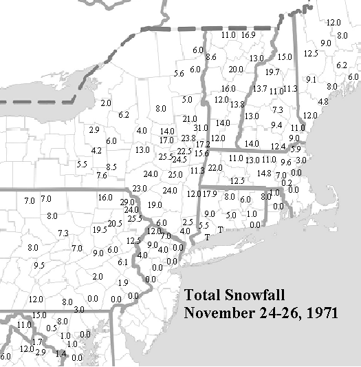
-
Octorcher or Roctober 2023 Discussion Thread
ORH_wxman replied to Damage In Tolland's topic in New England
The only positive I will say about the 80s, and this may be total bs and a clouded memory, but it seems like retention was better. Those frigid 85 and 89 periods could make a dusting last a week. Building a couple ramps on my sled hill, I could be going for three weeks on a couple inches. Retention was definitely better in the 1980s....it was colder. The problem was that there was often no snow to retain....lol....and when there was, it wasn't much. -
Octorcher or Roctober 2023 Discussion Thread
ORH_wxman replied to Damage In Tolland's topic in New England
Yes....if all anyone remembers is the good periods, then they aren't aware of the bad ones except maybe in theory or in the abstract. It's the same phenomenon growing up when we had to all listen to our parents wax poetic on how it always snowed all the time and there were no bad winters...."yeah no shit mom, you grew up during the one period in recorded history where there were 17 consecutive winters that didn't have below average snowfall". -
Octorcher or Roctober 2023 Discussion Thread
ORH_wxman replied to Damage In Tolland's topic in New England
2019-2020: 44.9 2020-2021: 77.7 2021-2022: 53.6 2022-2023: 47.2 -
Octorcher or Roctober 2023 Discussion Thread
ORH_wxman replied to Damage In Tolland's topic in New England
Not around here they haven't been....the dryness is the ultimate killer over interior SNE for winter snowfall. For ORH, the 1984-1992 period had 4 (!!) winters below 40" including a low of 28.1" in 1988-89. In the past decade, they have had zero winters below 40" with a low of 44.9" in 2019-2020. Even a warmer spot like KBOS saw a much worse streak as well....1984-1992 for BOS had 5(!!!) winters below 30" with 3(!!) below 20". In the past decade, they've seen 3 winters below 30" with 2 of them below 20"....and you could probably write off one of those below 30" as fake since it was the year when they measured on Deer Island sewer plant and recorded 27.4" when everyone else had at least 35"+ around them. The only futility BOS excelled at in the most recent decade compared to the 1980s was the lowest season was slightly lower (12.4" last year vs 15.1" in '88-89)....but overall, that 1984-1992 period was a lot worse. -
Octorcher or Roctober 2023 Discussion Thread
ORH_wxman replied to Damage In Tolland's topic in New England
ORH's latest freeze on record occurred in 1977....I think most would take that winter again. -
Octorcher or Roctober 2023 Discussion Thread
ORH_wxman replied to Damage In Tolland's topic in New England
Full blown snowstorm or just a snow event that covers the grass? I’d be surprised if we didn’t get one of the latter over the next decade or two. We’ve had plenty of November snow events in the past decade too including that big one on 11/15/18. You just have to line it up so it occurs on Tday. It’s definitely a bit tougher down in SE MA but they do happen. -
Octorcher or Roctober 2023 Discussion Thread
ORH_wxman replied to Damage In Tolland's topic in New England
For SNE, every single winter between 1984-85 and 1991-92 was drier than normal except the '86-'87 winter. -
Octorcher or Roctober 2023 Discussion Thread
ORH_wxman replied to Damage In Tolland's topic in New England
Yeah for many of us the 1980s reference is really mostly after the 83-84 winter through the 1991-92 winter which is something we should specify more often since any normal person would look at the entire decade....86-87 was spectacular over the interior (though I missed the majority of that one living in Texas at the time)....and '87-'88 was serviceable. But the defining feature of the mid 1980s through early 1990s was the lack of blockbuster periods or winters to offset the absolute turds. '86-'87 was really the exception (and mostly January 1987 at that). Of course, anyone who is very familiar with SNE first order climo knows also about the 10 year streak where Boston failed to record a 12"+ snowstorm....a stretch that started after the February 1983 KU event and ended with the March 1993 Superstorm. That brutal period also includes the only time that ORH did not record a 10"+ storm in 3 consecutive winters....and they actually managed to do it for 4 in a row ('88-'89 through '91-'92) just to make sure we all knew. -
The only time we had MJO forcing in the 8/1/2 regions last season was the second and third weeks of March.
-
Octorcher or Roctober 2023 Discussion Thread
ORH_wxman replied to Damage In Tolland's topic in New England
We often joke in here that rainy cutters followed by a frigid blast is a "1980s pattern"....those of us snow lovers who grew up with that remember all too well and not in a good way. -
Octorcher or Roctober 2023 Discussion Thread
ORH_wxman replied to Damage In Tolland's topic in New England
The irony is that Nov 2002 had some really cold periods because the tropical forcing went La Nina for a while. When I say "La Nina", I mean the typical phases we might see in mid-winter during La Nina. Those phases are usually warm in mid-winter, but they are cold in November (esp early/mid November) La Nina forcing is what also aided the frigid cold and multiple snow events in mid-November 1986. If you want to maximize the cold, then we'd prob want MJO in the "warmer" winter phases in November which tend to be colder that month as explained above, and then return to the 8/1/2 phases in December, which often happens in real La Ninas...that's why many LA Ninas like 2007 or 2017 have cold Decembers....because the forcing tends to go 8/1/2 in December La Nina a bit more frequently. El Nino is usually the opposite....crap phases like 4/5/6 in December and then it goes full winter as we go deeper into winter. Now tropical forcing isn't everything....we can be cold even when tropical forcing kind of sucks....but it usually takes something to overwhelm it like exotic blocking. -
Octorcher or Roctober 2023 Discussion Thread
ORH_wxman replied to Damage In Tolland's topic in New England
Looks like the MJO is kind of rotting near the phase 8/1 line as we go into November....that's actually a semi-mild composite for November despite being a very cold look in Dec/Jan....so I'm fine with it. That's where we want the tropical forcing to set up going into winter. -
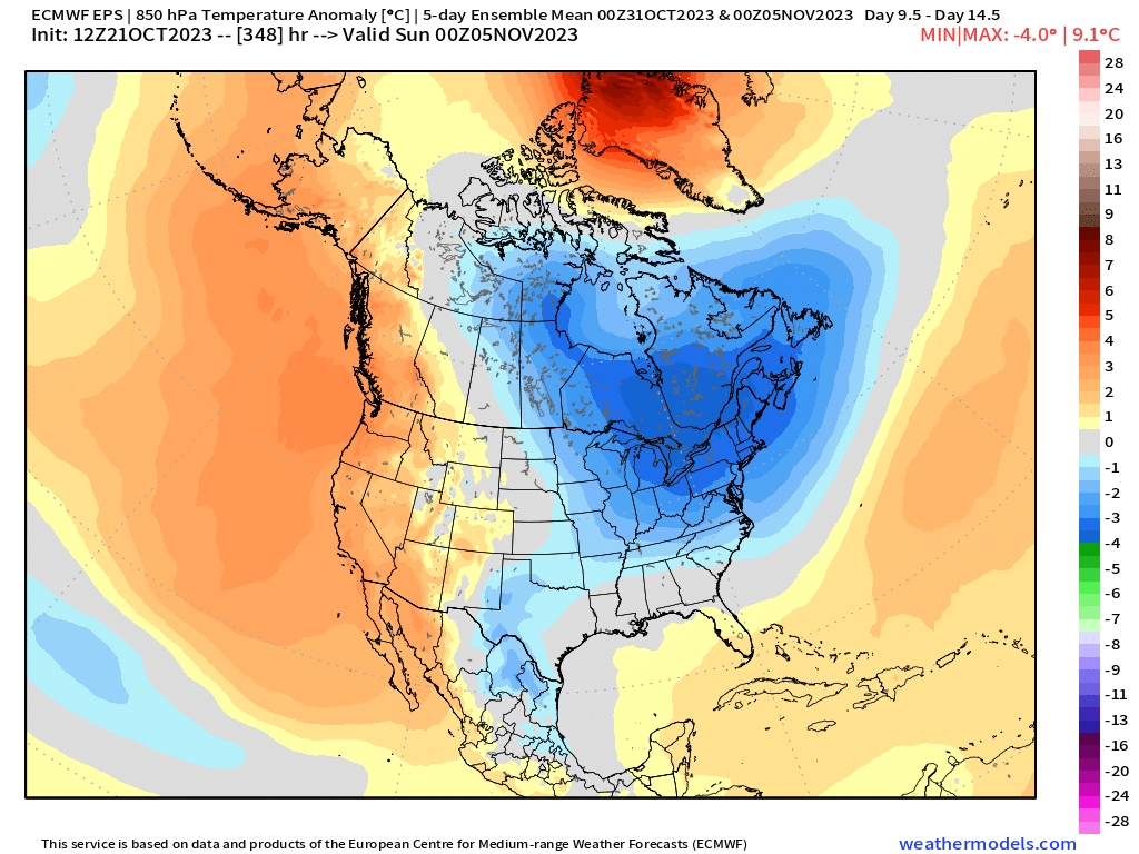
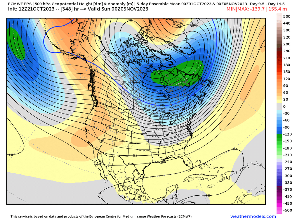
I’m not Tip but I’ll pinch hit for him on this one…first H5 anomaly (5 day average mean ending 11/5) and then 850 anomaly for the same period… At the moment, ensembles are keeping the cold relatively transient…lifting it out by the very end of their ensemble runs, but we know the caveats sometimes when changing into a new pattern…sometimes guidance tries to end it too quickly. So we’ll see how it all shakes out. But definitely a colder look coming in around Halloween into early Nov
-
Octorcher or Roctober 2023 Discussion Thread
ORH_wxman replied to Damage In Tolland's topic in New England
Pretty common for your area just west of the ORH hills spine to see first flakes on our first big cold shot on a longwave setup like a lot of ensembles are showing. That area tends to get some rotting flurries or snow showers from any dying LES that survive over the Berkshires…and then they usually dry up completely before reaching further east unless there’s a disturbance aloft to keep them going. -
Octorcher or Roctober 2023 Discussion Thread
ORH_wxman replied to Damage In Tolland's topic in New England
Yeah I mean we’ve had some ugly rainers recently in those awful Cabo San Lucas troughs but a canonical warmish pattern with decent precip will usually be plenty of snow up there. Even here we can go pretty snowy in a warm/wet winter. -
Octorcher or Roctober 2023 Discussion Thread
ORH_wxman replied to Damage In Tolland's topic in New England
Yeah. Actually looks an awful lot like 10/10/79…with that wave developing along the frontal boundary. Regardless, EPS is really hitting the cold hard on todays 12z run for Halloween and just afterward. -
If we’re parsing like 1.9 vs 2.0 then it’s completely trivial…but the difference between something like 1.7 and 2.2 would be noticeable for sure. I’m becoming skeptical this will act like a typical Super Nino anyway though even if we squeak over 2.0 ONI because the MEI is lagging so much.