-
Posts
93,092 -
Joined
-
Last visited
Content Type
Profiles
Blogs
Forums
American Weather
Media Demo
Store
Gallery
Everything posted by ORH_wxman
-
Fwiw, 06z EPS did come decently south. Get another tick at 12z and it's pretty interesting.
-
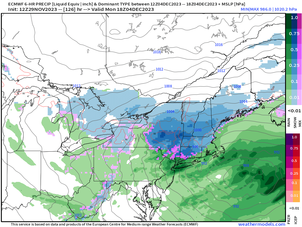
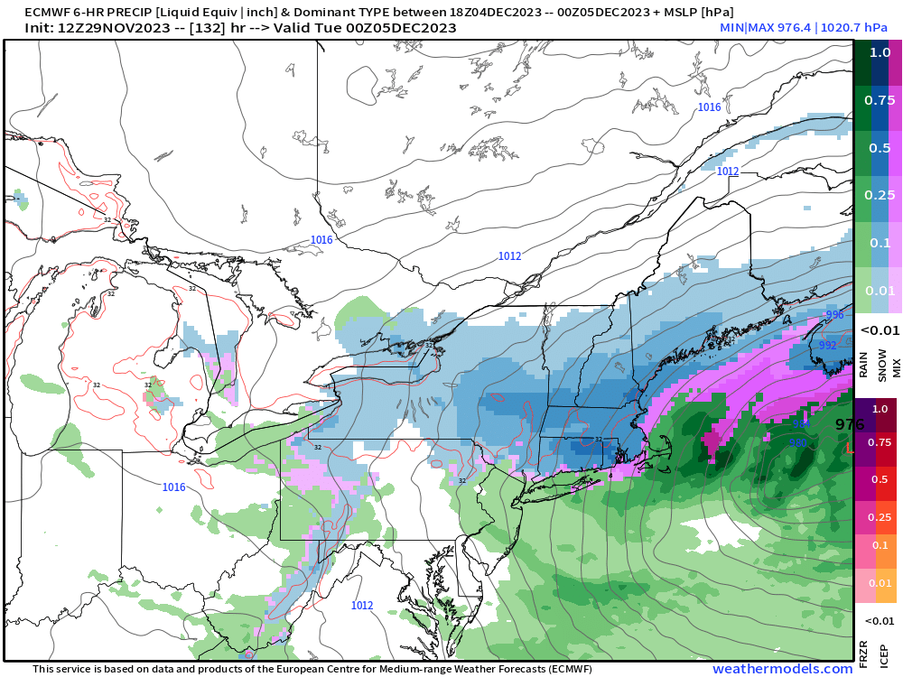
Euro already folded at 00z. It only had that solution yesterday that showed snow 126-132 hours out. Even in the old days that would’ve been a tough lift from that range. It’s wheelhouse was a bit closer than that. This one is still likely to change a few times but we’re probably going to want to see a colder trend at 12z to realistically get much of this forum back in the game outside of far NNE. CNE doesn’t need too much shift colder.
-
Yeah and I think many years ago a similar thing happened at SEA…they laid a new runway down and it really messed with the temps. I’m not aware of anything weird with the ORH ASOS though since 2020. I know they did move it from one part of the airport to another at one point in the past 10-15 years but that was well before 2020 IIRC.
-
00z EPS are pretty skimpy for SNE. There’s a few decent members but definitely a lot less than the 12z run which isn’t a surprise when looking at the warmth of 00z OP run. 06z GFS was another continuity break. Goes back to the Dec 6th idea which would be a colder look…but that idea has the least cross-model support and even the 06z GEFS aren’t that enthused. I think we’re gonna want to see some colder solutions on the 12z runs today to realistically entertain plowable snow in SNE.
-
I miss the 2003 and 2006 days of yore. Took them for granted back then.
-
Great pics. Was that the 2017 gathering? I remember me, Scott and Jerry looking at the NAM that night and thinking “hmmm, the 12/23 system doesn’t exactly look like a cutter…that looks really icy”….turned out to be legit icing right into BOS during that.
-
Yeah I feel like updates are way more frequent than years ago. I used to keep up with the updates without much effort back then and the biases were better catalogued. Even accounting for having a much busier life outside of weather now, it’s really hard to keep up with the changes even doing searches for 15-30 minutes.
-
18z GFS still focusing on different shortwave. It uses the 12/3 shortwave to bring rain even into NNE and then behind it gets colder to set the stage for 12/5-6 sort of like the 12z…except it fails to amplify as much as 12z so it’s nothing.
-
There are still a few members trying for Dec 6th too. Not as many as 12/4 but still worth keeping an eye on.
-
Maybe we move to 12/20 Wednesday? Bruins are off that day and Celtics are out playing in Sacramento that night so we’d be in good shape.
-
Normally we’d be pumped at a 126-132 solution on the euro but this thing has been changing every run so it’s prob gonna be a couple more cycles before confidence is high
-
That was a legit hit on the euro even for SNE. Not biting yet but there’s a nice little Hudson Bay block that forms and really holds that high in place.
-
Fwiw, I’d root for more of a GFS look as I think it’s a much tougher lift to get any part of that 12/4-5 impulse as significant snow in SNE. It’s probably better to use that system to drive down a better antecedent airmass in its wake and set the stage for the follow up wave to amplify into that airmass.
-
Which is not a valid response to an empirical argument…that’s why many posters including myself and CoastalWx jumped on you. You assumed there was some sort of bias driving the argument…and that’s fine to assume it since everyone has biases…but don’t expect to be taken seriously if you aren’t going to engage in the actual empirical discussion. Regardless of our biases, the empirical data is what drives the argument toward the truth. It sounds like you are pretty comfortable discussing data and metadata about stations. So it is surprising you wouldn’t just refute the ORH and PVD claims with actual empirical data.
-
That’s close to something big on GFS for 12/6. Meanwhile, the Canadian actually likes 12/5 for SNE. Models still trying to figure out the shortwave mess.
-
If you get to that area in the 5-6pm range right after work, you can find quite a few spots. Kind of that narrow sweet spot or window where people who were there during the day are leaving, but before the evening crowd arrives. But usually by 6:30-7 the spots are gone.
-
Those aren’t accurate numbers. Epping averages more than 61” and Exeter is much higher than 55”. Sometimes coop data is a bit unreliable…esp for snowfall. edit: Scott beat me to it
-
I have to admit I was in awe of that strawman he built….he sure had a lot of fun whooping its ass.
-
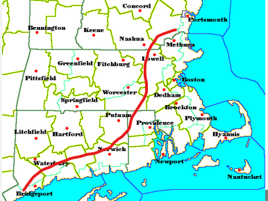
Prob draw a line from about Haverhill to SE CT and then back along the south coast.....roughly SE of the line I drew below
-
Man, all I have to do is count to forecast correctly? Who knew!!
-
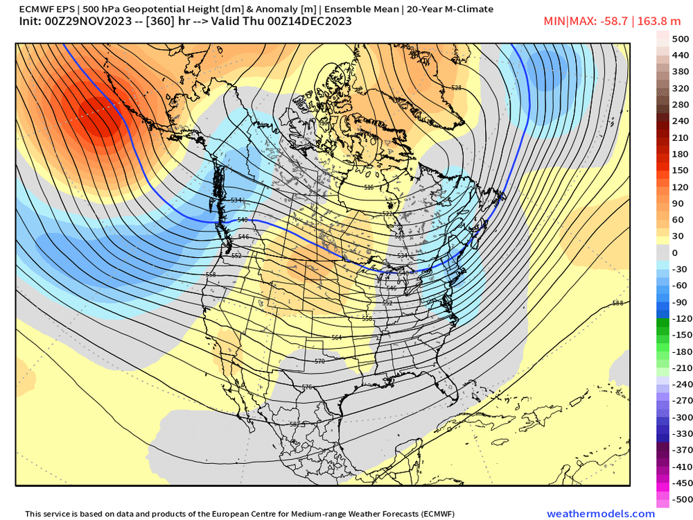
Yeah the mid-month pattern is really diffuse on guidance right now...like take a look at the EPS at the end of the run....maybe a -EPO hint forming there (preceded by -WPO burst?) prior to any PNA spike further down the road? Hard to say....but the notable part is just how tepid the anomalies are...that usually is a signal that theres probably a lot of disagreement amongst the ensemble members.
-
We might have a short period of torching mid-month if EPS is correct…but even if that happens, all evidence points to a nice reloading of a +PNA pattern by the final 10 days of the month. I noticed guidance is really uncertain about that Dec 10-15 period. That’s where it could go torch for a time, but it also wouldn’t be surprising if it was not that warm and near normal instead. It all depends on what the NAO does and if we also get any temporary blockiness in Canada instead of a well-phased ridge which would produce a warmer outcome here.
-
We used to always say “persistence forecasting works until there’s a big pattern change or a big storm, that’s when it fails you badly”
-
For a shorter time period you could explain away divergence from other first order climo sites and chalk it up to certain patterns being warmer or cooler relative to average for the coast, interior, or valleys vs hilltops, but this is basically 3 years worth of data where it is running warm. Maybe when I have time I’ll plot the monthly departures for all SNE sites on a single graph and the visuals for ORH will really stand out for the last 3 years and more recently we’ll see PVD going the opposite direction too cold. We’ve also compared KORH to mesonets nearby at similar elevation when airmasses are well-mixed…esp during the Feb cold outbreak when it was strong CAA where radiational cooling wouldn’t be applicable and ORH was running warmer than every single one of them. So even when I tried to debunk the MADIS divergence that started 3 years ago using alternate methods, I was unable to.
-
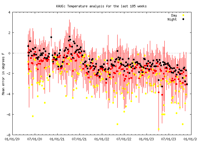
Good catch on AUG. Looks like it started having issues a couple years ago but the drift has accelerated in 2023 to make it more noticeable.


