ORH_wxman
-
Posts
93,099 -
Joined
-
Last visited
Content Type
Profiles
Blogs
Forums
American Weather
Media Demo
Store
Gallery
Everything posted by ORH_wxman
-
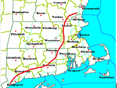
Prob draw a line from about Haverhill to SE CT and then back along the south coast.....roughly SE of the line I drew below
-
Man, all I have to do is count to forecast correctly? Who knew!!
-
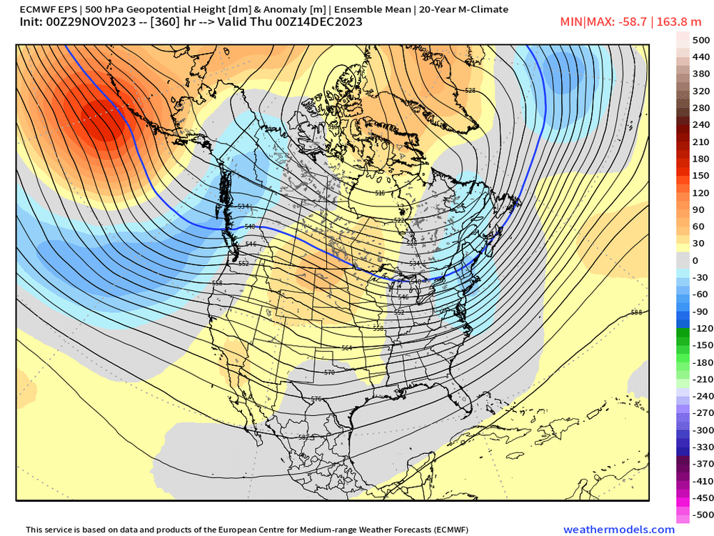
Yeah the mid-month pattern is really diffuse on guidance right now...like take a look at the EPS at the end of the run....maybe a -EPO hint forming there (preceded by -WPO burst?) prior to any PNA spike further down the road? Hard to say....but the notable part is just how tepid the anomalies are...that usually is a signal that theres probably a lot of disagreement amongst the ensemble members.
-
We might have a short period of torching mid-month if EPS is correct…but even if that happens, all evidence points to a nice reloading of a +PNA pattern by the final 10 days of the month. I noticed guidance is really uncertain about that Dec 10-15 period. That’s where it could go torch for a time, but it also wouldn’t be surprising if it was not that warm and near normal instead. It all depends on what the NAO does and if we also get any temporary blockiness in Canada instead of a well-phased ridge which would produce a warmer outcome here.
-
We used to always say “persistence forecasting works until there’s a big pattern change or a big storm, that’s when it fails you badly”
-
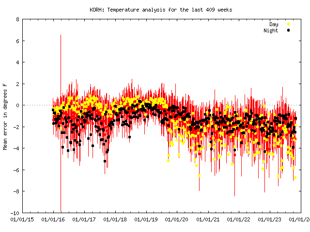
For a shorter time period you could explain away divergence from other first order climo sites and chalk it up to certain patterns being warmer or cooler relative to average for the coast, interior, or valleys vs hilltops, but this is basically 3 years worth of data where it is running warm. Maybe when I have time I’ll plot the monthly departures for all SNE sites on a single graph and the visuals for ORH will really stand out for the last 3 years and more recently we’ll see PVD going the opposite direction too cold. We’ve also compared KORH to mesonets nearby at similar elevation when airmasses are well-mixed…esp during the Feb cold outbreak when it was strong CAA where radiational cooling wouldn’t be applicable and ORH was running warmer than every single one of them. So even when I tried to debunk the MADIS divergence that started 3 years ago using alternate methods, I was unable to.
-
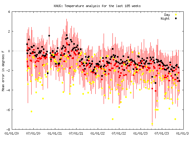
Good catch on AUG. Looks like it started having issues a couple years ago but the drift has accelerated in 2023 to make it more noticeable.
-
Almost allows Dec 6th to get us but still a bit wide right.
-
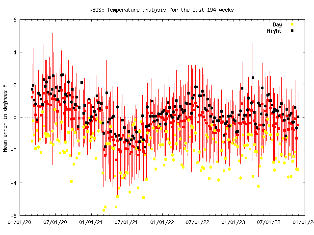
Oh that’s right. 2019 was the big one. There was something going on in 2021 too but not as ridiculous as that drift in 2018-19
-
I also think KBOS record in 2021 was erroneous too. @CoastalWx and I talked a lot about that one at the time. They fixed that ASOS fairly quickly though so the bias didn’t last beyond 2021.
-
The thing about individual sites in New England is that it’s very easy to compare data…we have a fairly dense network of climate sites and mesonets. PVD is absolutely running too cold too. There is plenty of empirical evidence for both PVD and ORH biases. If one wants to ignore that empirical evidence, then that is fine…just don’t ask others to agree with you unless you provide some strong empirical evidence to counter those claims.
-
The empirical evidence for ORH running too warm is overwhelming. I’m not sure how you can look at data for more than a few minutes and conclude otherwise. Even if you do not trust MADIS, just compare sthe ORH monthly departures to other first order climate stations in SNE and you’ll see consistently that ORH runs warmer. They are also consistently warmer than just about every single mesonet site at similar elevation near them. I’ve looked at this extensively since discovering the issue. Here’s the MADIS graph on a longer timeline. Pretty obvious step change in 2020 that also aligns with ORH’s divergence from other first order sites on monthly departure
-
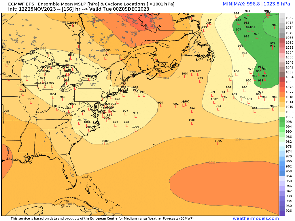
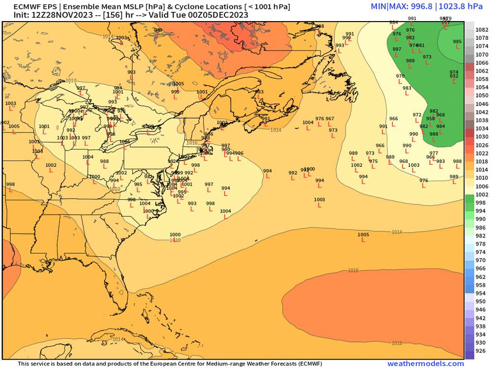
There’s at least some clustering down off the Delmarva on the individual ensemble plot…but still pretty buckshot overall which is not unexpected D6-7

-
Agreed we’re not far off on threat probability but I’d prob trade spots with you on this particular setup all else equal. Latitude really helps on that look as it appears on guidance right now. Might be enough to outweigh ocean influence…esp since the high looks decent so you won’t really have to worry about a big east flow off the water…but I’m starting to digress into details that could easily change.
-
Yeah last winter was comical on the high placements. Hopefully we get some positive regression this year on that front. Why not start with this system.
-
Yeah ideally there’s enough spacing for both waves but that might be tough. EPS does have several of the Dec 4th solutions cold enough for a chunk of SNE but a couple of the even snowier looks for most of SNE seem to be on the Dec 5-6 wave. Im not overly optimistic yet where I am in the interior…anything shovelable would be gravy this early. But there’s enough of a chance to monitor.
-
There’s some good members in there…esp for northern half of SNE. But a few get everyone. At least there’s a reason to look at guidance inside of D7 right now.
-
Euro is a close miss for a follow up wave on Dec 6-7. So that’s one we may have to watch as well. Still think 12/3-4 is a heavy lift for SNE big snow, but not so much for NNE.
-
Nice hit for CNE/NNE on euro for 12/3-4 system. A pinch colder and we can get SNE into the game. There’s likely going to be another chance though behind that system. Lot of shortwaves in the flow.
-
I think you’re started there. Unless an unforeseen long duration cutter or something happens, the pattern going forward doesn’t look close to warm enough to get rid of that.
-
Park at Alwife and take red line down to Park St and then it’s about a 5 min walk.
-
The flow has like 3 shortwaves embedded in there and it’s probably going to be a clusterfook on model guidance to figure them out until we’re closer. That leading subtle cold press late this week into NNE will be pretty important too for setting up the baroclinic zone.
-
Tuesday 12/19 should work for me too but I’ll confirm.
-
Interesting developments overnight. Like Tip and I were discussing yesterday, seeing more of a cold push just ahead of the action. Not sure it will be enough for us, but we’re in the game on a lot of guidance. Still looks like primarily an NNE threat to me synoptically but one more push colder and that certainly changes.
-
Yeah hopefully we can get a solid event or two in during the final 2 weeks of the month for the holidays and then carry that into a great January pattern. Anything before that is gravy…and I do think the pattern prior to mid-month can support an event, it’s just a little harder given the imperfections plus climo still being a little skimpy in early December.