

ORH_wxman
-
Posts
93,099 -
Joined
-
Last visited
Content Type
Profiles
Blogs
Forums
American Weather
Media Demo
Store
Gallery
Everything posted by ORH_wxman
-
Yeah he almost moved to the snow pits of Lancaster or Whitefield when he was looking at properties. I always joke that when he was asking me about those properties, I was like the group of kids in The Sandlot that go “nooooooo!!!!” and start running after him when Smalls is about to climb the over wall to get the baseball unaware of what is lurking behind it. Then when he asked about that Randolph property at 1500 feet I said “that’s about as good as it gets in that area”
-
Yes that’s what I immediately remembered when I saw Hermit Lake. Phin had a couple diatribes about how misleading it was to call it “Gorham” in the PNS. They prob should at least put an elevation note on it…I’ve seen PNS reports do that before.
-
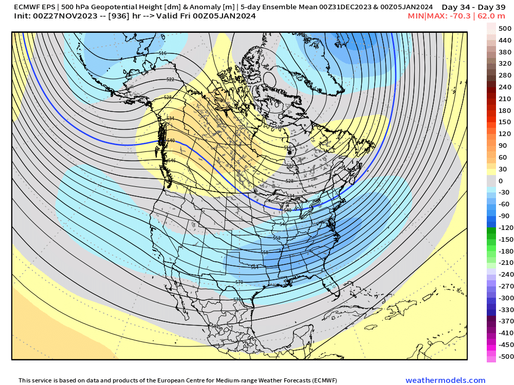
Weeklies looked decent after mid-month still. They go full-on weenie after Xmas and into January. 5 day mean leading into Xmas 5 day mean in early January.
-
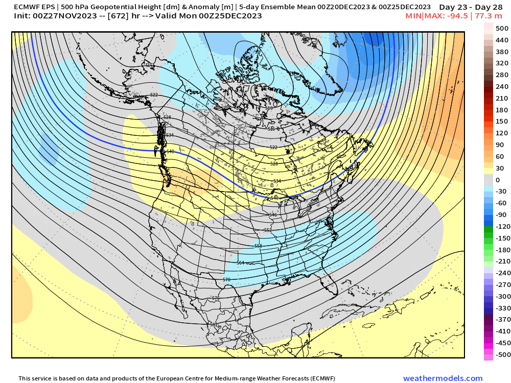
Still a lot of guidance disagreement for 2nd week of December....GEPS on the colder end, EPS on the warmer end, GEFS in between but prob closer to GEPS. This is likely due to the differences in the tropical Pacific where the EPS on the last few runs has had stronger forcing into phase 4/5 than the other model suites.
-
Oh yeah, I've seen that before....I think that's exactly what it is.
-
Yeah having been up in that area many times, there's almost no way they got that much with Wildcat/Pinkham getting 2".
-
Canadian comes close....nice for NNE, but we're not far off from something better here. Certainly colder than the 00z run....but we're obviously still about a week out so there's a ton of time for changes.
-
12/2 was the most popular pick so that date should prob stick...I'm going to be in Maine this weekend, so I won't be there unfortunately, but I will definitely try and make a local Clarke's pre-Xmas GTG if a few of us are interested in that. I am in Boston a few days a week now, so it wouldn't be very hard for me to come on over after work.
-
I think GaWX was using a true 2.0....not rounded. Since 1965-66 with its rounded 2.0 trimonthly peak is usually classified as "strong" and not "super" because it had an unrounded trimonthly avg below 2.0 (something like 1.97 IIRC).
-
There's another weaker signal for Dec 7-8 too....I think the Dec 4-6 one is prob too warm for us though...NNE might be different. Some of it will depend on how the NAO block shakes out....that could still correct the whole system south since the block will influence any potential 50/50 low and confluence in SE Canada.
-
That would be more toward climo anyway in El Nino....December is often a lost month, but I do like that we're seemingly in the game this month for some threats even if it's not Dec 1995.
-
Early Dec never looked great....esp south of us....there were some runs that looked decent for New England though because of the stout NAO block, but IMHO the best chances are NNE prior to about Dec 6-7ish. Biggest change on the ensembles is the EPS has the MJO going decently into phase 4 now whereas most other guidance is bringing it back into the COD prior to that....so the EPS doesn't look that good for Dec 5-11ish like it did previously while the GEFS/GEPS still look pretty favorable. I don't know if the EPS is correct since it's kind of an outlier....we'll see what it does today. The good news is that beyond that hasn't really changed much....it looks like we still loop back toward phase 8 just after mid-month so hopefully we get a nice run into the holidays and beyond.
-
Oh yeah that’s really cheap. Lol. I had initially thought it was they didn’t have a 1” event. Still a terrible stretch for them regardless, but those dual 0.9” numbers make that stat kind of dumb.
-
You were correct that it lasted more than one day…it just happened to be almost all of 12/11-12/12 so we can mostly leave 12/10 and 12/13 out of it for up here anyway. Further south, it was a bigger deal on 12/10
-
It was a 40 hour storm roughly. From maybe dawn hours on Friday 12/11 to late Saturday evening 12/12…some areas may have started slightly earlier or ended a little later but 99% of the impactful parts of the storm were on 12/11 and 12/12.
-
Nitpick but it was 12/11-12/12, 1992
-
Irony is in that ENSO thread where bluewave was showing how more recent blocks were south (therefore not helping us as much), we need this upcoming block to be a little more south to ideally keep us more in the snow game during the hostile PAC phase. A lot of these runs have it too far north and east for us. But it’s probably in a very good spot once the PAC goes a little less hostile. It also starts migrating SW with time as it retrogrades.
-
PAC trended worse in that first week of Dec than previous runs…it was already a hostile PAC but it went even more hostile. You have a solidly +EPO and a deep western trough with it. This isn’t a massive shock since you have MJO trying to force its way into the bad phases…it never reaches there in high amplitude but even weak bad phase is going to be working against us. The fact anyone in New England still has a shot at some snow during that is all due to the NAO block. PAC def becomes less hostile though after the 4th/5th or so.
-
I’ll admit Mar 2014 was a bitter pill to swallow. Threat after threat missed in all directions with like a -8 month.
-
‘13-14 was solidly above average in our area for snow. It wasn’t a blockbuster but Boston had nearly 60” that winter. ORH was 85ish.
-
That was a frigid winter…esp down there. And DC had like 5 or 6 decent events that winter. Not a one storm wonder year. Long winter too…iirc DC got smoked St Pattie’s day…that’s really late for them.
-
Errors theoretically should cancel out if they are random…some will be too warm and some too cold. There’s so many asos stations that we have a very good idea of larger scale temperature trends. But a corrupted ASOS at ORH for example is a major problem if we want to analyze temperature trends at that one spot. We’ll see a spurious jump in temps starting around 2020 that isn’t real.
-
ORH has been running too warm for 3 years now. PVD more recently has been running too cold.
-
First week of December might favor that with the semi-marginal airmasses. It would normally be a torch pattern but the NAO block keeps it marginal instead. Then the PAC improves after that.
-
The key word is “average”. Why would you just reduce predictions to a mean of a decade? That’s hideous and doesn’t tell you anything about an individual month in an individual year.


