ORH_wxman
-
Posts
93,099 -
Joined
-
Last visited
Content Type
Profiles
Blogs
Forums
American Weather
Media Demo
Store
Gallery
Everything posted by ORH_wxman
-
It’s def a boring pattern for now. When northern stream starts getting more active it will be interesting. Middle of this month has a classic December Nino ridge across central Canada which is a good bet for Stein around here unless you get lucky with a well-timed southern streamer…but I think we start shifting things more favorable in the final 10 days of the month.
-
Yeah his description fits with the weather that happened in 1975 even though I didn’t personally witness that. Big system between 12/20-12/22 and then cold. 1976 actually had a mini-grinch on 12/21 that wiped out a moderate event that fell 4 days earlier…and 1977 was just putrid and in the 40s for the week leading into Xmas which wiped any thin pack that was remnant from earlier that month.
-
Nothing will beat 1997 though…looked hopeless but then on the 21st we start seeing that chance of an inch or so on 12/23….the night before they said 1-3” inland but wouldn’t be surprised if it was less…then bam, 18” later. 2012 was also a fun one even though it was way less snow. Had about inch or so of currier and Ives fluff predawn until about 9am Xmas morning when it was looking bleak even the day before.
-
Based on the most recent decade being pretty skimpy, any linear regression trend on White Xmas around here is going to be negative. But if you throw another 2000s type decade on the dataset, then it might change it…we had a really brutal stretch of lean White Xmas in the 1930-early 1950s period…so if you started from there and ended in a year like 2010, you’d have a positive trendline. I don’t think it’s going to become more common than the 20th century mean though…a huge component of a White Xmas is keeping existing snowpack from melting out before that date and warmer temps simply make that harder. Even if you partially offset it with somewhat more frequent sizable events from working with more moisture.
-
He knows. This is his way to deal with no snow yet. It’s also CON he’s looking at and not CT…and even in the 1800s CON had plenty of duds. It’s true it’s a little easier now to have them, but not nearly to the degree which some in this thread proclaim. It’s not backed by the data. I’m pretty sure a chunk of weenies think that anything pre-1900 (or even pre-1950) was like a Quebec City climate in Boston….when in reality either period was still decently warmer than modern day ORH.
-
1875 weenies jumping off Old Man on the Mountain ledge….couldn’t sleigh until 2/4.
-
Yeah….I could also see a lot going right too…funny how that works!! The ridge is actually in the process of amplifying on that panel so that pattern is probably improving with time. That roughly lines up with the weeklies too.
-
Fwiw, the end of the run does have a pretty nice ALeutian low developing....but again, these things seem to change on a dime right now during this transition period
-
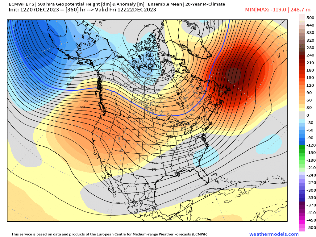
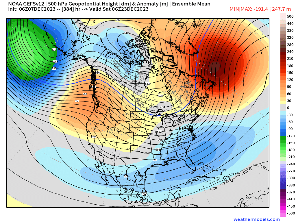
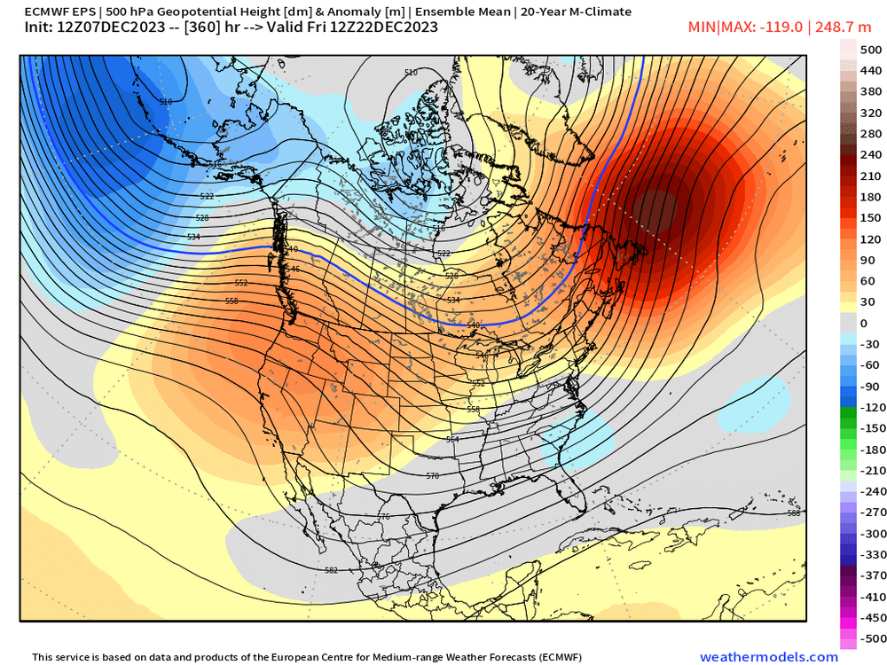
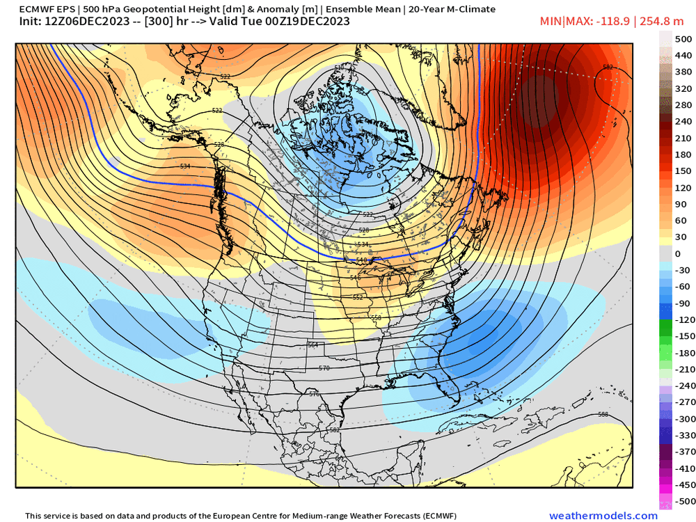
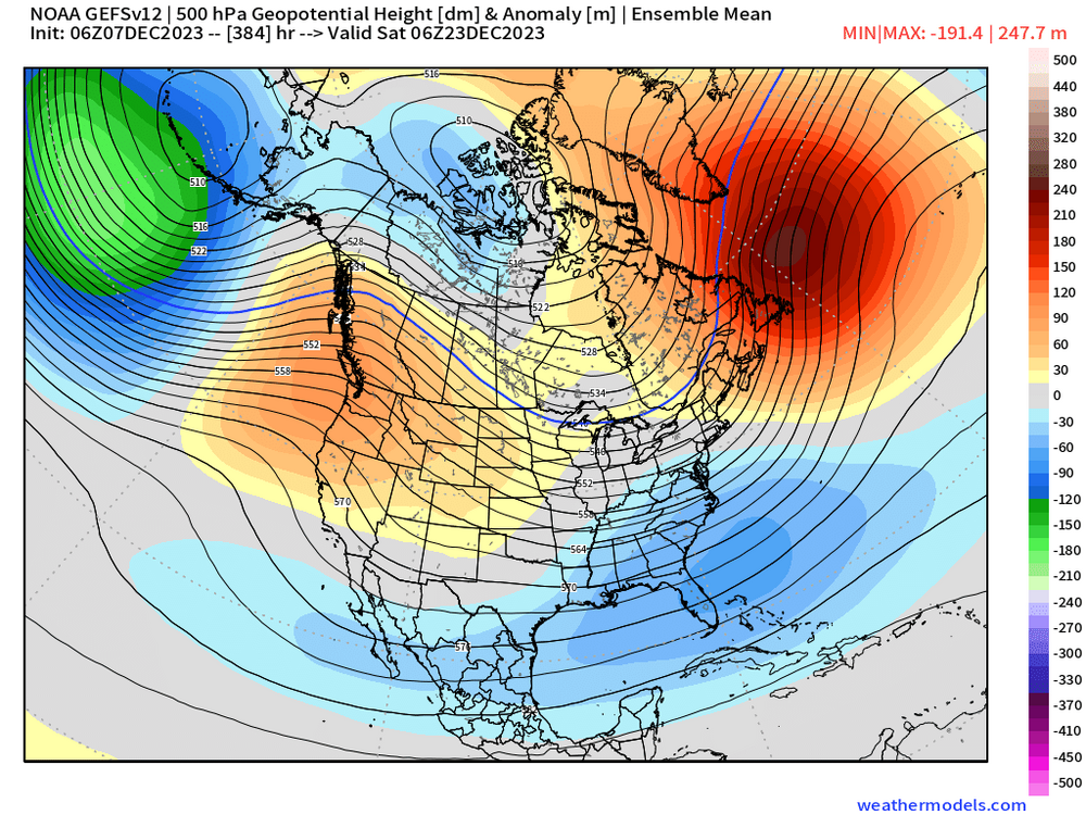
@CoastalWx Today's "ensembles are completely different from yesterday" session of the EPS....look at the PNA regions bouth south of the Aleutians and the west coast....this isn't even at the end of the run either. It's D11-12.
-
Some of the songs are a lot older too....like back when they had winter festivals on the Thames because it would freeze over during the height of the Little Ice Age in the 1600s/1700s.
-
I've always been a little surprised we didn't see some bigger October snow events over the years....but the water is just so warm in October, it makes it really hard for anywhere on the east coast coast to see it....acts as a pretty big modifier. The polar jet is also a bit weaker, so it's hard to really spin up excellent baroclinicity even when we do have decent cold airmasses in October....you gotta have the cold airmass but then back the flow off the water into that airmass without modifying it too much. Oct 2011 was able to thread that needle.
-
It hasn't even been 3 Decembers since we had a big December snowstorm. I'm going to list the number of warning criteria events in each December for ORH the past 10 years: 2013: 2 2014: 0 2015: 0 2016: 2 2017: 1 2018: 0 2019: 1 2020: 2 2021: 0 2022: 0 Do you know how many warning criteria snowfalls in December ORH saw in the 10 year stretch between 1982-1991? Exactly 2 and both occurred in Dec 1983. So they had zero December warning criteria snowfalls between 1984-1991. The problem is you (and many of us...me included) got high off the 1995-2010 December snow binge that we forgot that wasn't normal December snowfall climo....now we go 2 Decembers without a good event and the sky is falling.
-
This is what happens when unrealistic expectations are set in November....it doesn't snow much in November and the first half of December historically. We get some events but they aren't that common...and esp during El Nino. We also don't need perfect 2015 patterns to get good snow events....we like to see them on guidance because it creates more wiggle room, but many years we get snow events in merely serviceable patterns. While I enjoy looking at longer wave patterns, I feel we have progressed past the point of utility at times....if we were doing this exercise in like Dec 2002 (after the 12/5 storm) or Dec 2007....we'd have closed the shades and been "shocked" that these snow events started popping up on guidance when we got closer.
-
A lot of this stuff is also on the margins...like even the paper Tip linked was something like a 2% change in the speed for every 1C of warming. So you have a 204 knot jet streak instead of 200 knots....
-
Who is this dude from the Nintendo game? The polar bear dude dressed as a greaser from the 1950s who threw boulders at you.

-
The end of the 06z GEFS looked pretty nice...I don't trust anything beyond about D9-10 though right now because the swings and inconsistency have been remarkable compared to the usual D11-16 variance.
-
Didn't realize it, but BOS officially got 0.2" yesterday....so that's first measurable for them. Still think PVD and BDL are waiting on first measurable. ORH is sitting at 3.0" from November.
-
How is that different from any of the other 80-90% of years where snow hasn't fallen yet in early December there?
-
Hmmm not ringing a bell. Was it in December or earlier in the autumn? The only cutter I recall in Dec 93 was 12/21/93…it was more of a HV runner but we got into the warm sector and got windy. I don’t remember massive winds here but elsewhere in SNE wouldn’t have surprised me.
-
I’ll imbibe in a legit HWW event but they are generally so rare around here in the interior. The 12/17/00 one though was crazy. I think we gusted 65-70 and lost power for a few hours.
-
Xmas Eve 1996 was a good one too…ruined the White Xmas chances here but it was very windy. Not technically an so southerly screamer, but we had an epic wind nor Easter (esp on the coast) in Dec 1994 on Xmas Eve into Xmas day. It was subtropical iirc…no cold anywhere so it was rain even into the mountains of NNE despite a benchmark track.
-
12/17/00 was pretty epic…ironically that was a frigid month too but we had that one big screamer in the middle of it and it didn’t disappoint. Trying to remember the early 90s one being reference but can’t really. Though I tended to to ignore cutters back then so I don’t remember them as well as snow events.
-
I mean, just look at the EPO region…went from deep blue to orange in 48 hours. Horrific continuity…we wouldn’t be surprised on an OP run but for an ensemble mean to do that is notable. Shows how clueless guidance is right now.
-
Our batting average on these is like late-career Chris Davis levels. For every “hit” there’s like 10 whiffs.
-
He posted 60mph at 5k feet…lol But yeah, if it actually gets to 90+ knots, then there’s at least some potential to mix down 50+ at sfc, though even usually that isn’t enough because of inversion. edit: I reread his tweet…looks like he was just coloring minimum of 60 at 850 and not saying that was the cap…not sure why we’d even care about values that low. You’d prob want to start at 80+.