ORH_wxman
-
Posts
93,099 -
Joined
-
Last visited
Content Type
Profiles
Blogs
Forums
American Weather
Media Demo
Store
Gallery
Everything posted by ORH_wxman
-
Your BY is greater than 50% for white Xmas. It’s pretty common over interior SNE. But it can be noisy. We went 6 out of 7 between 2007-2013 (only 2011 missing)…then skunked for 4 years before 2017 and 2019. Now 3 duds in a row (though a chunk of SNE near and S of the pike had one in 2021 from that Xmas Eve snow event) If you’re S or SE and near the coast then it’s a different story. The chances are a lot less.
-
Yeah I’d mostly agree since even the turd spinning in the bowl in phase 7 for over a weak is going to eventually move down into phase 8/1 even if it’s weak by the time it gets there…but that’s still good. I don’t think we want a strong MJO wave anyway.
-
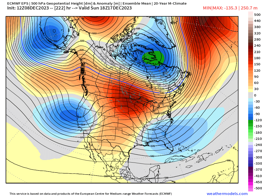
There’s a risk we lose the rest of December if that vortex near Bering doesn’t retrograde…some of the guidance just sinks it a bit south but it’s not really good enough. But OTOH, why should we believe that when this stuff has been changing so quickly. Could look completely different in a day or two. I think part of the recent solutions is I noticed most models stall the MJO in phase 7 for like 7-10 days. It rips through phase 5/6 by 12/14 and then it just….stops. Previous runs moved it into phase 8 by 12/19-12/20. If that part isn’t totally accurate, then we’re going to get more changes.
-
Had about 6-7” in that one. That basically started continuous snow cover here that winter until the mid-January thaw and cutter. Our best shot is prob 12/20-25 if we can get some of those more meridional solutions…guidance has been pretty wishy-washy on whether we torch or actually stay on the chillier side during that period.
-
I like the way the northern stream has been looking on some of the extended guidance around 12/20. So if the longshot of 12/17 doesn’t work out, there may be another window shortly after where there’s more cold to work with.
-
Yeah I made a post in the main El Niño thread this morning about it with @WxUSAF…there’s def a chance for come colder outcomes in that period. I don’t know if it will be able to save the 12/17 threat, but it could make the week leading into Xmas more interesting.
-
Most of the snow maps we see aren’t actually pure model output. They are snowfall algorithms using model data…which is why we have multiple options like 10:1 or Kuchera. There’s a reason I called them clown maps over 15 years ago, lol.
-
I was actually serious. Lol. It would be a fun read.
-
Congrats man. Another huge storm up there. Great start to the year there.
-
I actually mentioned something semi-similar in the New England forum about how the excessive EPO block (really a bit north of the classic EPO region…more into the Arctic Ocean) and the subsequent downstream PV near Hudson/Baffin has some correction potential to the south. This could be seen even in the week prior to Xmas. I know the post above was talking stratosphere, but those features are somewhat reflected in the upper troposphere.
-
Once you are retired from the regular rat race of 9-5 work, we need you to write a book about the psychology of the weather forums…maybe even document the changes from the early years of the 2000s to the incessant whining of the present day, lol.
-
The N PAC raging jet is a good sign because that’s how you get an Aleutian low to set up shop…something we haven’t seen this cold season yet consistently. Wont be much cold into Canada initially but we can still get threats (06z GFS is an example)…as the Aleutian low matures more, you hopefully start pumping up the PNA ridging and you begin to get some colder temps.
-
Actually gives us two storms…Dec 19-20 and then it looks like on Xmas day if it went one more frame. That would change all the whining in a hurry.
-
It would likely be that type of airmass if we got enough cold in place. But no way you’d expect a storm of that magnitude at this time range.
-
I think there’s room for that one to trend cold enough for snow. 18z GFs nearly pulled it off here…further interior got croaked that run.
-
I've always said the NW wind events in winter will outperform the southerly events 90%+ of the time. Maybe we can get a 3/8/05 stinger on the back end....wish we could get a few hours of blizzard like that one, but beggars cant be choosers.
-
18z NAM went east again....gets western SNE into accumulating snow. @RUNNAWAYICEBERGdoing naked snow angels while me and Ray get rained on?
-
I have some hope that one can correct colder. You have a big block N of AK and a PV in N Hudson Bay/Baffin….get that northern branch to correct SW a bit and maybe we have something. That correction would prob push the central US ridge westward a bit too.

-
Honestly, our region of the country has one of the longest lags…if people want the seasons to match the annual solar cycle, then they should move to the intermountain west. Many of them have their climo nadir in temps around mid to late December.
-
In La Niña it would be more concerning since December is supposed to be better during Ninas…but this year is obviously the opposite. The tropics are pretty telling so far this month…rotating the MJO through 4-5-6 is going to produce what we’re seeing now.
-
2/24/98 was a bad one.
-
This recent stretch is good for you my friend…it will teach you to appreciate the big winters. I was “lucky” enough to have the worst 4 year stretch in recorded history at ORH in my childhood so I was exposed to huge failure early on which really made those big winters feel a lot more special.
-
Almost time to roll the windows down on the explorer.
-
Looks like Stein….we get a cold shot on most guidance during that period but it’s dry. That could change but right now it looks boring.
-
2002 was pretty nice. Over a foot…I think you stayed mainly snow there too in Wilmington though maybe a period of sleet crap at the height for a time.