ORH_wxman
-
Posts
93,092 -
Joined
-
Last visited
Content Type
Profiles
Blogs
Forums
American Weather
Media Demo
Store
Gallery
Everything posted by ORH_wxman
-
About 0.5” in Holliston. Whitened the old snow but it will be gone by 2pm.
-
Southern areas where there’s less snow cover might pull it off before the arctic front.
-
That is pretty close to a 3-6” snowfall on Euro for pike on Friday night…just a fraction too warm. Pretty decent for S NH and down into Ray’s hood and Rt 2 area though.
-
What the hell, January 28-29 2025 FLURRIES
ORH_wxman replied to Baroclinic Zone's topic in New England
Sorry, didn’t post the map at first but posted above now. -
Don’t worry, we will welcome you back when the next good threat arises. The pattern gets to everyone eventually.
-
What the hell, January 28-29 2025 FLURRIES
ORH_wxman replied to Baroclinic Zone's topic in New England
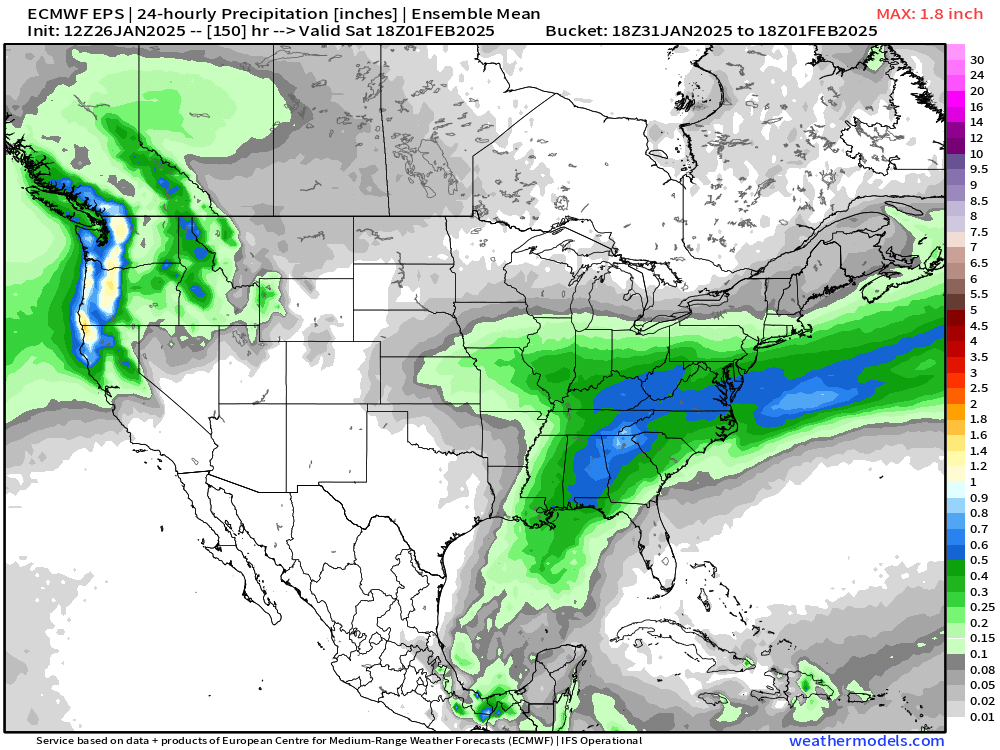
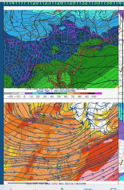
18z euro numbers on QPF. If snow growth is decent could be some 2-3” numbers…best chance up near NH border but decent coverage of 1”+ maybe. Could be a good burst just before sunrise Wednesday morning.
-
WINDEX numbers Wednesday late PM/ early evening are pretty impressive. The only thing we're missing for a huge event is the lift is a little so-so.....but everything else is really good. You have very steep lapse rates up to 600mb and plenty of low level moisture to work with. Hopefully the arctic front is consolidate enough to produce good lift.
-
Yeah this one looks dead unless we see wholesale changes to the leading low. Little clipper in Canada screws us which is too bad. We still get the cold press but we’d need the southern stream to slow down to make it good. Though there could be another one right behind it that might be worth tracking.
-
Yep…never bought the 12z run but I’ll gladly take a refresher couple inches Wednesday morning and run. I just hope it doesn’t slip north and whiff us or near-whiff. But it aligns decently with euro now.
-
Not exactly a zonked signal there.
-
EPS looks really suppressed. Might not even be much of anything on that look. Prob not the worst thing this far out though.
-
Yeah GFS is prob on crack. Seems like maybe a quick inch or two around here and then that’s it.
-
GFs had 8-12” several runs in a row around D3 but euro never bit except the one rogue 12z run (maybe 1.5 runs if you include that 06z run for eastern areas)…but yeah, if you were drinking GFS kool-aid while euro was not biting, then that’s on you.
-
That run mignt be more like 3-6”….not biting yet but nice trend.
-
GFS pretty weenie-ish for clipper for pike region up through S NH…has a nice IVT that extends the snow. Might be a solid 2-4”.
-
Almost always.
-
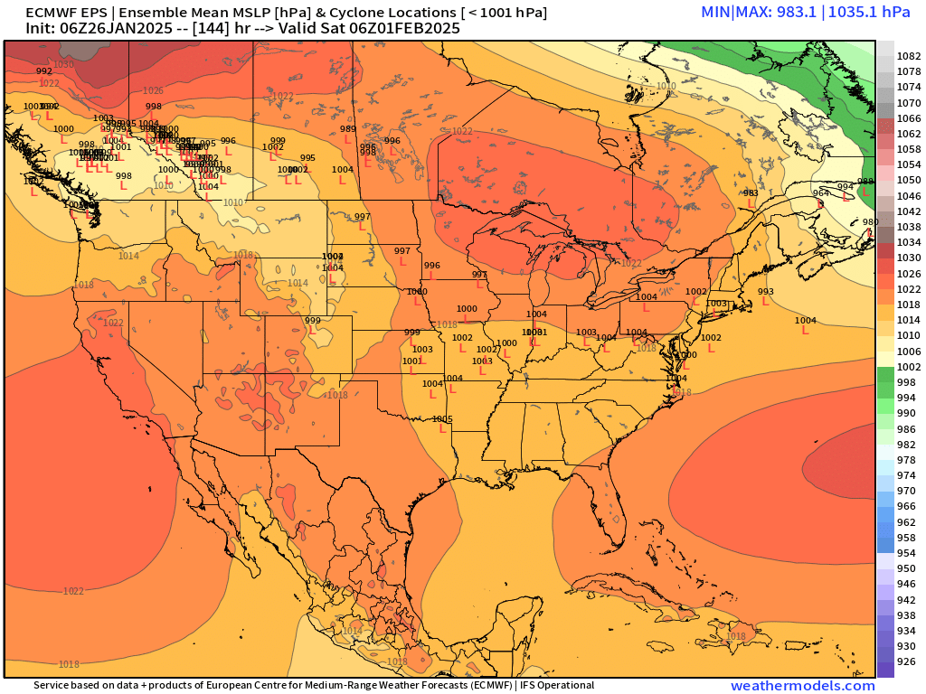
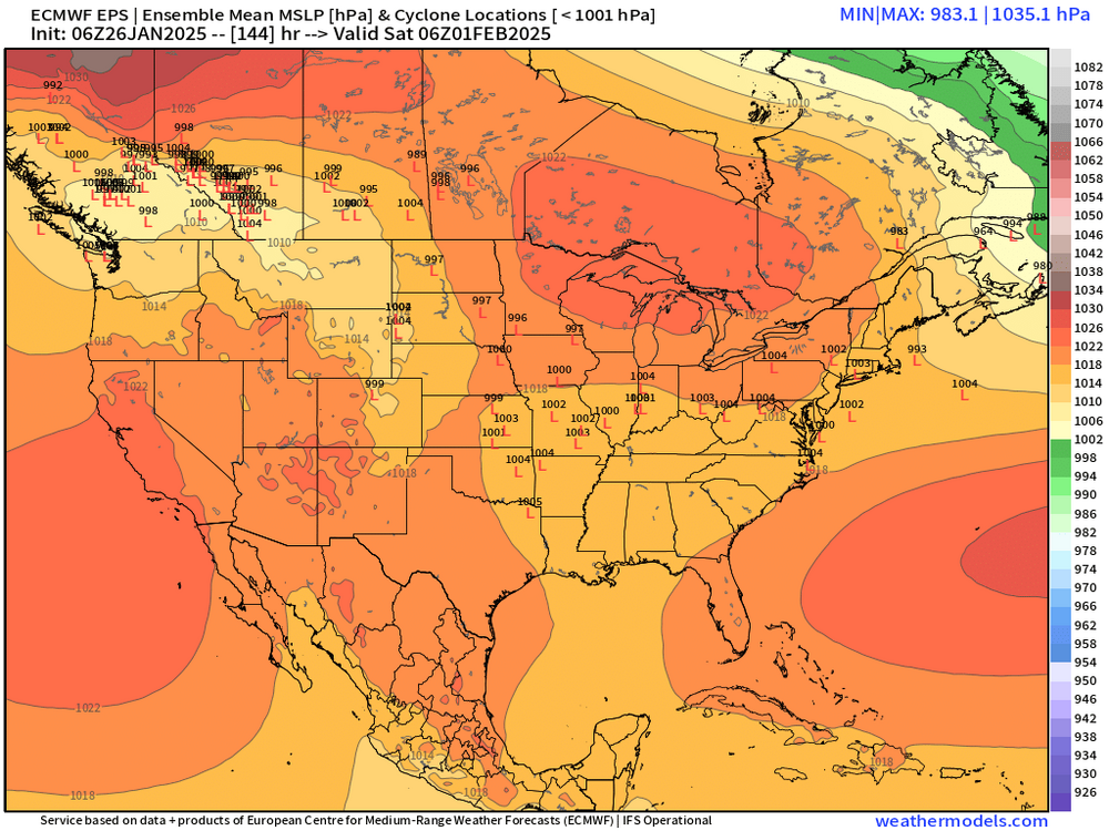
We’ll see how it trends today but it was a hard trend colder overnight. Even the 06z EPS was noticeably colder than the 00z EPS which had already trended colder with a CAD look. 06z EPS only goes to 144 but you can see how cold that look is right now with the low up in the maritimes and a scooter high building in as the low is in the Ohio valley…with potential for some weaker ripples of low already south of us by that point
-
Let’s get that looking more like 06z GFS which was pretty tucky for a lot of MA
-
Those types of systems typically only have a narrow area of ice and usually it’s not stationary enough to give big amounts. Once in a while you might get a narrow band of warning ice but it’s pretty rare. My guess is the frozen precip will be dominated by snow and sleet.
-
GGEM has gone colder on the 2/1 threat too. Shows a big front ender with the classic looking bent back ML warm front that we often see on SWFEs.
-
PDII the storm itself was kind of pedestrian in terms of rates. It was basically like 1” per hour for 15 hours and then another couple inches each side of it. As far as 20” storms are concerned, def somewhat “boring” But the modeling aspect of it was quite exciting. It just kept inching north every run from like 4-5 days out. It was a clean whiff on a lot of guidance at D4 and then just a slow creep north. GFS was last to the party as usual back then. Took until really close for it to hammer SNE.
-
Yeah had about an inch down to the pike. Slide that another 50-75 miles south and maybe it can infuse a little more moisture into it.
-
Euro tries for front end on that one.
-
First week of Feb looks tough for snow…although that could always change. Ensembles and weeklies both def look decently cold for second week of Feb. Maybe we can mimick Feb 1972 pattern…that was a La Niña with kind of a dud Dec/Jan for snow and then Feb start off as the typical SE ridge torchy pattern but then it flipped middle of the month and several snow events including a major one occurred.
-
Holden was always a great weenie town for snow retention too. It’s elevated but largely sits in sort of a shallow valley between 1200+ foot Princeton to its north and 1200+ Paxton to its south so it holds cold air really well too.