ORH_wxman
-
Posts
93,099 -
Joined
-
Last visited
Content Type
Profiles
Blogs
Forums
American Weather
Media Demo
Store
Gallery
Everything posted by ORH_wxman
-
Two distinct strong signals on EPS…the Thursday threat which is the warmest one…but it’s been trying to trend colder. Then next weekend (mostly centered on Sunday) which is a colder look for much of the region. There are additional weaker signals beyond that as the gradient pattern continues to provide chances, but those signals are weaker and more diffuse as you get out into clown range.
-
Yeah so it was the max temps for sure then if they are even on mins. ORH radiates like total shit as we all know so if rad pits we’re doing poorly, then ORH would have lower min departures but they don’t. Prob a lot of that westerly flow we talked about in the January thread is the biggest culprit. It affects all of us but BDL really gets affected more than anyone on that flow with their max temps. I wish we weren’t dealing with these shitty ASOS biases…I can tolerate a few tenths but being off by 2 degrees makes a mockery of this stuff.
-
If that’s the case then a lot of westerly downslope flow this month may make BDL still a bit warmer even when you adjust for their ASOS bias. They ran 1.4F ahead of ORH and their biases are fairly similar though BDL might be a few tenths worse, but that still leaves roughly a degree difference. Anyways, pretty flaccid cold departures in January relative to the very cold mid-level departures.
-
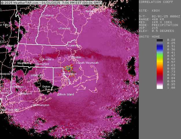
Looks like the snow line is near rt 2 or just south…low levels are still warm so this is the snow line a couple thousand feet up…but prob plenty of mixing and catpaws just north of it
-
So is ORH. Both are running warm. Lack of radiating this month though was going to make BDL a little higher anyway.
-
Much colder look on 18z GFS for next week. Some legit icing in that overrunner.
-
Def some bright banding moving into western SNE
-
I’m sure he’s on the edge of his seat for some wet flakes at the end. We really need to bring the weenie tag back….
-
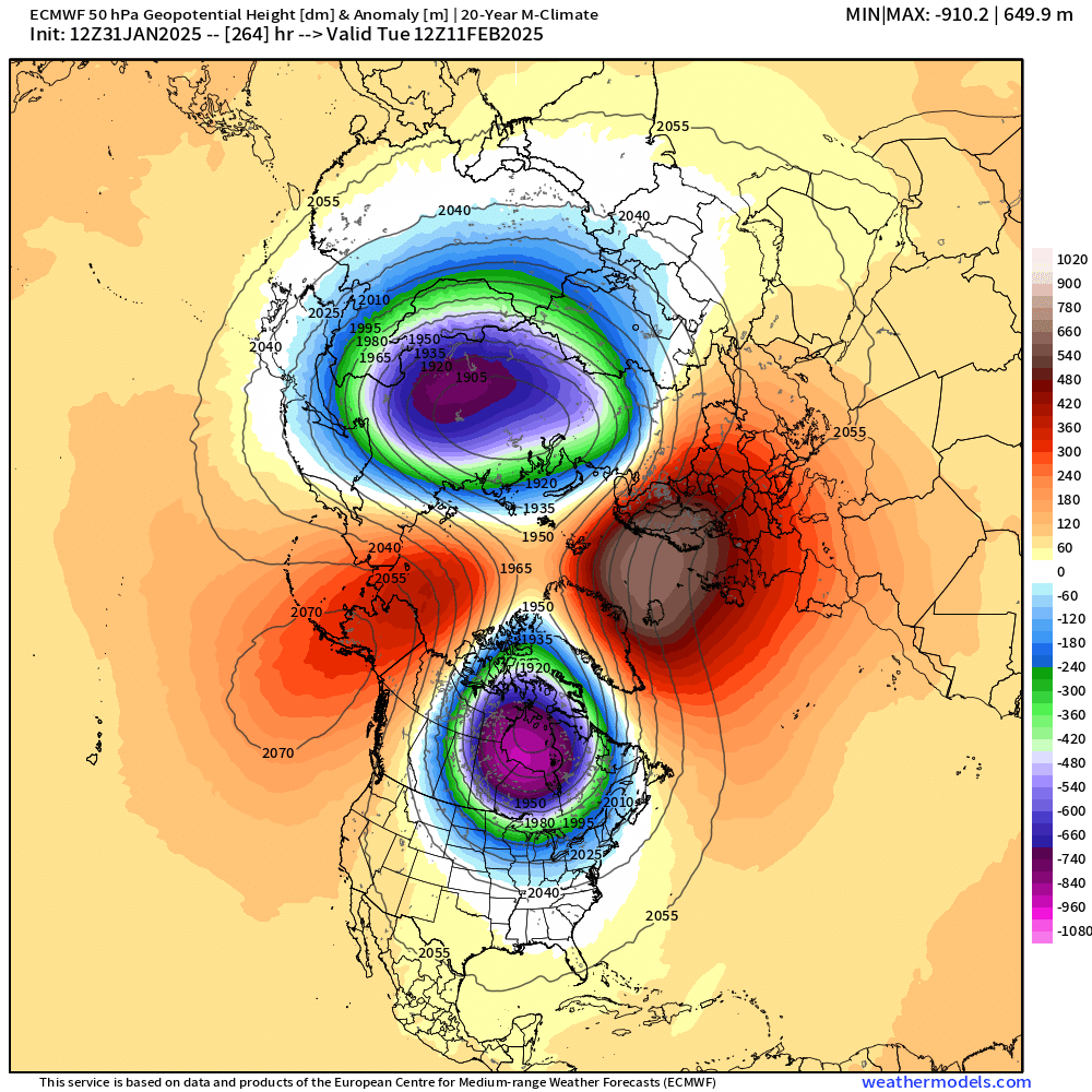
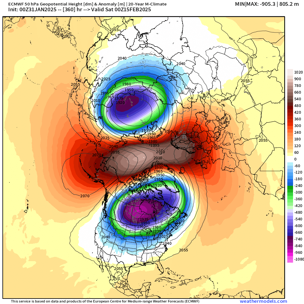
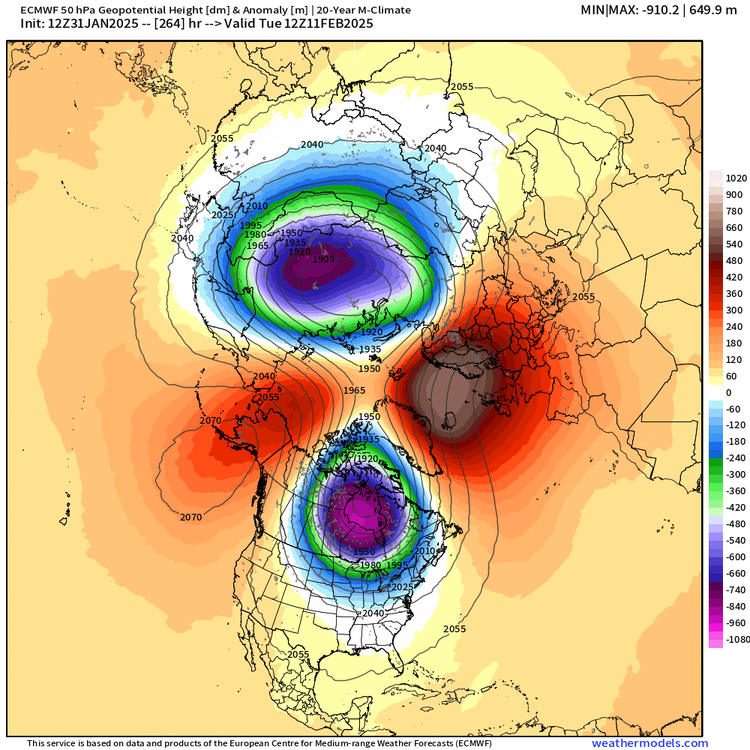
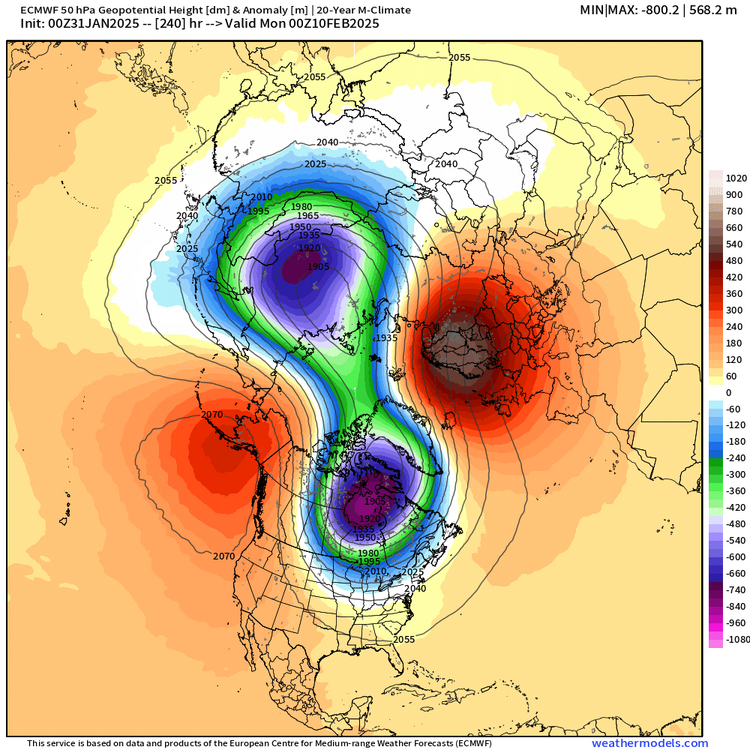
@CoastalWx, 12z euro actually destroys the 50mb vortex faster…obliterated by d11-12. Something to watch…
-
Yeah this is the type of pattern that is about as bad as it gets for model guidance in the medium/long range. Very high gradient with fast flow and an emphasis on what is going on in the fast flow coming out of the arctic regions which even in the age of satellite data is poor coverage up there. I’d expect lots of big shifts. Something that may look good at 6-7 days out could easily be congrats Montreal at verification…and vice versa.
-
SUNY MM5 was a go-to in CAD events circa mid-late 2000s
-
High variance though. Could easily miss out on those threats too. But yeah, the OP solutions could vary by 200 miles at D7 and beyond and even a 100 mile shift could be the difference between big snows and 65F flamingos.
-
Need a much better high to show up on guidance....trying to on GGEM and to a lesser extent GFS...but still needs a lot of work.
-
There's pretty decent support for the 50mb split on guidance right now. We'll see how it looks in another few days...but pretty silly to just dismiss the idea.
-
They might get more snow in Uganda than we've had this winter.
-
Nice early April day out there.
-
Phase with TPV in west-central Canada was a bit weaker/delayed this run (but not denied)....if we can weaken that further, then we'll keep better high pressure to our north...or at least have it take longer to slide east. Canadian shows this too....except even better.
-
Are you thinking of 1992? There was a snow event on those dates in '92....very cold March that year after a pathetic rest of winter. That one wasn't a big storm though...maybe like 3-6" type event. It did hit the I-95 corridor though too....kind of a clipper/redeveloper.
-
Yeah if we want to try for a big dog in March, this will increase our chances for sure. Usually lag time is only about 3 weeks if you're getting a big stratospheric event near 2/10
-
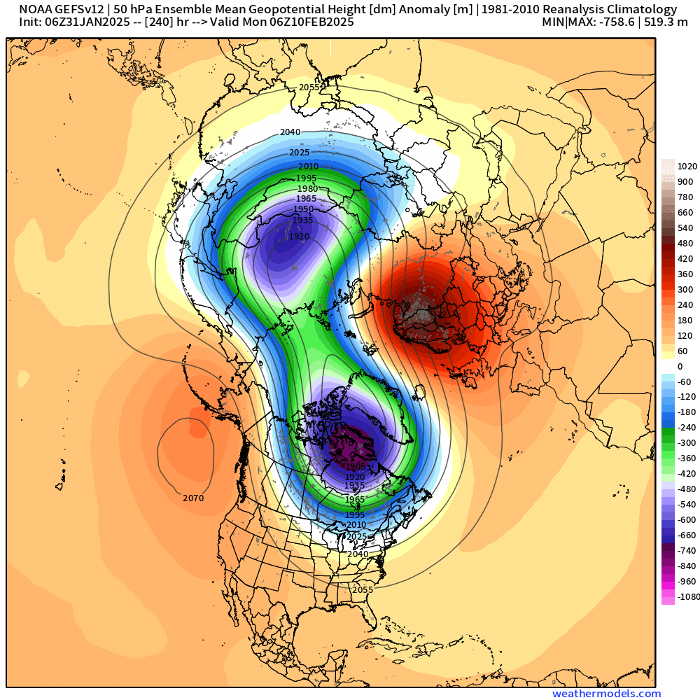
GEFS clown range
-
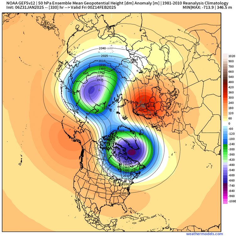
weathermodels doesn't show EPS stratosphere which is really annoying....GEFS has it though....but the GEFS signal is not quite as robust, but its def there

-
Out in clown range obviously by this point....but by the end of the run, it's obliterated

-
Euro has it splitting around 2/9-10
-
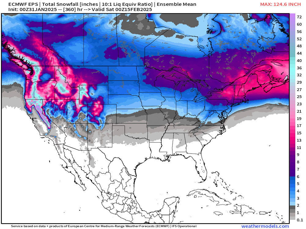
EPS has two decent signals for potential siggy snow...first one is 2/8-9 and the second is 2/13-14....the latter a much weaker signal of course considering the lead time. It's too bad we're getting a bit of a TPV lobe phase next week because otherwise, 2/5 would be a legit threat too. But I can't remember how many times I've said "too bad for a TPV lobe phasing out west" over the past 3 years.
-
You know it's exciting when half a page is taken up on a Gulf of Mexico/America discussion. On the plus side, the EPS continues to be snowier in the mean than any other time this winter....not saying I'm buying it, but I think ti speaks to the realistic potential for some good events in this upcoming pattern....as high variance/high volatility as it may be,