ORH_wxman
-
Posts
93,099 -
Joined
-
Last visited
Content Type
Profiles
Blogs
Forums
American Weather
Media Demo
Store
Gallery
Everything posted by ORH_wxman
-
Tracking February 6. Light to moderate event potential
ORH_wxman replied to Typhoon Tip's topic in New England
Yep and H7 (while a little less defined) was just inland from south coast during the thump. If the ML warm front is more diffuse and weak, we’re gonna get those ugly lighter rates. But if we can keep those features more defined, then it’s a nice 4-5 hour thump. -
Tracking February 6. Light to moderate event potential
ORH_wxman replied to Typhoon Tip's topic in New England
You want to be where the ML warm front is…just north of it. The triple point low rides pretty close to it so we’re gonna want it over the Cape/SE MA I think. This run showed a bit more defined bent-back ML warm front than previous runs so I think that’s why it was spitting out better rates. That little vort running out ahead of the main shortwave stayed a bit stronger too which helps with the midlevels. -
Tracking February 6. Light to moderate event potential
ORH_wxman replied to Typhoon Tip's topic in New England
Nice thumping band for pike on that run. -
Forget that. Let’s go this

-
It does. But it’s not vastly different than Thursday. A little colder on guidance.
-
0% chance you lose your pack this month where you are.
-
You can be “safe” and go cold/dry like much of January. Or you can play with fire and reap the rewards (or failure)…but no guts, no glory. This is as good as a pattern as we could ever hope for in a La Niña February.
-
The funny part about all the pack discourse is it’s prob getting covered again in 48 hours and likely reinforced on Sunday.
-
Tracking February 6. Light to moderate event potential
ORH_wxman replied to Typhoon Tip's topic in New England
3-5 with some IP/ZR has a lot more staying power than C-2…get two of them in a row and then you’re in business for trying to run the table to the end of the month if you can avoid the rogue cutter since there’s prob more threats beyond sunday. -
Tracking February 6. Light to moderate event potential
ORH_wxman replied to Typhoon Tip's topic in New England
Still looks like 3-4” pike northward but yeah, def skimpier to the south. Euro’s been waffling a decent amount on this one relatively speaking so we’ll see if that is the case again. -
Tracking February 6. Light to moderate event potential
ORH_wxman replied to Typhoon Tip's topic in New England
Euro and GFS are both pretty similar for SNE. 3-5” on the front end. NAM is staying paltry with the QPF but we’re still about 2-3 cycles away from the NAM being worth looking at. -
I had Swiss cheese cover for one day between Jan 11th and the MLK weekend storm…it was that rain on the Saturday that finally punched some holes in the cover. But otherwise it’s been consistent. This past Saturday got a few holes too in the sunny spots. Considering we’ve had like 9-10” total during that stretch, pretty good run to keep cover. Hoping we can actually develop a real pack from this pattern instead of this nickel and dime crap.
-
Tracking February 6. Light to moderate event potential
ORH_wxman replied to Typhoon Tip's topic in New England
I’m not sure if it’s going to be a consistent bias in modeling, but when you have very dense arctic low level airmasses in place, it’s a decent recipe for colder corrections on model guidance. Especially if you have some semblance of high resistance to the north or northeast. If you don’t, then that midlevel warm punch can scream in quickly. (Sometimes it does anyway) But it’s been a few winters since we had a lot of consistent arctic cold anchored over our region prior to storms coming out of the OH valley. -
Tracking February 6. Light to moderate event potential
ORH_wxman replied to Typhoon Tip's topic in New England
More daytime Thursday. First flakes might be just before sunrise down that way but most of it falls during morning/midday hours from southwest to northeast. -
Tracking February 6. Light to moderate event potential
ORH_wxman replied to Typhoon Tip's topic in New England
Euro tickled colder again. 3-5” on front end for just about all of SNE save for far SE coastal zones where it’s closer to 2”. -
Tracking February 6. Light to moderate event potential
ORH_wxman replied to Typhoon Tip's topic in New England
Pretty solid advisory snows on the front end all the way into SW CT. Then a period of IP/ZR before dryslotting. Decent little event if it can break that way. -
Tracking February 6. Light to moderate event potential
ORH_wxman replied to Typhoon Tip's topic in New England
Useless at this range though. I guess I’ll take it trending colder rather than the other way around but at the 66-72 hour range I’m still mostly just looking at the big boy models. -
BOS at -7 that late would be crazy. BOS -7 at anytime of the winter is Uber rare. Even back during day of yore. So yeah..I’ll take the over too, lol. Logan BOS temps colder than -5: 1943: -14 1957: -12 1980: -7 2004: -7 2016: -9 2023: -10
-
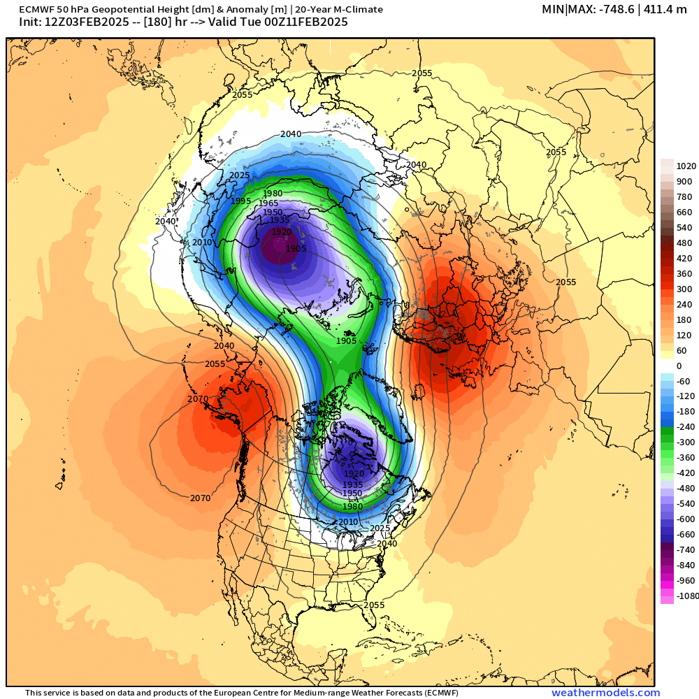
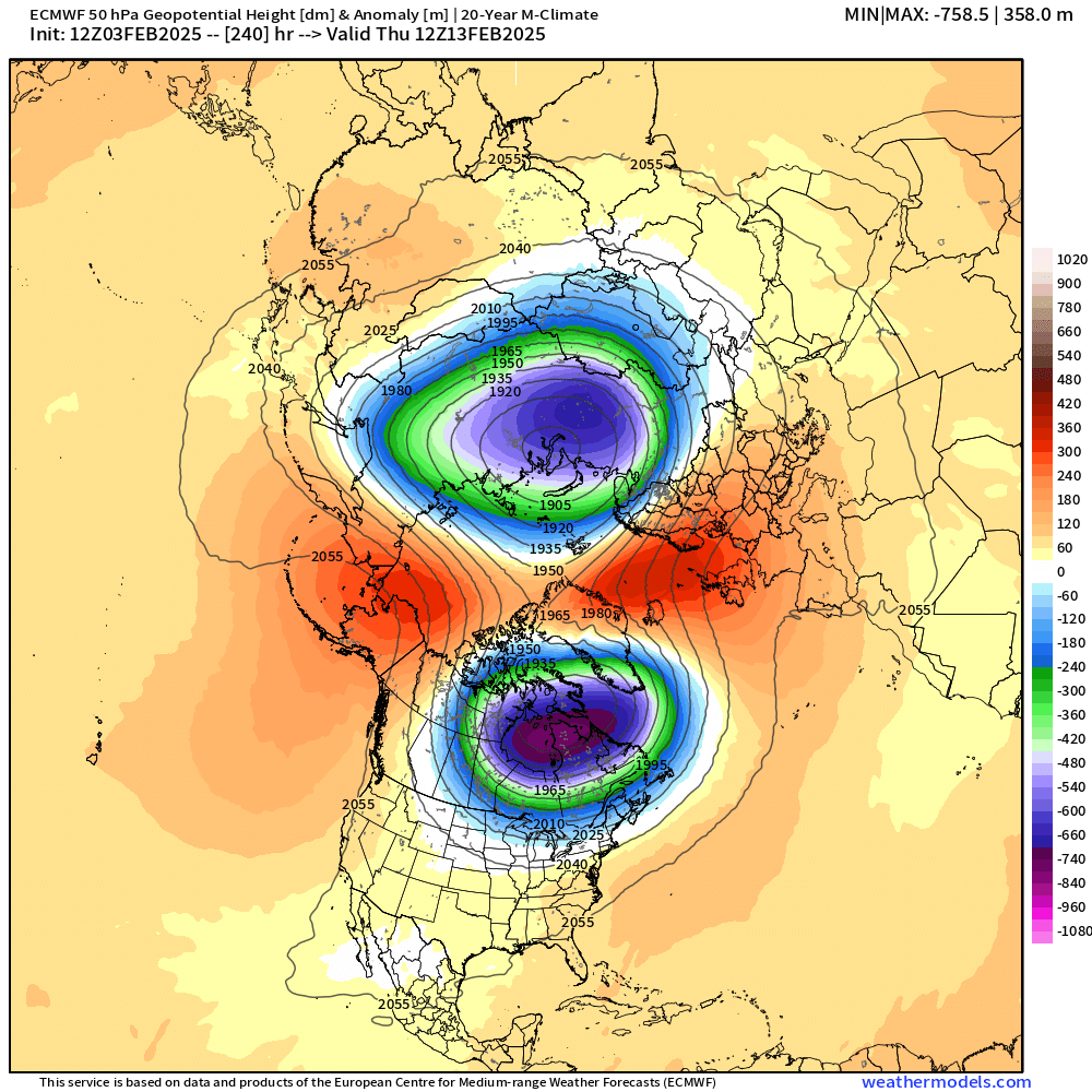
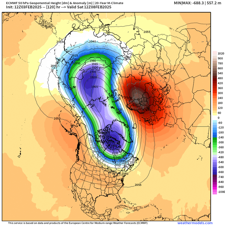
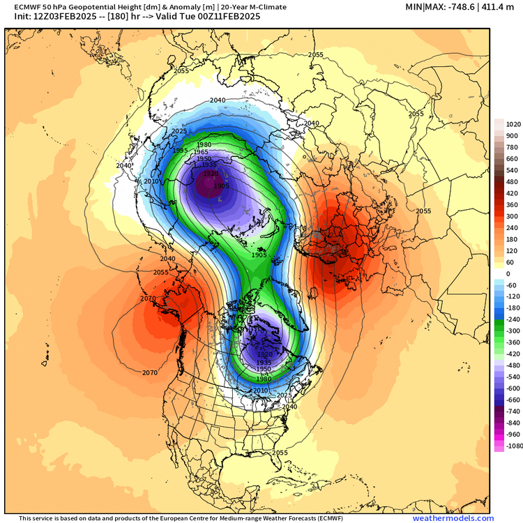
Yes. Stratospheric vortex basically elongated by 120h and fully split by D7…then I posted D10 at the bottom. This might have ramifications for prolonging the blocking into late February and March if we get a full SSW with a clean split

-
Those were weeklies I posted in January and I’d say they’ve done pretty well. They never fully bought a February torch unless we were talking about some of the progs from maybe prior to January 15th which is getting way out into clown range even for weeklies. Weeklies were def hinting at a coldish gradient pattern which is why I was somewhat optimistic despite February often sucking in La Ninas. Especially once the ensembles were showing the same thing as we got closer. This one looked like it could stay cold enough for a lot of chances. I don’t think the weeklies completely foresaw the huge PV displacement that looks like will occur but they were keeping that PV lurking just N of Hudson Bay
-
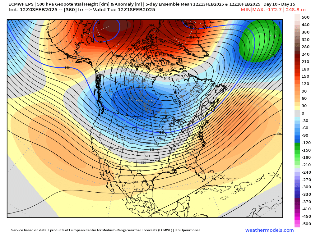
What a crazy arctic configuration by mid month
-
Euro has been waffling back and forth a bit on this threat. 12z run made the primary more zonked again so not much snow at all for CT/RI…and maybe only a couple of inches this solution for the pike region. But if you back off just slightly on that primary intrusion, then you could easily go 4-8” too. Details to be ironed out.
-
Tracking February 6. Light to moderate event potential
ORH_wxman replied to Typhoon Tip's topic in New England
Classic SWFE baking powder ratios. At least lower levels are nice and cold. -
Tracking February 6. Light to moderate event potential
ORH_wxman replied to Typhoon Tip's topic in New England
Def a period of IP/ZR but QPF won’t be prolific in this system so we prob don’t need to be worried about power issues, etc. But it will make driving and walking terrible. -
There’s like 3 events that are total rip offs from Jan/Feb ‘94. Hopefully we can cash in.