

ORH_wxman
-
Posts
93,099 -
Joined
-
Last visited
Content Type
Profiles
Blogs
Forums
American Weather
Media Demo
Store
Gallery
Everything posted by ORH_wxman
-
Sunday Evening/Night Light snow event Disco/Obs
ORH_wxman replied to Sey-Mour Snow's topic in New England
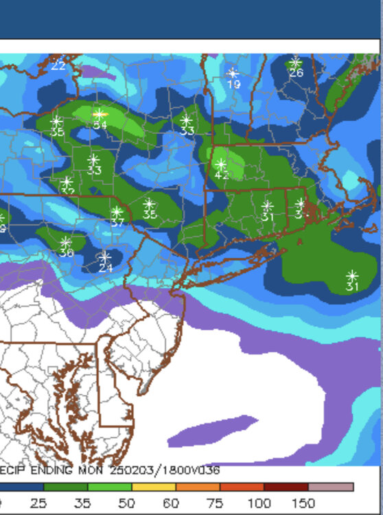
That’s a pretty nice swath of 0.25”+ on the 06z Euro and GFS is pretty similar…even more robust. So if you’re grabbing 15 to 1 on that it’s gonna produce a lot of 3-4” amounts…and maybe even a 5 spot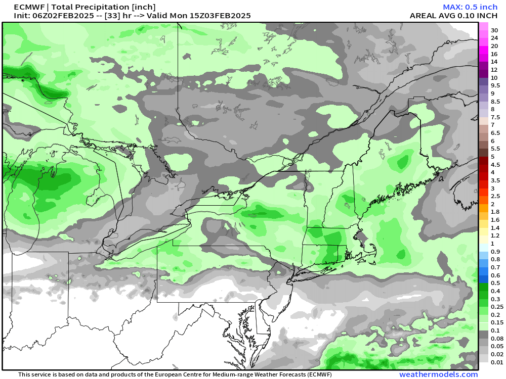
-
Sunday Evening/Night Light snow event Disco/Obs
ORH_wxman replied to Sey-Mour Snow's topic in New England
I could see some 3-4” lollis easily if the snow growth is there. Good airmass for this one. -
Tracking February 6. Light to moderate event potential
ORH_wxman replied to Typhoon Tip's topic in New England
Euro still the warmest on this threat but it looks like it ticked colder at 06z with a little more snow/ice on front end and better CAD reflection at sfc. Still think the threats after this one are more favorable for winter precip but this one could easily continue to tick colder. -
18z euro did cool a bit for midweek…still warmer than GFS but more sleet and ice on the front end (after pretty brief snow in SNE)…18z EPS does have some snowier members in there too so while my bet is GFS is too cold, we may see the OP euro cool at least a bit in the future.
-
Little mini-Montreal Express this afternoon and tonight. Despite the colder airmasses at times this winter, we haven’t had many on this type of delivery. These are the ones that bite a bit. We were falling even with the sun trying to poke out midday.
-
I mean, it doesn’t take too much imagination to see how the next 15 days leaves us with 4” of snow total that was all subsequently washed away in multiple amped systems where the primary is tracking through Ottawa. My gut though (and it’s not purely gut since it’s sort of supported by guidance) is that we cash in on a couple of these…they seem to get progressively more favorable the further out in time we go too…probably because the PV is slowly being pushed southward making it harder and harder to sustain warmer solutions the deeper in time we go.
-
Lol…the reason it’s funny is because zooming in on an EPS 15-day mean is completely worthless in value. It’s already pretty smoothed out too due to having 51 members so it’s not like the zoomed-out version is hiding intricate details.
-
Sunday Evening/Night Light snow event Disco/Obs
ORH_wxman replied to Sey-Mour Snow's topic in New England
You are plenty far north enough in this one for 1-3/2-4 depending on ratios. -
Sunday Evening/Night Light snow event Disco/Obs
ORH_wxman replied to Sey-Mour Snow's topic in New England
Really good antecedent airmass for this one so should be able to stack some decent ratios if we get the snow growth. GFS actually has a really good crosshair sig over CT and up near pike for a time. So if that can occur, might grab some fluff-lollis to 4 in spots. -
Pretty robust EPS run. They’ve gotten progressively better, but even several days ago it was hinting at some legit potential…which is why I was posting it amidst all the bridge-jumping
-
That was Zonties…that one was way back in the day. I think it was from Feb ‘06.
-
-
Yep. Midweek might be a struggle. Esp down here but the weekend looks pretty good on the eps mean. I don’t expect pristine systems but I’d love to get several big front enders that maybe change to sleet/ZR over interior before dryslotting. Get some meat in the pack if we’re gonna be dealing with a prolonged winter pattern into February.
-
I wouldn’t put too much credence in anything beyond D5 in this pattern in terms of specifics but this type of pattern is definitely ripe for lots of rapid fire chances. So I think it makes sense to see so many systems.
-
The snow and ice threats just kept going in clown range that run. It was like 6 events total over the 15 days. Crazy active.
-
Also pretty warm for next weekend too. But these are gonna move around a bit. I’d expect mid week to be kind of tough south of CNE but next weekend has better look.
-
This might be a chance for Ray’s area into SE NH to eat into those big negative snow anomalies the last few winters. These are the types of patterns that do well there. They need a few of these patterns to catch up, but can’t start without the first one happening.
-
GGEM is a bit more amped than GFS on both threats but still decent front enders with some sleet/ice in there too. Lot of chances in this pattern at least. Reminds me of some of those La Niña patterns in ‘07-08 and ‘08-09.
-
A half inch of QPF icing will produce around 2 tenths of radial ice assuming that all half inch accretes at perfect efficiency which won’t be the case. So you can probably lower it to 1-2 tenths of radial ice.
-
If by “moderate ice storm”, you mean a tenth or two of radial in-situ icing, then yeah, maybe.
-
Opera Man ending?
-
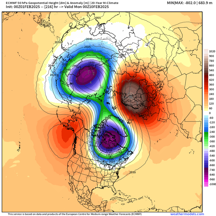
Correct there is no guarantee. But typically if you get a 50mb clean split, the chances are very good for enhanced blocking.
-
Yep, that’s why when I posted that 50mb strat look, i mentioned f things line up well, we can parlay the organic mid-February look into a stratospheric-induced favorable look into early March…kind of like double-dipping. We can use the stratosphere to prolong the fun (hopefully)…or prolong the torturous teasing, lol.
-
We might get lucky and parlay that into a nice late Feb/March pattern too. @CoastalWx, we’re moving it up to D9 now…hopefully we can get this inside of D7
-
PV gets pushed further south by the situation in the arctic. Seems like AO tries to go more negative. Almost north pole ridging poking up from the EPO and some retrograding Scandi-ridging.


