

ORH_wxman
-
Posts
93,099 -
Joined
-
Last visited
Content Type
Profiles
Blogs
Forums
American Weather
Media Demo
Store
Gallery
Everything posted by ORH_wxman
-
Those types of systems typically only have a narrow area of ice and usually it’s not stationary enough to give big amounts. Once in a while you might get a narrow band of warning ice but it’s pretty rare. My guess is the frozen precip will be dominated by snow and sleet.
-
GGEM has gone colder on the 2/1 threat too. Shows a big front ender with the classic looking bent back ML warm front that we often see on SWFEs.
-
PDII the storm itself was kind of pedestrian in terms of rates. It was basically like 1” per hour for 15 hours and then another couple inches each side of it. As far as 20” storms are concerned, def somewhat “boring” But the modeling aspect of it was quite exciting. It just kept inching north every run from like 4-5 days out. It was a clean whiff on a lot of guidance at D4 and then just a slow creep north. GFS was last to the party as usual back then. Took until really close for it to hammer SNE.
-
Yeah had about an inch down to the pike. Slide that another 50-75 miles south and maybe it can infuse a little more moisture into it.
-
Euro tries for front end on that one.
-
First week of Feb looks tough for snow…although that could always change. Ensembles and weeklies both def look decently cold for second week of Feb. Maybe we can mimick Feb 1972 pattern…that was a La Niña with kind of a dud Dec/Jan for snow and then Feb start off as the typical SE ridge torchy pattern but then it flipped middle of the month and several snow events including a major one occurred.
-
Holden was always a great weenie town for snow retention too. It’s elevated but largely sits in sort of a shallow valley between 1200+ foot Princeton to its north and 1200+ Paxton to its south so it holds cold air really well too.
-
I think that's when most of the difference happened....it stayed snow on winter hill that night but it was like pure slush falling from the sky....had about 4-5" the next morning on prob like 5 to ratios, lol. I remember Holden/Princeton already having a foot-plus the next morning. Winter hill then went roughly neck and neck with them the rest of the day as the column cooled a little bit....so we ended up near 15" while they got another 10-12 as well and finished over 25". I'm not even sure why Holden at similar (or even slightly lower elevation) was able to stay colder....maybe being just a smidge further west in longitude gave them a few tenths of upslope cooling in the column. Really crazy storm though to see that gradient where it was.
-
About 15" of mashed potatoes on Winter Hill.....26" in Holden 5 miles away and not even higher elevation.
-
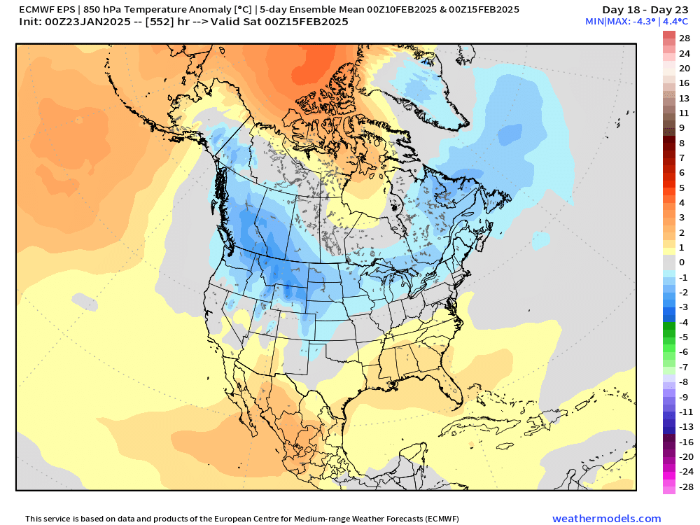
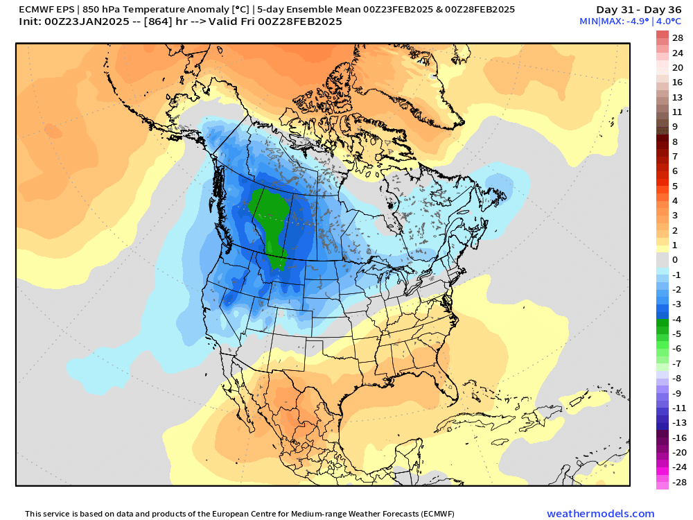
EPS trying to send most of the CONUS back into the deep freeze int he 2nd week of February. We'll see. Hopefully we can score something if there's going to be cold around.
-
CNE too....gets a ocuple inches down to N MA in the Rt 2 zone
-
LEts dig that clipper a bit more and have it look more like the 00z GFS.
-
It's funny that Pinkham Notch actually has one on record....lol. (Feb '69 storm)
-
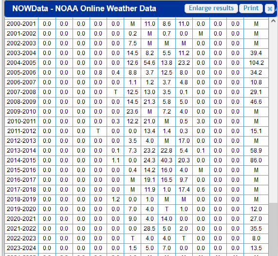
What's weird is once you mentioned the 113", I remember it too now. I wonder if something was revised. Did you get anything in November 2004? I noticed it's 0.0" but there was a decent event for SE MA I think on 11/13/04 but E Wareham may have been too far south.
-
NAM got a little too juicy inside of 36 hours on a few runs, but it was surprisingly tame before that which was kind of a red flag on those huge zonked solutions.
-
This is just a wild guess....but probably because he has like 8" of snow on the season and nothing interesting to track in the pipeline....
-
EPS has a decent number of SWFE members for that early Feb threat....could be a cutter, but could also end up colder. That's what you get in a gradient pattern.
-
Euro vastly outperformed the RGEM inside of 72 hours. The RGEMs cousin, the GGEM, performed better than the Euro in the medium range...Like D5-6. But the RGEM only goes out to 84 hours....but by that time, the Euro already had an event and it was mostly advisory snows (which is what verified for the most part) while the RGEM was showing these crazy zonked solutions giving western MA/E NY State and VT/NH a foot of snow or more while everyone east of ORH was mostly rain....it was a really bad performance by that model.
-
No i still see it on the BOX site. But the 2010s decade for E Wareham is pretty bad on data....a lot of missing data, but it appears to have gotten better again more recently in the 2020s.
-
RGEM performed poorly IMHO....way too amped and much higher impact than the storm actually was.
-
Also, back where he is, the return rate on those big dogs is a bit lower than a place like E MA. It’s a little harder further away from the moisture source…they’ll get more nickel and dime events there to make up for it….the seasonal average might be similar to a place like interior SE MA but the distribution of snowfalls is a little different.
-
2/28-3/1 I think you mean? That was the “convective blob” storm. We were supposed to get like 8-12” over the interior but we busted a bit low (maybe had about 6” like you) because of that massive blob. It looked like an MCS. We were tracking it on WWBB at the time and messenger in PYM started reporting freaking silver dollars falling from the sky…they were getting 5” per hour. We weren’t sure if it would be all snow down there because the column was marginal…but it went isothermal. I think he got a total of 16” in about 5 hours. It was crazy…I remember him posting a pic in the middle of it and seeing nothing but silver dollars and the street light about 100 yards away was like a dim light in fog.
-
‘88-89 was fairly cold and one of my worst winters. Just bone dry. We did mix a couple cutters in for fun. But just horrific. This winter is kind of reminding me of that…not quite as cold but similar lack of snow. December was much wetter this winter but since Xmas it’s been fairly similar. At least I have a warning event this winter. We couldn’t even get one that year.
-
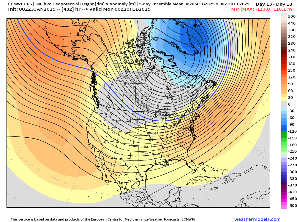
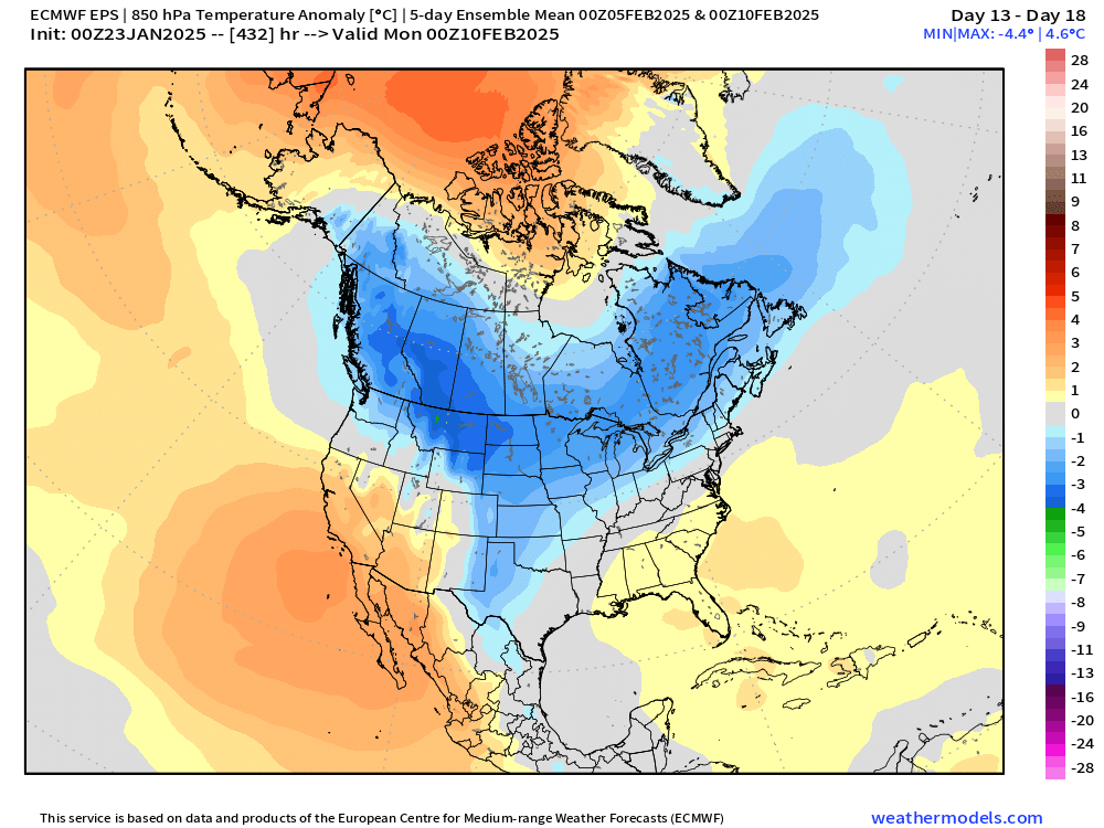
Here’s a sample…H5 first set and H85 temp second set


-
Basically the first week of February and goes all month according to weeklies. Take with a grain of salt obviously the further out you go…but I’ll say the weeklies have actually performed pretty well this winter so far.


